Wray Castle

Wray Castle: Victorian neo-gothic mansion in the Lake District
Modern (19th–20th c.)
Well Preserved

Wray Castle is a striking example of a Victorian neo-gothic mansion located in the picturesque Lake District, within the parish of Claife, England. Built in the 19th century, it stands as a testament to the architectural tastes and social aspirations of the Victorian era, embracing the romantic revival of Gothic design elements. The castle's style is characterized by its pointed arches, decorative tracery, and steeply pitched roofs, all hallmarks of the neo-gothic architectural movement that flourished during this period.

The castle was constructed as a country house rather than a military fortress, reflecting the shift in castle-building purpose during the Modern period. Its design prioritizes aesthetic appeal and comfort, incorporating large windows and ornate interiors suited for leisure and social gatherings. The structure is set within extensive grounds that include part of the shoreline of Windermere, England's largest natural lake, enhancing the estate's scenic and recreational value.

Architectural features and design

Wray Castle's architecture showcases the typical neo-gothic elements popular in the Victorian era, including turrets, battlements, and decorative stonework. The building's layout centers around a grand hall, with multiple chambers and reception rooms arranged for both private living and entertaining guests. The use of pointed arches in windows and doorways, along with the intricate woodwork and stone carvings, reflects the revivalist enthusiasm for medieval Gothic motifs.

The castle's exterior is constructed from local stone, lending it a robust yet picturesque appearance. The steeply pitched roofs and tall chimneys add to the vertical emphasis typical of neo-gothic design. Inside, the interiors blend Victorian craftsmanship with Gothic revival aesthetics, featuring ornate fireplaces, stained glass windows, and detailed plasterwork ceilings.

Grounds and natural surroundings

The estate surrounding Wray Castle is notable for its extensive and carefully curated gardens and parkland. Since coming under the care of the National Trust in 1929, the grounds have been maintained to preserve their natural beauty and historical planting schemes. Visitors can explore a variety of specimen trees, including Wellingtonia (giant sequoia), redwood, Ginkgo biloba, weeping lime, and various beech varieties, which contribute to the diversity and visual interest of the landscape.

The grounds also include access to the shoreline of Windermere, offering scenic walking paths and opportunities for lakeside recreation. The parkland's mixture of mature trees and open spaces creates a tranquil environment that complements the castle's romantic architectural style.

Historical context and ownership

Wray Castle was originally built as a private residence during the Victorian era, reflecting the period's fascination with medieval revival styles and the growing trend of country houses as symbols of wealth and status. Its location in the Lake District connects it to the broader cultural history of the region, known for inspiring Romantic poets and artists.

The property was acquired by the National Trust in 1929, marking its transition from private home to public heritage site. Although the house itself was not regularly open to the public for many years, recent efforts have made it accessible for visitors interested in Victorian architecture and the natural beauty of the Lake District.

Visitor experience and amenities

Today, Wray Castle offers a unique visitor experience combining architectural appreciation with outdoor activities. The castle's interiors provide insight into Victorian neo-gothic design, while the grounds invite exploration and relaxation. The site is open year-round, with the gardens and parkland freely accessible, making it a popular destination for families, walkers, and history enthusiasts.

Educational programs and guided tours are occasionally available, focusing on the castle's architectural significance and its role within the Lake District's cultural landscape. The National Trust manages the site with an emphasis on conservation and public engagement, ensuring that Wray Castle remains a cherished heritage asset.

Frequently asked questions (FAQ)

How do I get to Wray Castle?
Wray Castle is located near Windermere in the Lake District, accessible by car and local bus services. There is parking available on site for visitors.
What are the opening hours of Wray Castle?
The grounds of Wray Castle are open all year round. The house itself has recently opened to the public on a regular basis; it is best to check the National Trust website for current visiting hours.
Is Wray Castle suitable for family visits?
Yes, Wray Castle and its grounds offer a family-friendly environment with plenty of space for children to explore. The gardens and lakeside paths are ideal for outdoor activities.
What architectural style is Wray Castle built in?
Wray Castle is built in the Victorian neo-gothic style, featuring turrets, battlements, pointed arches, and decorative stonework typical of the Gothic revival.
Can I visit the shoreline of Windermere from Wray Castle?
Yes, the estate includes part of the shoreline of Windermere, allowing visitors to enjoy scenic lakeside walks and views.

Information

Palace Castle

Current owner

National Trust

Sources & official resources

Verify the information above using these authoritative references.

Loading map...

Visitor reviews

No reviews yet. Been here? Write the first review and help other travelers!

Write the first review

Visited this castle? Share your experience

Your review helps other travelers and adds first-hand knowledge to our encyclopedia.
Write a review

(5/5)

0/2000 characters

Your review will be visible after admin approval

Nearby castles

14.3 km

Sizergh Castle

Helsington, United Kingdom

Sizergh Castle is a remarkable example of a late medieval hill castle situated near Kendal in Cumbria, England. This historic estate has been under the stewardship of the Strickland family for over seven centuries, making it one of the longest continuously held family seats in England. The castle and its gardens, now cared for by the National Trust, offer a rich architectural and historical narrative spanning from the 14th century through the Georgian period. The origins of Sizergh Castle trace back to the early 14th century, with initial construction beginning around 1310. The oldest surviving part is a distinctive four-story tower built circa 1343, notable for its trefoil-shaped windows that exemplify medieval decorative motifs. Over the centuries, the castle evolved architecturally, reflecting the tastes and necessities of its owners through the Tudor, Elizabethan, and Georgian periods. This blend of styles creates a layered visual history that is both unique and evocative of England’s aristocratic heritage. Historical background and family legacy The estate originally belonged to the Deincourt family from the late 12th century. The transition to the Strickland family occurred in 1239 when Elizabeth Deincourt married Sir William de Strickland. This union marked the beginning of an unbroken family tenure that has lasted for over 700 years. Throughout this time, the family has played a significant role in regional and national history, including their allegiance to the Royalist cause during the English Civil War. During the 16th century, Sizergh Castle gained royal connections, notably with Catherine Parr, the sixth wife of King Henry VIII, who is believed to have resided here after 1533. The castle also reflects the family's Jacobite sympathies, evident in their collection of portraits of the Catholic Royal Stuart family, including works by the court painter Alexis Simon Belle. Architectural evolution and notable features Medieval tower and defensive elements The four-story tower built around 1343 is the castle's oldest standing structure. Its trefoil-shaped windows are a distinctive feature from the medieval period, combining both aesthetic and defensive functions. The tower's robust stone construction exemplifies the architectural priorities of the time, focusing on fortification and status. Tudor and elizabethan expansions Significant alterations in the late 15th century by Sir Thomas Strickland introduced Tudor elements that expanded the castle’s residential and functional spaces. The castle’s layout was adapted to reflect the changing needs of comfort and style during the Tudor and Elizabethan eras, incorporating larger windows and more elaborate interiors. Georgian modifications In the 18th century, the castle underwent Georgian-style renovations, particularly in the great hall and entrance areas. These modifications introduced classical architectural elements and refined the castle’s aesthetic, blending the medieval fortress with more modern tastes. Interior highlights and collections The castle’s interiors are renowned for their fine oak wood paneling, especially in the Inlaid Chamber. This room features intricately decorated panels with floral and geometric patterns created by inlaying pale poplar and dark bog-oak, producing a striking three-dimensional effect. Early furnishings dating from the 16th century, including oak armchairs and chests, survive and are documented in historic inventories. Portraits of the Strickland family and the Catholic Royal Stuart family adorn the walls, including works by notable artists such as Alexis Simon Belle, George Romney, and Harriet Strickland. These collections reflect the family’s cultural interests and political affiliations over several centuries. Gardens and estate landscape Surrounding the castle is an extensive estate covering approximately 647 hectares, featuring a Grade II listed garden with a lake, kitchen garden, and the largest limestone rock garden owned by the National Trust. This rock garden, created in the 1920s, is home to part of the National Collection of Ferns, which thrives in the rock garden, orchard, and stump garden areas. The estate's landscape is historically significant, with a royal grant from Edward III in 1336 allowing Sir Walter Strickland to enclose the grounds as a private park. This early example of landscape management highlights the estate’s longstanding importance and the family’s status. Preservation and public access In 1950, Thomas Hornyold-Strickland, 7th Count della Catena, a descendant of the first Baron Strickland, gifted Sizergh Castle and its gardens to the National Trust. This act ensured the preservation of the castle and its estate for future generations. The castle remains well preserved, with many original features intact, offering visitors a comprehensive glimpse into England’s aristocratic past. The castle and gardens are open to the public, providing educational and cultural experiences that showcase its architectural splendor and historical significance. In 2016, the estate was incorporated into the extended Lake District National Park, further protecting its natural and historic environment within one of England's most treasured landscapes.

Late Medieval (14th–15th c.)
Details
14.8 km

Castle Howe

Kendal, United Kingdom

Castle Howe stands as a significant Norman motte-and-bailey fortress overlooking the historic town of Kendal in Westmorland, England. Constructed in 1092, it represents the earliest castle in Kendal and a pivotal element in the Norman efforts to consolidate control over the region during the late 11th century. This castle embodies the strategic military architecture typical of the Norman conquest period, designed to assert dominance and provide defense in newly acquired territories. The strategic importance of Castle Howe The castle was built during a period when the Normans were extending their influence northwards, aiming to subjugate the lands of Westmorland. The establishment of Castle Howe was part of this broader military campaign. The site was chosen for its commanding views over Kendal and the surrounding landscape, allowing for effective surveillance and control. The castle's location on a natural rise made it an imposing feature and a deterrent to potential rebellions. Architectural features and layout The motte The centerpiece of Castle Howe is its well-preserved motte, an artificial earth mound typical of Norman military design. The motte rises approximately 33 feet (10 meters) above the surrounding terrain and measures around 59 feet (18 meters) in diameter at the summit. At its base, the motte spans approximately 150 feet (46 meters) in diameter, demonstrating the substantial scale of the earthworks involved in its construction. The motte would originally have supported a wooden or possibly stone keep, serving as the last line of defense and the residence of the lord or garrison commander. Although no standing keep remains today, the earthworks clearly define the original structure's footprint. The bailey and defensive works To the east of the motte lies the bailey, an enclosed courtyard typical of motte-and-bailey castles. The bailey at Castle Howe is roughly triangular in shape and was originally surrounded by a defensive palisade and ditch, which would have provided additional protection for the castle’s inhabitants and their livestock. Today, the bailey area has been transformed into a public park and bowling green, but the earthworks still mark the perimeter of the original fortifications. The surrounding ditches and embankments remain visible, offering insight into the castle’s defensive layout. Historical context and ownership The castle’s construction is closely linked to Ivo de Taillebois, a Norman nobleman who was granted the Barony of Kendal around 1092. Ivo was rewarded for his military support to the Norman cause with extensive lands that included parts of present-day Yorkshire, Lancashire, and Cumbria. Castle Howe served as a symbol of his authority and a military stronghold to secure his holdings. Although the castle itself was primarily a military installation, it played a role in the administration and control of the Barony of Kendal during the turbulent years following the Norman conquest of England. Preservation and current status Today, Castle Howe is classified as a partially preserved motte-and-bailey castle. While no significant masonry structures survive, the earthworks remain remarkably intact. The motte and bailey provide a clear example of Norman defensive architecture and are an important heritage site in Kendal. The site is accessible to the public as a park, offering visitors the opportunity to explore the impressive earthworks and appreciate the castle’s historical significance within the landscape of northern England. Castle Howe’s legacy in Norman military architecture Castle Howe exemplifies the typical Norman strategy of rapid castle construction using earth and timber to establish control over newly conquered areas. Its motte-and-bailey design was a common feature of early Norman castles, combining a raised defensive mound with an enclosed courtyard to provide both protection and functional space. The castle’s enduring earthworks offer valuable insight into medieval military engineering and the Norman approach to territorial governance. As Kendal’s first castle, Castle Howe laid the foundation for the town’s development and remains a key historical landmark in the region.

High Medieval (11th–13th c.)
Details
15.7 km
Hardknott Roman Fort — United Kingdom castle

Hardknott Roman Fort

Eskdale, United Kingdom

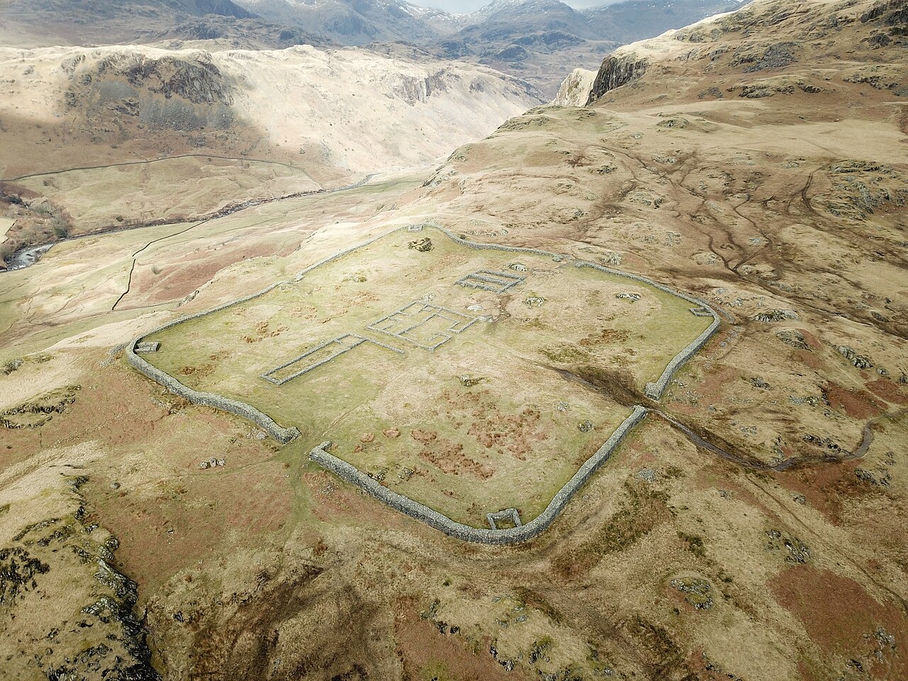
Hardknott Roman Fort, known in antiquity as Mediobogdum, is a significant archaeological site located in the English Lake District, within the modern ceremonial county of Cumbria. This fortification stands on a rocky spur on the western side of the steep and challenging Hardknott Pass, a strategic mountain route connecting the coastal region with the interior valleys. The fort's position reflects Roman military strategy to control key transportation routes and to secure the frontier of the Roman province of Britannia. Historical background and construction The construction of Mediobogdum dates back to the early 2nd century AD, specifically between 120 and 138 AD, during the reign of Emperor Hadrian. This period saw significant Roman military activity aimed at consolidating control over northern Britain, including the building of Hadrian's Wall. The fort was built as part of a network of fortifications designed to monitor and control movement through the region. The fort was originally garrisoned by the Cohors IV Delmatarum, an auxiliary infantry unit recruited from the Dalmatian coast (modern-day Croatia). This unit's presence illustrates the Roman practice of stationing troops far from their homelands to reduce local sympathies and increase loyalty to Rome. Hardknott Roman Fort was constructed on a naturally defensible rocky spur, which was enhanced by Roman engineering techniques. The fort's layout was roughly rectangular, enclosed by strong defensive walls and towers. Its design included typical Roman military architectural features such as gates, barracks, granaries, and a principia (headquarters building). Military use and occupation phases The fort's initial occupation lasted about a decade before it was abandoned, likely due to shifts in military priorities or local conditions. Around 200 AD, the site was reoccupied and remained in use for much of the next two centuries, reflecting its ongoing strategic importance. This second phase of occupation coincided with renewed Roman efforts to maintain frontier defenses and control over northern Britain. Throughout its use, the fort served as a base for controlling the surrounding territory, overseeing local populations, and securing the vital pass. Its location allowed Roman forces to monitor movements and respond quickly to any threats or incursions. Architectural features and layout Although now in ruins, the remains of Hardknott Roman Fort reveal the typical characteristics of a Roman auxiliary fort. The fort was enclosed by a stone wall with bastions at intervals, providing defensive strength against attacks. The bastions allowed defenders to cover the walls with crossfire, enhancing the fort's security. Inside the walls, the layout followed a standard Roman military plan. The central principia housed administrative offices and a shrine, while barracks accommodated the soldiers. Granaries ensured a stable food supply, and workshops supported maintenance and repairs. Roads within the fort connected the main gates and buildings, facilitating efficient movement. The fort's elevated position on a rocky spur not only provided natural defense but also commanding views of the surrounding landscape, including the valleys below and the mountain passes. This vantage point was crucial for surveillance and early warning. Later history and preservation After the Roman withdrawal from Britain in the early 5th century, Hardknott Roman Fort fell into disuse and gradually became a ruin. Over the centuries, the site was subject to natural decay and occasional stone robbing for local building projects. Despite this, substantial remains of the fort's walls and structures have survived, offering valuable insights into Roman military architecture and presence in northern England. Today, the fort is located on land owned by the National Trust, within the Trust's Wasdale, Eskdale, and Duddon property holdings. It is maintained and managed by English Heritage, ensuring its protection and accessibility to the public. The site lies within the civil parish of Eskdale in the unitary authority area of Cumberland. Visitors to Hardknott Roman Fort can explore the ruins and appreciate the challenging terrain that Roman soldiers once guarded. Interpretive signage and pathways help to explain the fort's historical context and architectural features, making it a valuable educational resource. Significance in Roman Britain Hardknott Roman Fort represents an important example of Roman military engineering and frontier strategy in northern Britain. Its location on a difficult mountain pass illustrates the Roman emphasis on controlling key routes and maintaining communication lines. The fort's occupation by an auxiliary cohort from Dalmatia highlights the diversity of the Roman army and its deployment across the empire. As one of the highest Roman forts in Britain, Hardknott offers unique insights into the challenges faced by Roman forces operating in rugged and remote environments. The site's archaeological remains contribute to understanding the broader network of Roman fortifications that supported the empire's northern frontier.

High Medieval (11th–13th c.)
Details