The Rock of Dunamase
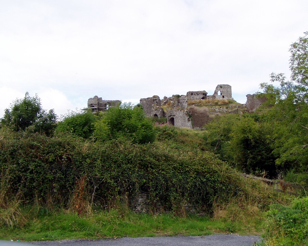
The Rock of Dunamase is a prominent hill castle ruin located in County Laois, Ireland, perched atop a commanding rocky outcrop that rises approximately 46 metres above the surrounding flat agricultural landscape. This historic site is notable for its long and layered history, spanning from its origins as an early medieval hill fort in the 9th century to a significant Norman castle built in the 12th century, and its eventual decline into ruin by the 14th century. The site today offers a compelling glimpse into Ireland's turbulent past, reflecting the successive waves of conquest, settlement, and resistance that shaped the region.
The rocky prominence known as Dunamase was initially fortified during the early medieval period with an Iron Age hill fort or dún, a term meaning fort in Irish, constructed to oversee and control the surrounding plains. This strategic location was first recorded in historical annals during the mid-9th century when it suffered attacks by Viking raiders in 842 and again in 845. These raids were significant enough to cause disruption not only militarily but also to nearby monastic communities, including the death of the abbot Aed son of Dub dá Chrích from the Terryglass monastery. Despite these early conflicts, continuous occupation during the 10th and 11th centuries remains uncertain.
Norman conquest and castle construction
Following the arrival of the Normans in Ireland in the late 12th century, the Rock of Dunamase became a key site for establishing Norman authority in the region. Around the latter half of the 12th century, a stone castle was constructed on the rocky hill, embodying typical early Norman military architecture designed for both defense and residence. This castle was part of a broader network of fortifications built to secure Norman control over Leinster and surrounding territories.
The castle gained prominence as a strategic stronghold during the reign of Dermot Mac Morrough, the King of Leinster, who used it in his military campaigns. Importantly, the castle was included in the marriage settlement when Dermot gave it to Richard de Clare, known as Strongbow, in 1170, marking a pivotal moment in the Norman consolidation of power in Ireland. Ownership subsequently passed through several influential Anglo-Norman families, including the Marshals and the Mortimers, who maintained the castle until the early 14th century.
Decline and Gaelic resurgence
By the mid-14th century, the castle had fallen into disrepair, reflecting the waning Norman influence in the area. Around this time, the local Gaelic clan, the O’More (Ó Mórdha), rose to prominence and took control of the site. The castle became a Gaelic lordship seat throughout the 15th and 16th centuries, symbolizing the resurgence of native Irish power in the region.
One of the notable figures associated with the castle during this period was Rory O’More, a chieftain who played a significant role in local resistance against English encroachment. The O’More family retained possession of the castle until 1574, when they relocated to Kildare following land grants from Queen Elizabeth I. This marked the end of the castle’s role as a Gaelic stronghold.
Destruction and later history
In 1650, during the Cromwellian conquest of Ireland, the castle was deliberately damaged by military forces to prevent its use as a defensive position. This slighting effectively ended its military significance, and the castle remained a ruin thereafter. Unlike many other Irish castles, it did not play a direct role in the many rebellions or wars that preceded this event.
In the late 18th century, efforts to repurpose the ruins were undertaken by Sir John Parnell, who began constructing a banqueting hall within the castle walls. This project incorporated medieval architectural fragments salvaged from other nearby sites, blending new construction with the historic fabric of the castle. However, the restoration was never completed, and the site remains a ruinous archaeological complex.
Architectural features and layout
The remains of the Rock of Dunamase include the ruins of the Norman castle and the earthworks of the earlier ring-fort. The castle’s layout reflects the defensive priorities of its builders, featuring a central great hall surrounded by a curtain wall or imbhalla in Irish. This wall enclosed the inner courtyard and provided protection against attackers.
Key defensive elements include a gatehouse on the southeastern side, which served as the main fortified entrance, and an adjoining barbican, an outer courtyard designed to slow and expose attackers before they reached the gate. Additionally, a postern gate on the southern side allowed for discreet exit or entry during sieges.
The castle’s elevated position afforded commanding views over the surrounding plains and toward the Slieve Bloom Mountains, enhancing its strategic value. The rugged rocky outcrop itself posed natural defensive advantages, though the site’s geology may have contributed to difficulties in sustaining permanent structures over the centuries.
Present condition and cultural significance
Today, the Rock of Dunamase stands as a partially preserved ruin and an important archaeological site. It offers visitors a tangible connection to Ireland’s layered history of early medieval fortifications, Norman military architecture, and Gaelic lordship. The ruins, including the earthworks and castle remains, are a testament to the site’s strategic importance and the complex history of conquest and resistance in the region.
As a cultural landmark, the Rock of Dunamase is valued for its historical associations with significant figures such as Strongbow, Dermot Mac Morrough, and the O’More clan. It also illustrates the evolution of castle architecture in Ireland from early medieval ring-forts to Norman stone castles and later adaptations.
Visitors to the site can explore the ruins and appreciate the commanding views that once made the Rock of Dunamase a coveted defensive position. The site remains a poignant reminder of Ireland’s turbulent history and the enduring legacy of its medieval fortifications.
Frequently asked questions (FAQ)
- How do I get to the Rock of Dunamase?
- The Rock of Dunamase is located in County Laois, Ireland. It is accessible by road from nearby towns such as Portlaoise. Visitors should check local maps and travel guides for the best routes.
- What is the historical significance of the Rock of Dunamase?
- The Rock of Dunamase is significant for its origins as an early medieval hill fort and later as a Norman castle. It played a role in Viking raids, Norman conquest, and Gaelic lordship, reflecting Ireland's complex history.
- Can I explore the castle ruins at the Rock of Dunamase?
- Yes, visitors can explore the ruins of the Norman castle and the earlier ring-fort earthworks. The site offers scenic views and insights into medieval fortification architecture.
- When was the castle built and by whom?
- The stone castle on the Rock of Dunamase was built in the 12th century during the Norman period. It was constructed as part of the Norman expansion into Ireland following their arrival in the late 1100s.
- Is the Rock of Dunamase accessible year-round?
- The site is generally accessible year-round, but visitors should check local conditions and opening times if applicable, as it is an outdoor archaeological site.
Information
Website
Visit websiteSources & official resources
Verify the information above using these authoritative references.
Loading map...
Visitor reviews
No reviews yet. Been here? Write the first review and help other travelers!
Write the first reviewVisited this castle? Share your experience
Your review helps other travelers and adds first-hand knowledge to our encyclopedia.