Rogóźno-Zamek — Poland castle

Rogóźno-Zamek

Rogóźno-Zamek castle: ruins of a late medieval Teutonic fortress in Poland
Rogóźno-Zamek, Poland
Late Medieval (14th–15th c.)
Ruins

Rogóźno-Zamek castle stands as a significant relic of the late medieval period in Poland, embodying the architectural and historical legacy of the Teutonic Order. Perched on a hill overlooking the confluence of the Gardęga and Osa rivers, the castle’s ruins mark one of the oldest fortifications in the Chełmno Land. Originally, the site hosted an early medieval stronghold before the Teutonic Knights seized it in the mid-13th century. Between 1250 and 1260, they erected a wooden and earthwork watchtower to guard the vital route from Grudziądz to Pomerania. By the late 13th century, this was replaced with a substantial brick castle, reflecting the strategic importance and permanence of the site.

Architectural layout and defensive features

The castle’s design follows the typical Teutonic conventual model, occupying two plateaus shaped by natural ravines carved by the Osa and Gardęga rivers. The complex consisted of three main parts: the upper castle (main castle), the middle bailey (inner outer bailey), and the outer bailey (external outer bailey). The upper castle, built on a rectangular plan, featured a four-winged irregular building surrounding a small inner courtyard with a well. The southern wing housed the chapel and infirmary, the western wing contained the refectory, and the northern wing included the kitchen facilities. The eastern wing incorporated the main gatehouse with a bridge over a moat connecting it to the middle bailey.

The middle bailey was fortified with double-layered walls on the southern side and reinforced with towers and a seven-story gate tower that guarded a partly drawbridge-supported entrance. This gate tower was equipped with a portcullis and a heavy wooden gate, designed to repel attackers. The outer bailey, occupying a larger plateau separated by a deep dry moat, was enclosed by defensive walls with numerous towers and open bastions facing inward. It contained residential and economic buildings for the castle’s garrison and servants.

The castle’s brick construction employed the Wendish bond pattern, alternating bricks laid lengthwise and widthwise for strength and aesthetic effect, with fieldstones reinforcing the plinth zone. This masonry technique was common in Teutonic fortifications and contributed to the castle’s durability.

Historical significance and ownership

Rogóźno-Zamek castle was initially the seat of a komtur from 1285 to 1333, overseeing the Teutonic Order’s military and administrative affairs in the region. Subsequently, it served as the residence of a vogt (civil administrator) until 1454. The castle played a role in key historical events, including hosting the Teutonic Order’s general chapter meeting between 1309 and 1312, attended by 51 commanders. Notable commanders such as Fryderyk von Wenden, who participated in the Battle of Grunwald in 1410, governed the castle.

Following the Teutonic defeat at Grunwald, Polish forces briefly occupied the castle in 1410 and again in 1414 during the Hunger War. During the Thirteen Years’ War (1454–1466), members of the Prussian Confederation seized the fortress. The Teutonic Knights set fire to the castle before abandoning it, causing limited damage. After the Second Peace of Thorn in 1466, the castle became part of the Kingdom of Poland, serving as the seat of a royal starost and later the management center of a royal economy from 1590.

The castle’s decline began in the 17th century due to the Polish-Swedish wars. In 1628, King Gustavus Adolphus of Sweden inflicted severe damage using experimental mining techniques. Further destruction occurred during the 1656 Swedish invasion, leaving the fortress in ruins by 1686. In the 18th century, King Frederick II of Prussia ordered its demolition, recycling the bricks for the construction of the Grudziądz citadel.

Preservation and current state

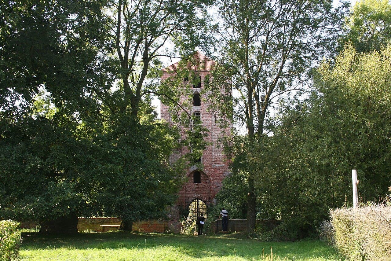
Despite centuries of destruction and dismantling, significant remnants of Rogóźno-Zamek castle survive. The best-preserved element is the seven-story gate tower of the middle bailey, along with large sections of the surrounding walls and a cylindrical corner turret. The bridge’s brick piers remain visible, illustrating the castle’s original access route. The outer bailey’s defensive walls and open bastions are partially integrated into existing farm buildings, providing a glimpse into the castle’s extensive fortifications.

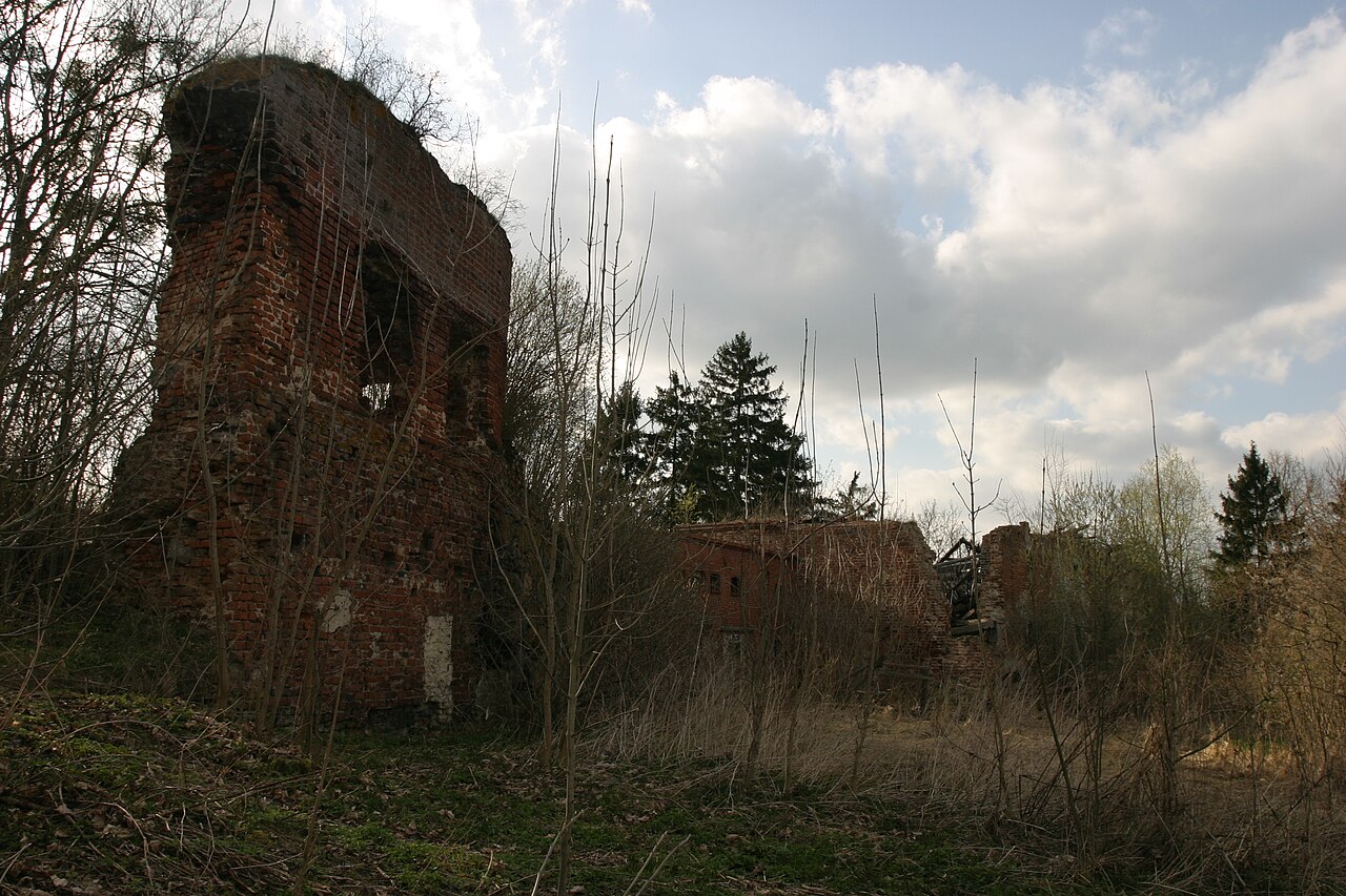
The upper castle site is now wooded, with only faint traces of the ground floor walls discernible. The castle’s chapel once housed a notable Madonna shrine from circa 1390, now preserved in the Germanisches Nationalmuseum in Nuremberg. A small museum inside the gate tower presents the castle’s history and artifacts.

The castle grounds include part of the Rogóźno-Zamek nature reserve on the slopes of the castle hill, while the outer bailey area is privately owned. Conservation efforts began in the early 20th century, with restoration work in 1911 and further repairs in 1952. Today, the ruins stand as a testament to the region’s medieval heritage and the architectural prowess of the Teutonic Order.

Architectural and military context

Rogóźno-Zamek was part of the Teutonic Order’s third defensive line, alongside castles such as Grudziądz, Engelsburg, Rehden, and Strasburg. It was linked historically with earlier fortifications like the Prussian stronghold Rogaw and Starkenberg Castle, dismantled around 1275. The castle’s design incorporated Gothic architectural features common to Teutonic fortresses, including brick walls, gatehouses with zwingers (enclosed killing grounds), and flanking towers to cover vulnerable approaches.

The castle’s strategic location utilized natural defenses provided by steep ravines and rivers, enhancing its military effectiveness. Its layout with multiple baileys and concentric fortifications reflected evolving medieval military architecture focused on layered defense and control of key routes.

Frequently asked questions (FAQ)

How do I get to Rogóźno-Zamek castle?
Rogóźno-Zamek castle is located in the village of Rogóźno-Zamek in the Kuyavian-Pomeranian Voivodeship of Poland. It is accessible by local roads from nearby towns such as Grudziądz. Visitors should check local maps and transportation options for the best route.
What are the opening hours of the castle?
As the castle is in ruins and partly on private land, there are no formal opening hours. Visitors are advised to respect private property and visit during daylight hours. Guided tours may be available by arrangement with the landowner.
What is the historical significance of Rogóźno-Zamek castle?
Rogóźno-Zamek castle was a key Teutonic fortress from the 13th to 15th centuries, serving as a military and administrative center. It played roles in the Battle of Grunwald, the Hunger War, and the Thirteen Years’ War, reflecting the turbulent history of the region.
Can I explore the ruins of the castle?
Yes, visitors can explore the ruins, including the well-preserved gate tower and sections of defensive walls. However, some areas are on private land, so access may be limited. It is recommended to obtain permission or join guided tours when available.
Is the castle wheelchair accessible?
Due to the castle’s ruined condition and uneven terrain, it is not wheelchair accessible. Visitors should be prepared for walking on rough ground and steep slopes.
When is the best time to visit Rogóźno-Zamek castle?
The best time to visit is during the warmer months from late spring to early autumn when weather conditions are favorable for outdoor exploration. This period also offers better visibility of the ruins and surrounding nature reserve.

Photo gallery

Rogóźno-Zamek
Click to view

Photo by Krzyo•CC BY-SA 3.0 pl

1 photo • Click any image to view in full screen

Information

Hill Castle

Current owner

Private owner

Sources & official resources

Verify the information above using these authoritative references.

Loading map...

Visitor reviews

No reviews yet. Been here? Write the first review and help other travelers!

Write the first review

Visited this castle? Share your experience

Your review helps other travelers and adds first-hand knowledge to our encyclopedia.
Write a review

(5/5)

0/2000 characters

Your review will be visible after admin approval

Nearby castles

11.5 km
Pokrzywno — Poland castle

Pokrzywno

Pokrzywno, Poland

Pokrzywno Castle stands as a remarkable example of a high medieval hill castle built by the Teutonic Order in the late 13th century in what is now Poland. Its ruins occupy a strategic location at the confluence of the Marusza River and a small stream, a site previously occupied by a Slavic stronghold. The original Slavic fortification was granted in 1222 by Prince Konrad of Mazovia to the missionary bishop Christian. In 1231, the bishop transferred ownership of the Pokrzywno lands to the Teutonic Knights, who initially constructed a wooden and earth fortification named Engelsburg, or "Castle of the Angel." By the mid-13th century, the Knights began erecting a stone castle on the site, adapting the design to the natural terrain rather than following the later typical four-winged convent castle layout. The castle was built on an irregular polygonal plan, making it one of the oldest stone castles in the Chełmno Land. Its construction incorporated remnants of the earlier Slavic fortifications, emphasizing its strategic importance. Architectural layout and defensive features The castle complex consisted of three main parts: the upper castle (the inner ward), the middle castle (the inner bailey), and the outer bailey, which was separated by a moat. The upper castle was located on the summit of a steep hill, surrounded on three sides by water, providing a natural defense. Access was gained from the east through the middle castle, where the hill's slope was gentler. The upper castle's courtyard was irregularly polygonal and surrounded by five or six wings along with a gate tower. The earliest structures included the defensive walls and the northern wing, a multi-story building housing the chapel of St. Lawrence. This chapel was notable for its exceptionally thick walls at the ground level, reaching up to 8 meters. The initial construction materials were fieldstones, later supplemented with brickwork. The gate tower was situated at the southeast corner of the walls and featured a vaulted passage. It was protected by an elaborate foregate and a dry moat with a drawbridge. The eastern wing, built after the gate tower and chapel, was the most representative part of the castle, containing the sacristy, refectory, and chapter house. Due to later demolitions, the layout and function of other buildings in the upper castle remain uncertain. Middle castle and outer bailey The middle castle, constructed between 1283 and 1300, was enclosed by a wall following the hill's edge in an irregular polygonal shape. It contained various service buildings and living quarters for the garrison, all positioned along the walls. Numerous loopholes allowed defenders to fire upon attackers effectively, making this area a strong defensive position. Entry to the middle castle's courtyard was through a complex gate system, likely strengthened by a gate tower and a drawbridge over the moat separating it from the outer bailey. The outer bailey was also enclosed by walls adapted to the hill's contours and housed economic buildings such as stables, barns, and coach houses. It had two gates, one to the north and one to the south, facilitating access to the castle grounds. Historical significance and events The castle served as the seat of a Teutonic commandery, first mentioned in 1278. It played a vital role in the military and administrative organization of the region. After the Battle of Grunwald in 1410, the castle was briefly occupied by Polish forces. The Teutonic Knights quickly reclaimed it, repairing war damages and strengthening the walls. During the Hunger War of 1414, Polish troops again captured Pokrzywno, but the Knights regained control two years later. The damage inflicted on the commandery's estates led to its dissolution, with its properties managed by the local vogt in Rogoźno. Subsequently, the castle functioned mainly as the residence of a cellar master overseeing the estate and brewery. In the Thirteen Years' War (1454–1466), the castle was taken by members of the Prussian Confederation. Following the Second Peace of Toruń in 1466, Pokrzywno and the entire Chełmno Land were incorporated into the Kingdom of Poland. The castle then became the seat of Polish starosts until the First Partition of Poland in 1772. Decline and ruin The 17th century brought destruction through several fires. The first, in 1611, devastated the entire complex, including the chapel. Another fire in 1657 occurred during the Swedish occupation in the Second Northern War. Despite these setbacks, the castle was rebuilt and remained in use for some time. After the region was annexed by Prussia in 1772, the castle underwent systematic dismantling. Despite protests from the Bishop of Chełmno, the castle chapel was demolished in 1789. Continued demolition reduced the structure to ruins. It was only in 1934 that conservation authorities recognized the remains as a protected monument. Restoration and stabilization efforts took place in the 1960s, focusing mainly on the upper castle. Present condition and notable remains Today, Pokrzywno Castle is in a state of ruins, with significant sections of the outer bailey walls still standing. A road connecting Grudziądz and Radzyń Chełmiński passes through these walls. In the northwest corner of the outer bailey stands a barn with bricked-up loopholes, hinting at its former defensive role. The middle castle houses a large 14th-century brick granary, historically used as a malt drying facility. Visitors can also see fragments of walls, a brick gate with a pointed arch portal, and partially filled vaulted medieval cellars. The upper castle retains a partially restored gate tower with an upper chamber preserved up to the second floor, along with remnants of the foregate. Remains of the eastern and northern wings survive, alongside faint traces of other wings. Vaulted cellars accessible from the courtyard are linked to underground tunnels, which legend suggests were used by the Teutonic Knights for secret sorties against besieging enemies. Architectural and cultural importance Pokrzywno Castle is a valuable example of early Teutonic military architecture that predates the Order's classic four-wing convent castle design. Its adaptation to the landscape and incorporation of earlier Slavic fortifications demonstrate a blend of cultural influences and strategic ingenuity. The castle's layered history reflects the turbulent political and military struggles in the region through the Middle Ages and early modern period. The site offers insights into the evolution of defensive structures, from wooden earthworks to stone fortifications with complex gate systems, thick walls, and multi-purpose wings. Although in ruins, the castle remains an important cultural heritage monument, attracting historians, archaeologists, and visitors interested in medieval architecture and the history of the Teutonic Order in Poland.

High Medieval (11th–13th c.)
Details
13.6 km

Grudziadz Castle Ruins

Grudziądz, Poland

The Grudziadz Castle ruins stand as remnants of a significant High Medieval fortress complex located in Grudziądz, Poland. The origins of fortifications on this site trace back to the 10th century, with the earliest mention of a stronghold here recorded in 1065. This early fortification served as a strategic point in the region, evolving through centuries of political and military upheaval. In the early 13th century, the area came under the control of Konrad of Masovia, a notable Polish duke who, in 1218, granted the territory of Chelmno Land and the stronghold to Bishop Christian. This transfer marked an important phase in the region's governance and development. Subsequently, in 1231, the Teutonic Knights conquered Grudziadz, initiating the construction of a formidable castle that was completed by 1299. This castle became the seat of the Teutonic Order's commander, underscoring its military and administrative significance. Medieval fortifications and town defenses The castle was a focal point around which the town of Grudziadz developed. Throughout the 13th and 14th centuries, the town faced multiple assaults, including attacks by Pomeranian dukes in 1242 and 1244, as well as raids by Prussian and Lithuanian forces between 1278 and 1281. These conflicts necessitated robust defensive measures. By the 14th century, the town was encircled by a thick, double defensive wall featuring ten towers and four fortified gates. Sections of the walls were further protected by moats, enhancing the town's resilience against sieges. These fortifications reflect the typical High Medieval military architecture employed by the Teutonic Knights to secure their territories. Economic and strategic importance Grudziadz's location on the Vistula River made it a vital center for grain trade during the medieval period. The town's economy was bolstered by the presence of large granaries along the riverbank, first documented in 1365. These granaries facilitated the storage and shipment of grain, connecting Grudziadz to broader trade networks across Poland and beyond. Military history and later developments The castle and town played notable roles in subsequent military conflicts. During the Polish-Swedish War (1655-1660), the castle served as the headquarters for Charles Gustav, the Swedish king. In 1711, the fortress also hosted Tsar Peter I of Russia, highlighting its continued strategic relevance in Eastern European power struggles. From the 16th through the 18th centuries, Grudziadz's growth was hampered by a series of adversities including wars, plagues, floods, and fires. Additionally, competition from nearby towns, particularly Torun, limited its development. The geopolitical landscape shifted dramatically after 1772 when Grudziadz came under Prussian rule. Soon after, between 1776 and 1788, a new fortress was constructed, transforming Grudziadz into a significant garrison town. The fortress gained prominence during the Napoleonic Wars; King Frederick William III sought refuge here after his defeat at the Battle of Jena. However, the town's fortunes declined as trade along the Vistula diminished. Further damage occurred during the French siege of 1806-1807, when Grudziadz endured a five-month blockade. Architectural features and current condition Today, the Grudziadz Castle ruins offer insight into medieval military architecture and the evolution of fortifications in Northern Poland. While much of the original structure has been lost or altered over centuries, surviving elements of the castle walls, towers, and remnants of the fortress reflect the site's layered history. The ruins stand as a testament to the region's turbulent past and its role in the conflicts between Polish, Teutonic, Swedish, Russian, and Prussian forces. The site is a valuable cultural and historical landmark, attracting visitors interested in medieval architecture and the complex history of the Vistula River region. Preservation efforts focus on maintaining the remaining structures and interpreting the castle's significance within the broader context of Polish and Central European history.

High Medieval (11th–13th c.)
Details
14.6 km

Radzyń Chełmiński

Radzyń Chełmiński, Poland

Radzyń Chełmiński castle stands as a monumental testament to the architectural and military prowess of the Teutonic Knights during the High Medieval period. Located in the town of Radzyń Chełmiński, Poland, this hill castle was originally built in 1218 and remains today as evocative ruins that offer valuable insight into the castle-building techniques and historical context of the era. The site initially hosted a fortified settlement belonging to the Mazovian voivode Krystyn. His sons sold the site in 1218 to the missionary bishop Christian, who transferred it to the Teutonic Order in 1231. The Knights first erected a wooden and earthwork watchtower here, serving as a strategic base for territorial defense and expeditions into the pagan Prussian lands. By 1251, it became the seat of the Teutonic commander (komturei), marking its growing significance within the Order's network of fortifications. Medieval construction and layout Construction of the stone castle began in the late 13th century and was completed before 1329. The castle was strategically positioned on a natural hill overlooking a nearby lake, enhancing its defensive capabilities. The complex consisted of three main parts: the central conventual castle and two outer baileys (podzamcza). The main castle was laid out on a nearly square plan measuring approximately 52 meters per side. The castle's walls were built primarily of brick, a hallmark of Teutonic architecture, with foundations of fieldstones. The perimeter walls featured slender corner towers that projected beyond the wall line, providing flanking fire along the curtain walls. A prominent octagonal donjon tower was located in the northwest part of the courtyard, serving as the main keep and last refuge during sieges. Castle wings and internal structures Later construction phases saw the development of four wings enclosing the inner courtyard. The southern wing was the most prestigious, housing the chapel, refectory, and the commander’s private chambers. The eastern wing contained the chapter house and dormitory, while the northern wing served as the infirmary. The western wing was the residence of the commander and provided access to the dansker—a latrine tower connected by a gallery supported on a single pillar. These wings featured cloisters at the first-floor level, allowing covered movement around the courtyard. The southern and western wings were distinguished by decorative gables, and the exterior walls were adorned with diamond-shaped glazed brick patterns (zendrówka), a distinctive aesthetic feature of Teutonic castles. Defensive features and outer baileys The castle hill was surrounded by a moat fed from the adjacent lake, adding a formidable water barrier. Beyond the moat lay a wide outer bailey (parkan) up to 12 meters broad, enhancing the defensive perimeter. The main entrance was located in the southern wing and approached via a long foregate and a drawbridge connecting it to the southern outer bailey. The southern outer bailey was an irregular polygonal enclosure surrounded by a defensive wall with a wooden wall-walk. It had a primarily economic function, containing granaries, stables, coach houses, a brewery, a bakery, and servants' quarters. Small square watchtowers guarded the southwest and southeast corners, with the eastern one also functioning as a gate tower providing access from the eastern outer bailey. The eastern outer bailey, situated by the lakeshore, is less well documented but was likely enclosed by a low wall. Access to the outer baileys was controlled by a northern gate reached by a bridge over a channel supplying water from the lake to the castle moat. Historical significance and military events Radzyń Chełmiński castle played a notable role in the Polish-Teutonic wars. During the 1410 conflict, the castle initially resisted Polish assaults but surrendered in September to the returning forces of King Władysław Jagiełło. Despite attempts to retake it, Polish troops held the castle until February 1411, when it was returned to the Teutonic Order under the terms of the First Peace of Toruń. In 1454, during the Thirteen Years' War, the castle was captured by the Prussian Confederation and handed over to Poland. It remained under Polish control despite several Teutonic attempts to recapture it. The Second Peace of Toruń in 1466 confirmed Radzyń Chełmiński as part of the Kingdom of Poland. For nearly 300 years, it served as the seat of Polish starosts. The castle's decline began during the Swedish invasion of 1628, which caused significant damage, particularly to the western and northern wings. The chapel remained in use until the late 18th century, marking the longest surviving functional part of the castle. Post-medieval history and preservation Following the First Partition of Poland in 1772, Prussian authorities took control of the castle and repurposed it for administrative offices. However, by 1800 these offices were relocated, and the castle fell into disuse. Subsequently, the castle became a source of building materials; bricks from the ruins were used to construct numerous local houses and even the town hall of Radzyń Chełmiński. In the 1830s, local protests halted further demolition, and efforts began to stabilize the ruins. Since 1908, the castle has been under continuous conservation management, preserving its remains as a cultural heritage site. Current condition and visitor experience Today, visitors can explore the ruins of the conventual castle and significant sections of the southern outer bailey walls. The best-preserved part is the southern wing with its two corner towers. The foundations of the once-mighty donjon remain visible in the courtyard, while the other wings survive mainly as exterior walls. The castle chapel, although covered in the 1960s by a concrete roof that detracts from its medieval character, remains accessible. Visitors can also see the original vaulted cellars with cross vaults supported by granite columns. One of the most intriguing features is the presence of three penitential cells built into the chapel walls, accessible from the cloister. These small cells have angled openings allowing penitents to attend mass while serving their penance. Climbing the corner towers offers spectacular views over the surrounding landscape, enhancing the visitor experience. The site remains a popular destination for those interested in medieval military architecture, the history of the Teutonic Knights, and Polish medieval heritage.

High Medieval (11th–13th c.)
Details