Raichur Fort — India castle

Raichur Fort

Raichur Fort: historic bastioned fortress in Karnataka, India
High Medieval (11th–13th c.)

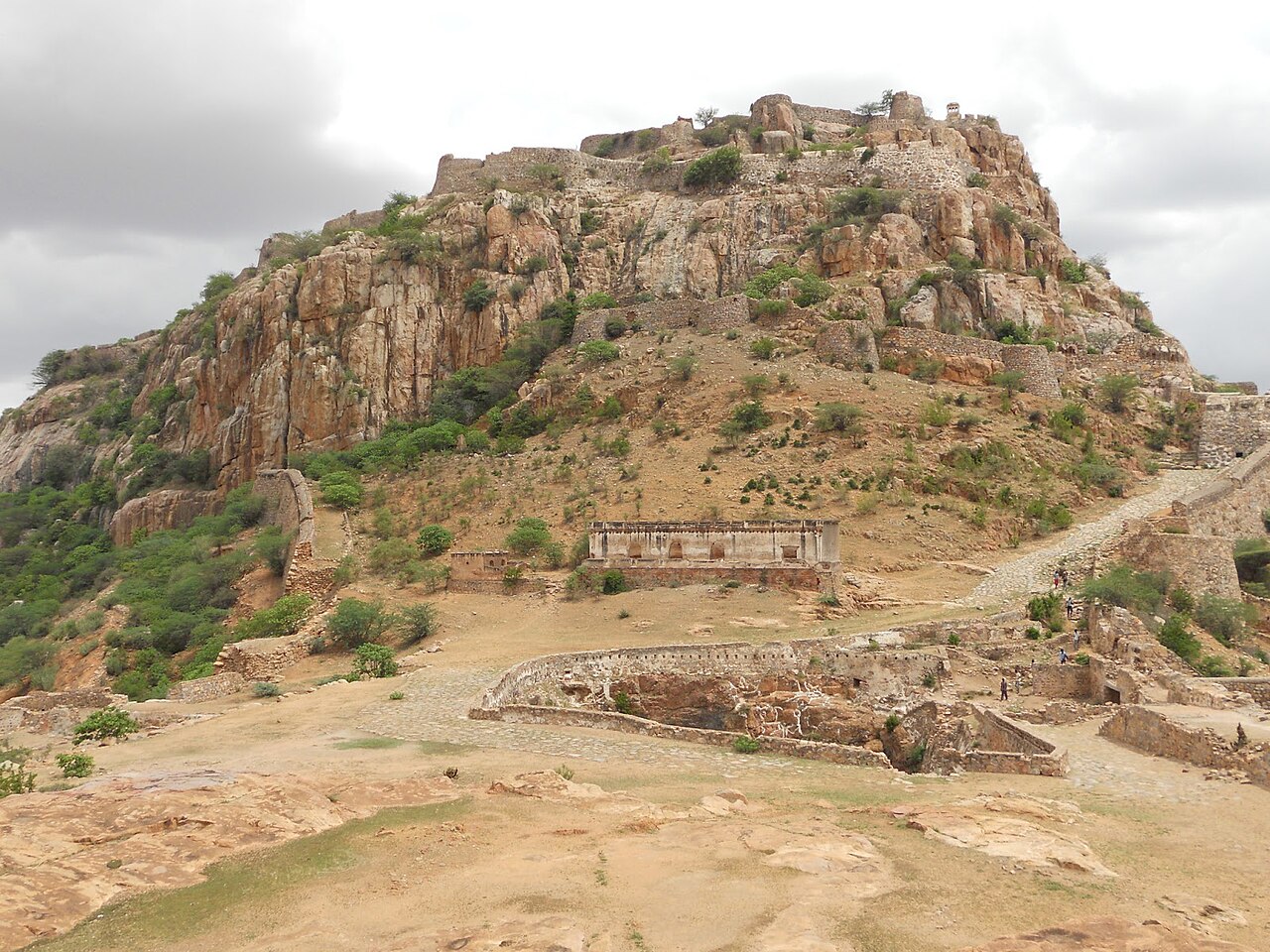
Raichur Fort is a significant bastioned fortress situated on a strategic hilltop overlooking the city of Raichur in the Raichur Doab region of North Karnataka, India. Constructed in the 13th century, this fortress has played a pivotal role in the military and political history of the Deccan region, serving as a stronghold for various powerful dynasties over several centuries.

Historical significance and ruling dynasties

The Raichur region, known as the Raichur Doab—the fertile land between the rivers Krishna and Tungabhadra—has been a coveted territory due to its agricultural wealth and strategic location. The fort itself has witnessed the rise and fall of several prominent dynasties, including the Kakatiya dynasty, the Rashtrakutas, the Vijayanagar Empire, the Bahmani Sultanate, and the Nizams of Hyderabad.

Each ruling power left its mark on the fort’s structure and defenses, adapting it to the evolving demands of warfare. The Kakatiyas are credited with early fortifications in the region, while the Vijayanagar Empire expanded and reinforced the fort during their reign in the 14th to 16th centuries. The Bahmani Sultanate and later the Nizams further enhanced the bastions and walls to withstand artillery attacks, reflecting the transition to gunpowder warfare.

Architectural features and fortifications

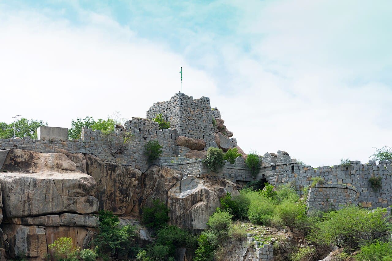
Raichur Fort exemplifies the bastioned fortress style, characterized by robust stone walls reinforced with massive bastions at strategic points. These bastions provided platforms for mounting cannons and other artillery, which were crucial for defense during the High Medieval and later periods.

The fort’s layout is adapted to the natural contours of the hilltop, incorporating multiple gates, ramparts, and watchtowers that allowed defenders to monitor and repel enemy advances effectively. The walls are thick and angled to deflect cannonballs, a feature added during the later modifications by the Bahmani and Nizam rulers.

Inside the fort, there are remnants of palatial structures, barracks, and water reservoirs that supported prolonged sieges. The presence of a mosque within the fort complex reflects the Islamic influence during the Bahmani and Nizam periods.

Strategic location and military importance

Positioned on a commanding hill, Raichur Fort controlled the critical trade and military routes across the Raichur Doab. Its location allowed for surveillance over the surrounding plains and river valleys, making it a key defensive outpost in the Deccan region.

The fort’s control was often contested due to its strategic importance, leading to numerous battles and sieges. Notably, it played a role in the conflicts between the Vijayanagar Empire and the Bahmani Sultanate, which fought for dominance over the fertile Raichur Doab.

Preservation and current condition

Today, Raichur Fort stands as a well-preserved monument, although some parts have suffered from natural erosion and neglect over time. Restoration efforts have focused on maintaining the structural integrity of the bastions and walls, allowing visitors to appreciate the fort’s imposing scale and historical significance.

The fort is accessible to tourists and history enthusiasts, offering panoramic views of the surrounding landscape and insights into the military architecture of medieval India.

Cultural and heritage importance

Raichur Fort is not only a military relic but also a symbol of the region’s diverse cultural history. The amalgamation of Hindu and Islamic architectural elements within the fort reflects the syncretic heritage of the Deccan. It serves as a reminder of the complex political dynamics and cultural exchanges that shaped South Indian history.

Frequently asked questions (FAQ)

How do I get to Raichur Fort?
Raichur Fort is located in the city of Raichur, Karnataka, India. You can reach the fort by taking a bus or hiring a taxi from nearby cities like Hyderabad or Bangalore. The nearest railway station is Raichur Junction, which is well-connected to major cities.
What is the historical significance of Raichur Fort?
Raichur Fort has a rich history dating back to the 15th century and has been ruled by various dynasties, including the Rashtrakutas and the Bahmani Sultanate. It played a crucial strategic role in regional politics and served as a military stronghold. The fort's architecture reflects the influence of these dynasties and their conflicts.
When was Raichur Fort built?
Raichur Fort was constructed in the 14th century, with significant modifications made in the 15th century. The fort has witnessed various battles and has been an important center of power in South India. Its construction showcases the military architecture of that era.
Can I explore the fort on my own?
Yes, visitors can explore Raichur Fort independently. However, guided tours are also available for those interested in learning more about its history and architecture. Be sure to wear comfortable shoes for walking around the fort's expansive grounds.
Why is Raichur Fort a popular tourist attraction?
Raichur Fort is popular for its stunning architecture, panoramic views of the surrounding landscape, and rich historical context. It attracts history enthusiasts, architecture lovers, and nature photographers. The fort's well-preserved structures and scenic surroundings make it an ideal spot for a day trip.
Is it possible to visit Raichur Fort year-round?
Yes, Raichur Fort is open year-round for visitors. However, the best time to visit is during the winter months, from October to February, when the weather is cooler and more pleasant for exploration. Summer can be quite hot, while the monsoon season may limit outdoor activities.
What are the opening hours of Raichur Fort?
Raichur Fort is typically open to visitors from 9 AM to 6 PM daily. It’s advisable to check local guidelines for any changes in hours or special events that may affect access. Visiting during the early morning or late afternoon can enhance your experience with fewer crowds.
What are the ticket prices for Raichur Fort?
Entry to Raichur Fort is generally free for all visitors, making it an accessible attraction for everyone. However, if you opt for a guided tour, there may be a nominal fee. Always check for any updates regarding fees or charges before your visit.
Are there any nearby attractions to visit?
Yes, there are several attractions near Raichur Fort, including the Raichur Fort Lake and the ancient temples in the area. The city of Raichur itself offers a glimpse into local culture and history. Exploring these sites can enrich your visit and provide a fuller experience of the region.

Photo gallery

Raichur Fort
Click to view

Photo by Madhu B M•CC BY-SA 4.0

1 photo • Click any image to view in full screen

Information

Bastioned Fortress

Loading map...

Visitor reviews

No reviews yet. Been here? Write the first review and help other travelers!

Write the first review

Visited this castle? Share your experience

Your review helps other travelers and adds first-hand knowledge to our encyclopedia.
Write a review

(5/5)

0/2000 characters

Your review will be visible after admin approval

Nearby castles

83.2 km
Konda Reddy Fort — India castle

Konda Reddy Fort

Kurnool, India

Konda Reddy Fort, also known as Kondareddy Buruju, stands as a significant historical bastioned fortress in the city of Kurnool, located in the state of Andhra Pradesh, India. This fort is situated approximately 2 kilometers from the Kurnool Railway Station and 2.9 kilometers from the Kurnool New Bus Stand, making it easily accessible to visitors. It lies about 24 kilometers from Alampur, a town known for its ancient temples. The fort occupies a central position within Kurnool city, marking it as a notable landmark. The fort's most distinctive feature is its semi-circular bastion, which is crowned by a tower, representing the only surviving structure from the original fortifications that once encircled the city. This bastioned design reflects military architectural principles aimed at defense and surveillance, characteristic of fortifications built to withstand artillery assaults. Historical context and significance Konda Reddy Fort is named after a local ruler or chieftain, believed to be Konda Reddy, who played a role in the region's history during the late medieval period. The fort's origins date back several centuries, with its construction reflecting the strategic importance of Kurnool as a center of administration and military activity in the region. The fortification served as a defensive stronghold in various historical conflicts and witnessed the changing control of the Deccan region, including the influence of the Vijayanagara Empire and later the Qutb Shahi dynasty. Its bastioned walls were designed to repel invaders and protect the inhabitants of the city. Architectural features and layout The surviving semi-circular bastion of Konda Reddy Fort is a prominent example of bastioned fort architecture, which integrates angular bastions for improved defense. This architectural style became widespread in India during the late medieval period as gunpowder weaponry became more prevalent. The fort's walls, originally encompassing a larger area, were constructed using locally sourced stone and lime mortar. The bastion's elevated tower provided vantage points for lookouts to monitor approaching threats. Although much of the original fortification has been lost over time, the existing structure offers insight into the military engineering techniques employed. Defensive elements The bastion was designed to allow defenders to fire upon enemies from multiple angles, minimizing blind spots. The thick walls and elevated position enhanced its resilience against artillery fire. The tower atop the bastion served both as a lookout and a command post during sieges. Current condition and preservation Today, Konda Reddy Fort remains a well-preserved monument, although only the bastioned portion survives intact. The fort is maintained as a heritage site and attracts tourists interested in the military history and architecture of Andhra Pradesh. Efforts have been made to conserve the structure, and it is an important cultural symbol for the city of Kurnool. The fort's central location within the urban environment presents challenges for preservation but also ensures its visibility and accessibility to the public. Visiting information Visitors to Konda Reddy Fort can explore the bastion and tower, gaining views of the surrounding cityscape. The site is open to the public, and its proximity to major transport hubs makes it convenient for tourists and locals alike. The fort is an ideal destination for those interested in medieval military architecture and the historical evolution of fortifications in southern India. Nearby attractions such as the temples of Alampur provide additional cultural context for visitors.

Late Medieval (14th–15th c.)
Details
124.5 km
Gooty Fort — India castle

Gooty Fort

Gooty, India

Gooty Fort, also known as Ravadurg and Gutti Kota, is an ancient hilltop fortress located in the town of Gooty in the Anantapur district of Andhra Pradesh, India. This fort is perched atop a rocky hill, strategically positioned to oversee the surrounding plains, which historically made it a formidable defensive stronghold. The fort's location on a steep hill provided natural protection, complemented by man-made fortifications that enhanced its defensive capabilities.The fort is recognized as a centrally protected monument of national importance by the Archaeological Survey of India, highlighting its cultural and historical significance within the region. Although now in a state of ruins, the remnants of the fort reveal insights into the military architecture and strategic planning of the period in which it was constructed.Historical background and significanceGooty Fort has a history that dates back several centuries, with its origins linked to various ruling dynasties in southern India. It was an important military and administrative center during the medieval period. The fort changed hands multiple times due to its strategic importance, including control by the Vijayanagara Empire, Qutb Shahi dynasty, and later the Mughal Empire. Each ruling power contributed to the fort's construction and modifications, reflecting a blend of architectural influences.The fort's prominence was largely due to its commanding position over trade routes and its role in regional power struggles. Its control was vital for dominance in the Deccan region, making it a coveted military asset during various conflicts and sieges.Architectural features and layoutThe fort is an example of hill fort architecture typical of the Deccan region, utilizing the natural topography to create a strong defensive position. The fortifications include massive stone walls that follow the contours of the hill, enclosing an extensive area with multiple levels of defense.Key architectural elements include:Ramparts and bastions: Thick stone walls with bastions at strategic intervals provided vantage points for archers and artillery.Gates and entrances: The fort features several fortified gateways designed to control access and slow enemy advances.Water management systems: Cisterns and tanks were carved into the rock to collect and store rainwater, essential for sustaining the garrison during sieges.Inner citadel: The highest point of the fort housed the citadel, which served as the last line of defense and contained the ruler's quarters and armory.Despite its ruined state, the fort's layout still reveals a complex design aimed at maximizing defense and sustainability in a hostile environment.Current condition and preservation effortsToday, Gooty Fort stands as ruins, with many of its structures partially collapsed due to centuries of neglect and natural erosion. The fort's stone walls, gateways, and some bastions remain visible, offering visitors a glimpse into its past grandeur.The Archaeological Survey of India has undertaken measures to preserve the site as a protected monument. Efforts focus on stabilizing remaining structures and preventing further deterioration. However, the fort is largely an archaeological site requiring careful conservation to maintain its historical fabric.Visiting information and cultural importanceThe fort is accessible to visitors who can explore its extensive ruins and enjoy panoramic views of the surrounding landscape. It attracts history enthusiasts, researchers, and tourists interested in medieval Indian forts and architecture.Gooty Fort holds cultural significance as a symbol of the region's rich historical heritage and military past. It serves as a reminder of the strategic importance of hill forts in India's history and the architectural ingenuity of its builders.

Late Medieval (14th–15th c.)
Details
171.6 km
Golconda — India castle

Golconda

Hyderabad, India

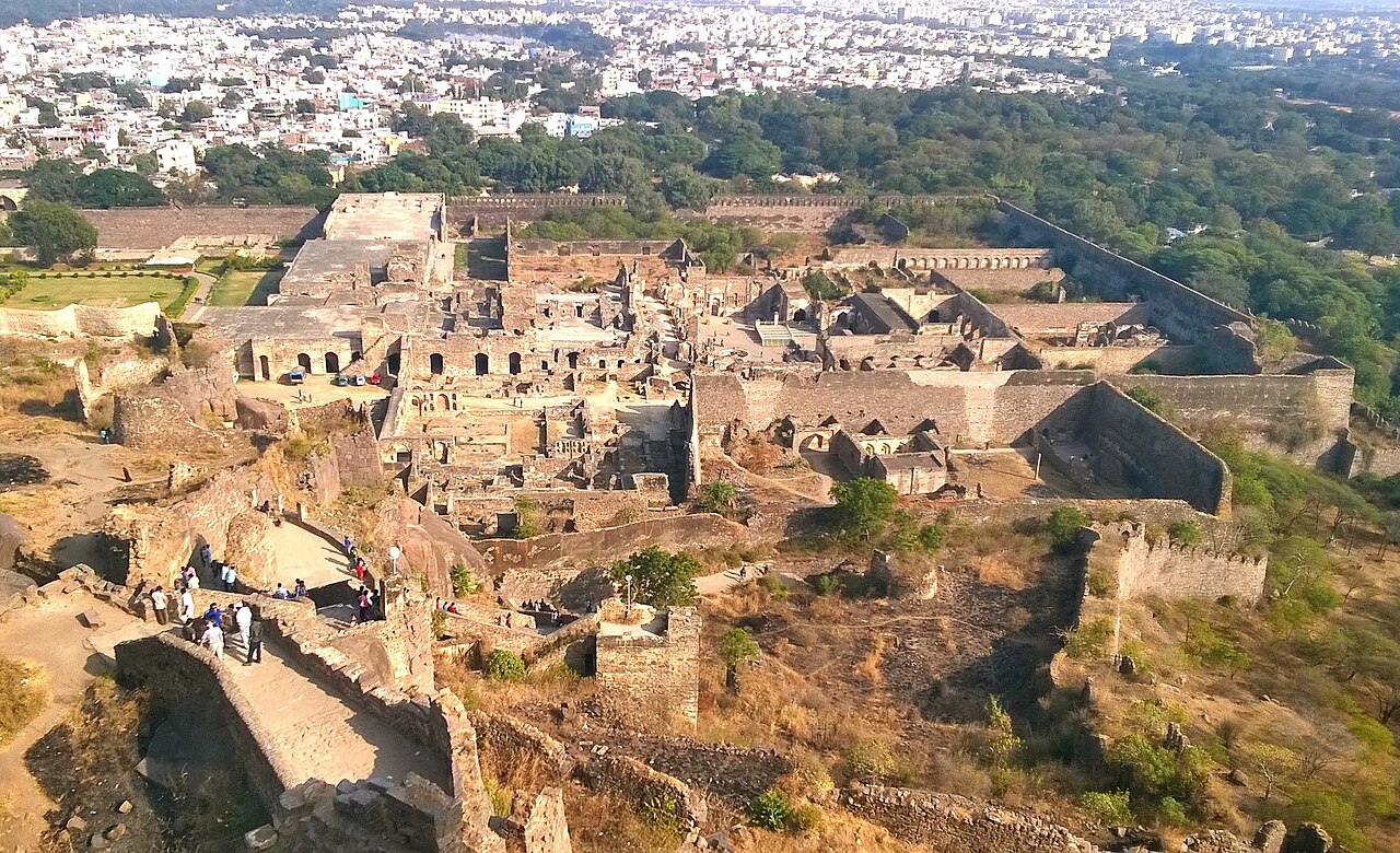
Golconda Fort is a monumental fortified citadel and the ruins of a once-thriving city located on the western outskirts of Hyderabad, Telangana, India. This historic fortress stands as a significant example of medieval military architecture in the Deccan region. Originally constructed in the 12th century by the Kakatiya dynasty, led by ruler Pratāparudra, the fort began as a modest mud-walled stronghold. Over the centuries, it evolved into a massive defensive complex with stone fortifications that reflect the region's changing political and cultural landscape. Early history and architectural evolution The initial construction of Golconda Fort dates back to the late 11th and early 12th centuries, when the Kakatiya rulers established it as a strategic military post. The original fortifications were primarily built using mud walls, which were later replaced by more durable stone structures. The fort's location on a granite hill provided a natural defensive advantage, enabling it to control the surrounding plains and trade routes effectively. Following the decline of the Kakatiya dynasty in the 14th century, Golconda came under the control of the Musunuri Nayakas. During this period, the fort's defenses were strengthened to withstand the increasing threats from neighboring kingdoms. In the mid-14th century, the fort was ceded to the Bahmani Sultanate during the reign of Mohammed Shah I, a pivotal moment that marked the beginning of Golconda's transformation into a major political and military center. Golconda under the deccan sultanates With the fragmentation of the Bahmani Sultanate into five smaller sultanates, Golconda emerged as the capital of the Sultanate of Golconda under the leadership of Sultan Quli Qutb-ul-Mulk. Appointed as governor by the Bahmani rulers, Sultan Quli fortified the city extensively, expanding its walls, gates, and bastions to create a formidable fortress. The architectural style during this period combined indigenous Indian elements with Persian and Islamic influences, resulting in a unique blend that characterizes the Deccan Sultanate's heritage. The fort complex includes massive defensive walls, multiple gates such as the famous Fateh Darwaza (Victory Gate), and a series of watchtowers and bastions designed for optimal defense. The internal layout comprises royal palaces, mosques, audience halls, and a network of water supply systems, including large reservoirs and aqueducts that ensured the fort's sustainability during sieges. Golconda's role in diamond trade and economic significance Golconda Fort gained international fame for its proximity to some of the world's richest diamond mines, notably the Kollur Mine. The region was renowned for producing the legendary Golconda diamonds, which included some of the most famous gems in history such as the Koh-i-Noor and the Hope Diamond. This lucrative diamond trade brought immense wealth to the sultanate and attracted merchants and traders from across Asia and Europe. The fort's strategic location along important trade routes facilitated the exchange of goods, culture, and ideas. The economic prosperity of Golconda during the 16th and 17th centuries is reflected in the grandeur of its architectural remains and the sophistication of its urban planning. Architectural features and defensive innovations Golconda Fort is notable for its advanced military architecture, which includes a series of concentric walls, strategically placed bastions, and an ingenious acoustic system that allowed sounds made at the entrance gate to be heard at the highest point of the fort. This early warning system was designed to alert the inhabitants of any approaching danger. The fort's massive gates are adorned with intricate carvings and inscriptions, showcasing the artistic achievements of the Deccan Sultanate period. The complex also features a network of underground tunnels and chambers used for storage and as escape routes during attacks. Cultural and historical legacy Today, Golconda Fort stands as an archaeological site and a symbol of the rich cultural heritage of the Deccan region. Despite being in a state of ruins, the fort attracts numerous visitors interested in its history, architecture, and the legends surrounding its diamond trade. In 2014, Golconda Fort was placed on the UNESCO Tentative List under the designation "Monuments and Forts of the Deccan Sultanate" alongside other significant forts in the region. This recognition underscores the fort's importance as a cultural landmark and its potential for future conservation and study. Visiting golconda fort The site is accessible to tourists year-round, with the best time to visit being during the cooler months from October to March. Visitors can explore the extensive ruins, including the grand gates, royal chambers, and the famous sound and light show that narrates the fort's history in the evenings. Preservation challenges As an ancient fortification exposed to natural elements and urban encroachment, Golconda faces ongoing preservation challenges. Efforts by local authorities and heritage organizations aim to maintain the structural integrity of the remaining walls and promote awareness of the site's historical value.

High Medieval (11th–13th c.)
Details