Mseilha Fort
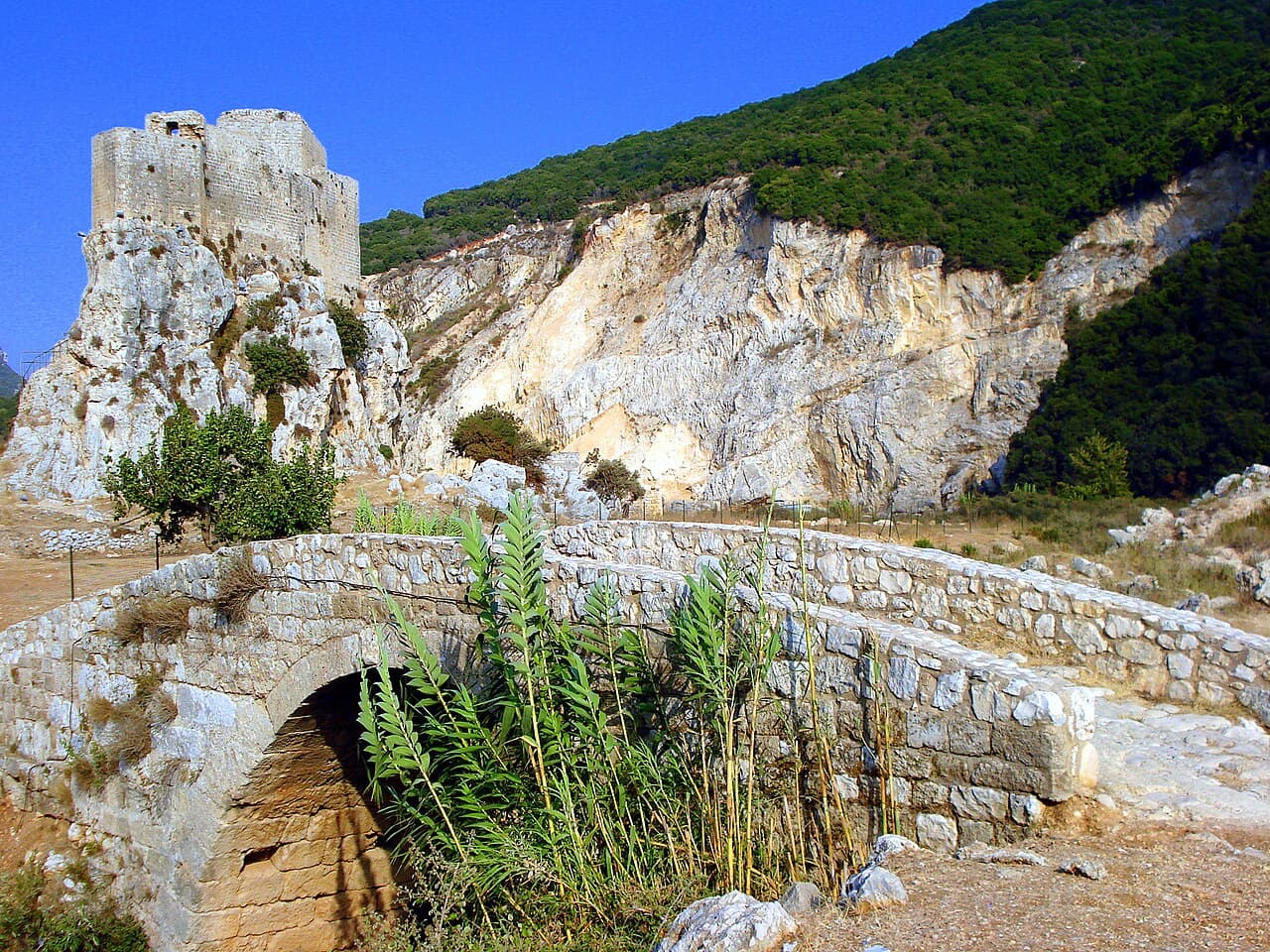
Mseilha Fort stands as a remarkable example of early 17th-century military architecture in northern Lebanon. Perched strategically on a narrow limestone ridge above the right bank of the Al-Jaouz River, about 2.5 kilometers northeast of Batroun, this hill castle was constructed to control a vital north-south passage linking the cities of Tripoli and Beirut. Its commanding position allowed the fort to oversee and regulate movement through the Nahr el-Jaouz valley, an essential corridor for trade and military logistics during the Ottoman period.
The current fortress was most likely commissioned around 1624 by Emir Fakhr al-Din II, a prominent Druze leader who ruled parts of the Lebanese mountains under Ottoman suzerainty. His initiative to build Mseilha Fort was part of a broader strategy to consolidate power and secure key routes in the region. The fort’s construction and subsequent restoration in 1631 by Sheikh Abu Nadir al-Khazin are well documented in local histories and traveler accounts, including those of Jean de La Roque and Father Mansur Tannus al-Hattuni.
Historical significance of the site predates the Ottoman era. Following the devastating earthquake of 551 CE that destroyed the coastal road along the Mediterranean, travelers were compelled to use a safer inland route through the valley. This elevated the strategic importance of the site, which likely hosted earlier fortifications during the Crusader period. Medieval chroniclers referred to earlier castles here by names such as Puy du Connétable or Castrum Constabularii, indicating a command post; however, no physical remains from these earlier structures survive in the current fort.
Architectural features and layout
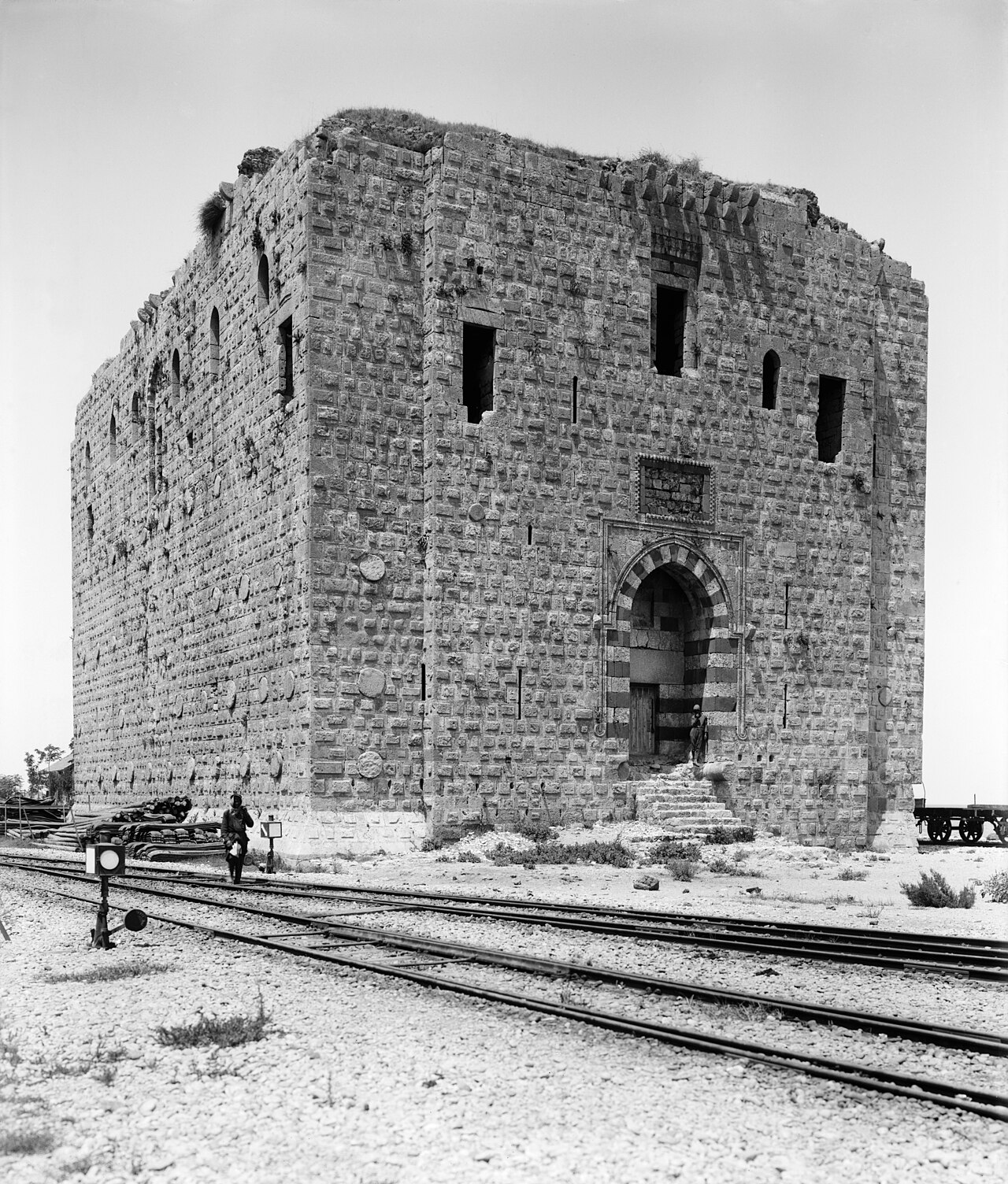
Mseilha Fort is built on a natural limestone outcrop, integrating the rocky terrain into its defensive design. The fortress covers approximately 500 square meters and rises to about 15 meters in height. It consists of two main adjoining sections constructed in successive phases, forming a unified complex that adapts to the contours of the ridge.
The walls are primarily constructed from medium-sized sandstone blocks quarried locally along the coast, with some larger limestone blocks incorporated, likely recycled from earlier buildings. These walls are notably thick, ranging from 1.5 to 2.5 meters, providing formidable protection against attack.
Access to the fort is via a narrow, steep path on the northern side, where steps are carved directly into the bedrock. These steps lead to a small masonry terrace in front of a low, rounded-arch doorway that serves as the main entrance. Beyond this gateway lies a sharply angled triangular courtyard.
Southern section and subterranean chambers
The southern side of the courtyard is bounded by a two-bay vaulted structure containing large underground vaulted chambers. These subterranean spaces functioned as storage areas and cisterns, critical for preserving supplies and collecting water during sieges. A small prayer niche, or mihrab, aligned toward the qibla, marks a designated prayer area for the garrison, reflecting the religious practices of the soldiers stationed here.
The southern walls are built approximately two meters higher than those on the northern side, an architectural adaptation to the elevated terrain that enhanced the fort’s defensive capabilities overlooking the valley entrance.
Defensive elements and eastern tower
Defensive features include narrow arrow slits located in the western tower’s archery chamber and in rooms on the upper floor of the eastern section, which is the most heavily fortified part of the complex. This eastern portion contains vaulted rooms arranged around a compact inner courtyard. A staircase here leads to an upper story and culminates in a projecting square tower at the easternmost tip of the fort, offering commanding views of the surrounding landscape.
Historical context and legacy
The fort’s construction during the early modern period reflects the strategic military needs of the Ottoman Empire in Lebanon, particularly under the leadership of Fakhr al-Din II. His efforts to fortify key locations helped secure his rule and protect important trade and communication routes. Despite its early modern origins, the site’s long history as a strategic point is underscored by references to earlier fortifications and its role following the 551 CE earthquake.
European travelers and scholars from the 19th and 20th centuries, such as Max von Berchem and Paul Deschamps, studied Mseilha Fort extensively, confirming its 17th-century construction and distinguishing it from Crusader castles by the absence of medieval architectural elements. The fort’s cultural and historical significance is recognized nationally, as evidenced by its depiction on Lebanon’s 25 Lira banknote during the mid-20th century.
Restoration and preservation efforts
In 2007, Mseilha Fort underwent significant restoration funded by international programs and supported by Lebanese authorities. These efforts focused on reinforcing the structure and preserving its surroundings, ensuring the fort remains a valuable heritage site. Today, the fort is well preserved, allowing visitors and scholars to appreciate its architectural features and historical importance.
The fort’s integration of natural topography with military architecture, its robust defensive walls, and its strategic location make it a compelling study in early modern fortification design. Its survival through centuries and careful restoration highlight its enduring significance in Lebanon’s cultural landscape.
Frequently asked questions (FAQ)
- How do I access Mseilha Fort?
- Access to Mseilha Fort is via a narrow, steep path on the northern side, with steps carved into the bedrock leading to the main entrance. Visitors should be prepared for a moderate climb and wear appropriate footwear.
- What is the historical significance of Mseilha Fort?
- Mseilha Fort was built in the early 17th century by Emir Fakhr al-Din II to secure the strategic Nahr el-Jaouz valley route. It played a key role in controlling movement between Tripoli and Beirut during the Ottoman period.
- Are there any remnants of Crusader architecture at Mseilha Fort?
- No physical remains of Crusader architecture survive at Mseilha Fort. Although earlier fortifications likely existed on the site during the Crusader period, the current structure dates from the early modern era and lacks medieval elements.
- When was Mseilha Fort restored?
- Significant restoration of Mseilha Fort took place in 2007, funded by international programs and supported by Lebanese authorities to preserve its structural integrity and historical value.
- What defensive features does Mseilha Fort have?
- The fort includes thick sandstone and limestone walls, narrow arrow slits for archers, vaulted underground chambers for storage and cisterns, and a projecting square tower for observation and defense.
Photo gallery

Information
Loading map...
Visitor reviews
No reviews yet. Been here? Write the first review and help other travelers!
Write the first reviewVisited this castle? Share your experience
Your review helps other travelers and adds first-hand knowledge to our encyclopedia.