Mini Castles in Vermont Town

Miniature stone castles of South Hero, Vermont

South Hero, a quaint island town in Vermont with fewer than 2,000 residents, is renowned for its enchanting collection of miniature stone castles. These charming structures, scattered across the town, provide a whimsical and fairytale-like atmosphere that contrasts beautifully with the town's modest size and rural setting. The castles have become a beloved local attraction and a testament to individual creativity and craftsmanship.

The castles were the brainchild of Harry Barber, a Swiss immigrant who settled in South Hero in the early 20th century. After losing part of a finger in a mining accident in his native Switzerland, Barber left Europe at the age of 21 and eventually made his way to North America. His journey ended in South Hero, where he married a local woman and established roots. Barber worked various jobs, primarily as a gardener, but his enduring legacy is the series of stone castles he built on the properties he tended.

The origin and inspiration behind the castles

Harry Barber's passion for creating these castles was deeply tied to his Swiss heritage. Inspired by the medieval fortresses of his homeland, he sought to recreate their charm and grandeur on a miniature scale. Each castle was constructed primarily from fieldstone, a readily available local material, which Barber skillfully shaped to mimic the rugged stone walls of traditional European castles.

The castles served not only as decorative garden features but also as personal tributes to Barber's past and a symbol of his craftsmanship. Their modest size belies the attention to detail and architectural elements Barber incorporated, making each castle unique.

Architectural features and unique elements

Despite their small scale, the castles boast a variety of authentic architectural details. Some feature drawbridges that add a playful interactive element, while others include glass windows and flags that enhance their visual appeal. Remarkably, a few of the castles are equipped with electrical wiring and even running water in the moat, showcasing Barber's ingenuity and dedication to creating functional as well as decorative structures.

The interiors of some castles contain long spiral staircases, which not only add to the medieval aesthetic but also demonstrate advanced masonry skills. These staircases allow visitors to explore the castles more fully, further immersing them in the miniature medieval experience.

Construction techniques

Barber employed traditional stone masonry methods, carefully selecting and fitting each stone to ensure structural stability and aesthetic harmony. The use of fieldstone gives the castles a rustic and authentic appearance, blending naturally with the surrounding landscape. The mortar and stonework reflect the craftsmanship typical of historic European castles, adapted to the smaller scale and the materials available in Vermont.

Cultural significance and local impact

The miniature castles quickly became a cherished part of South Hero's cultural landscape. Local residents embraced the structures, which contributed to the town's identity and charm. According to local lore, the castles were so beloved that they were sometimes used as bartering chips among residents, highlighting their value beyond mere decoration.

Today, the castles stand as a unique example of folk art and personal dedication, attracting visitors interested in both garden design and castle architecture. They serve as a reminder of the immigrant experience and the ways in which personal history and cultural heritage can be expressed through creative endeavors.

Visiting the miniature castles

Visitors to South Hero can explore these miniature stone castles scattered throughout the town. While the castles are on private properties and gardens, many owners welcome visitors to admire them from public vantage points or during special events. The castles offer a delightful experience for families, history enthusiasts, and anyone interested in unique architectural curiosities.

Exploring the castles provides insight into early 20th-century immigrant life in Vermont and showcases the blend of European influences with American rural settings. Their preservation and continued appreciation reflect the community's respect for Harry Barber's legacy and the artistic value of his work.

Best times to visit and accessibility

The castles are best viewed during the warmer months when gardens are in full bloom, enhancing the fairy-tale ambiance. South Hero's small size makes it easy to explore on foot or by bicycle, allowing visitors to enjoy the scenic beauty of the island alongside the architectural marvels.

While the castles themselves are miniature and some are on private land, the town encourages respectful visitation and offers opportunities to learn about the history and significance of these stone fortresses.

Legacy of harry barber and preservation efforts

Harry Barber's dedication to building these miniature castles has left a lasting mark on South Hero. His work is celebrated as a unique blend of personal history, architectural skill, and cultural homage. Preservation efforts by local residents and historical societies aim to maintain the castles' condition and promote awareness of their significance.

The castles continue to inspire local artists and gardeners, serving as a symbol of creativity and the enduring influence of cultural heritage in shaping community identity.

Frequently asked questions (FAQ)

What is the historical significance of This Small Vermont Town Has a Gorgeous Collection of Mini Castles?
This collection of mini castles in South Hero reflects the unique architectural heritage and artistic vision of the region. Built primarily in the early 20th century, these structures showcase the creativity and craftsmanship of local builders and serve as a charming reminder of Vermont's rich history.
When is the best time to visit the mini castles in South Hero?
The best time to visit is during the late spring through early fall when the weather is pleasant and the gardens surrounding the castles are in full bloom. Additionally, many local events and festivals occur during these months, enhancing the overall experience for visitors.
Can I access the mini castles for free?
Access to the mini castles may vary; some might have free entry while others could charge a nominal fee for guided tours. It’s advisable to check the specific castle’s website or contact local tourism information for accurate details regarding any admission costs.
What are the opening hours for visiting the mini castles?
The opening hours for the mini castles typically vary by season, with longer hours during summer months. Generally, they tend to be open from late morning until early evening, but it's best to confirm specific hours prior to your visit to ensure a smooth experience.
Is it possible to take photographs inside the mini castles?
Photography policies can differ from one castle to another, but many do encourage visitors to capture the beauty of the architecture and surroundings. However, it’s wise to check for any restrictions or guidelines upon arrival to respect the site’s regulations.
Are there any nearby attractions worth visiting along with the mini castles?
Yes, South Hero is home to several nearby attractions, including beautiful Lake Champlain, scenic biking trails, and local wineries. Combining a visit to the mini castles with these attractions makes for a delightful day exploring the natural beauty and culture of the area.
How do I get to South Hero to visit the mini castles?
South Hero is accessible by car, located about 30 minutes from Burlington, Vermont. Public transportation options may be limited, so driving or arranging for a ride is often the most convenient way to reach the town and its mini castles.
What type of architecture can I expect to see at the mini castles?
The mini castles feature a variety of architectural styles, often inspired by medieval European designs. Visitors can expect to see intricate stonework, whimsical towers, and charming details that create a fairy-tale atmosphere throughout the collection.

Loading map...

Visitor reviews

No reviews yet. Been here? Write the first review and help other travelers!

Write the first review

Visited this castle? Share your experience

Your review helps other travelers and adds first-hand knowledge to our encyclopedia.
Write a review

(5/5)

0/2000 characters

Your review will be visible after admin approval

Nearby castles

69.3 km
Fort Saint-Frédéric — United States of America castle

Fort Saint-Frédéric

Crown Point, United States of America

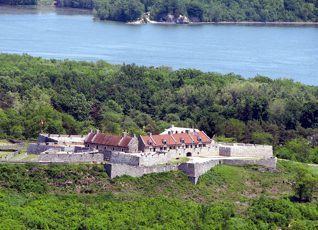
Fort Saint-Frédéric was a significant French bastioned fortress constructed in the early 18th century on the western shore of Lake Champlain, in what is now Crown Point, New York. Its primary purpose was to secure the region against British colonial expansion and to control the vital waterway that connected the Canadian territories with the British colonies to the south. Construction began in 1734, under French colonial authorities aiming to establish a strong military presence in the contested borderlands between New France and the British colonies. Strategic location and military role The fort's position on Lake Champlain was of immense strategic importance. The lake served as a major corridor for movement of troops and supplies during the colonial conflicts between France and Britain. Fort Saint-Frédéric was situated at a narrow point on the lake, allowing the French to monitor and control naval traffic effectively. This location was critical in maintaining French influence over the region and preventing British incursions into New France. Architectural design and features Fort Saint-Frédéric exemplified the bastioned fortress style typical of the post-Renaissance military architecture influenced by the principles of Sébastien Le Prestre de Vauban, the famous French military engineer. The fort featured thick stone walls arranged in a square with four bastions at each corner. These bastions allowed defenders to cover all approaches with overlapping fields of fire, a key advancement in fortification design that enhanced defensive capabilities against artillery and infantry assaults. The walls were constructed of limestone, quarried locally, and were several feet thick to withstand cannon fire. Inside, the fort included barracks, powder magazines, officers' quarters, and storage facilities. The layout was compact but efficient, designed to house a garrison capable of defending the position against a sizeable attacking force. Historical context and military engagements Despite its formidable design, Fort Saint-Frédéric was never directly attacked during its operational period. However, it played a crucial role during the French and Indian War (1754–1763), serving as a base for French military operations in the region. The fort's presence deterred British advances along Lake Champlain for many years. In 1759, facing the approach of a large British army commanded by General Jeffery Amherst, the French garrison destroyed the fort to prevent its capture. This scorched earth tactic was common in colonial warfare to deny the enemy strategic assets. Legacy and preservation Following the destruction of Fort Saint-Frédéric, the British constructed the much larger Fort Crown Point adjacent to the ruins. Fort Crown Point was an extensive earthen fortress and became the largest such fortification in the American colonies. It too never saw major combat but was captured by American forces early in the American Revolutionary War. Today, the ruins of Fort Saint-Frédéric and Fort Crown Point are preserved within the Crown Point State Historic Site, established in 1910. Both sites have been recognized as National Historic Landmarks, reflecting their importance in early American and colonial military history. Visitors can explore the remains of the stone walls and bastions of Fort Saint-Frédéric, gaining insight into the military architecture and colonial conflicts of the 18th century. Architectural significance in colonial america Fort Saint-Frédéric stands as an early example of European bastioned fortification design adapted to the North American frontier. Its construction demonstrated the French commitment to securing their territorial claims through advanced military engineering. The fort's design influenced subsequent fortifications in the region, including British-built Fort Crown Point. The use of stone masonry and bastions reflected the transition from medieval castle designs to modern military fortresses capable of withstanding artillery bombardment. This architectural evolution was critical in the colonial context, where control of waterways and strategic points was essential for empire building. Visiting fort saint-frédéric today Visitors to the Crown Point State Historic Site can explore the ruins of Fort Saint-Frédéric alongside Fort Crown Point. Interpretive signage and guided tours provide historical context about the fort's construction, military role, and eventual destruction. The site offers panoramic views of Lake Champlain and the surrounding landscape, illustrating why this location was so strategically chosen. The ruins are accessible year-round, with facilities for visitors including walking trails and picnic areas. The site is managed by the New York State Office of Parks, Recreation and Historic Preservation, ensuring its preservation for future generations.

Post-Renaissance (17th–18th c.)
Details
89.4 km
Fort Chambly — Canada castle

Fort Chambly

, Canada

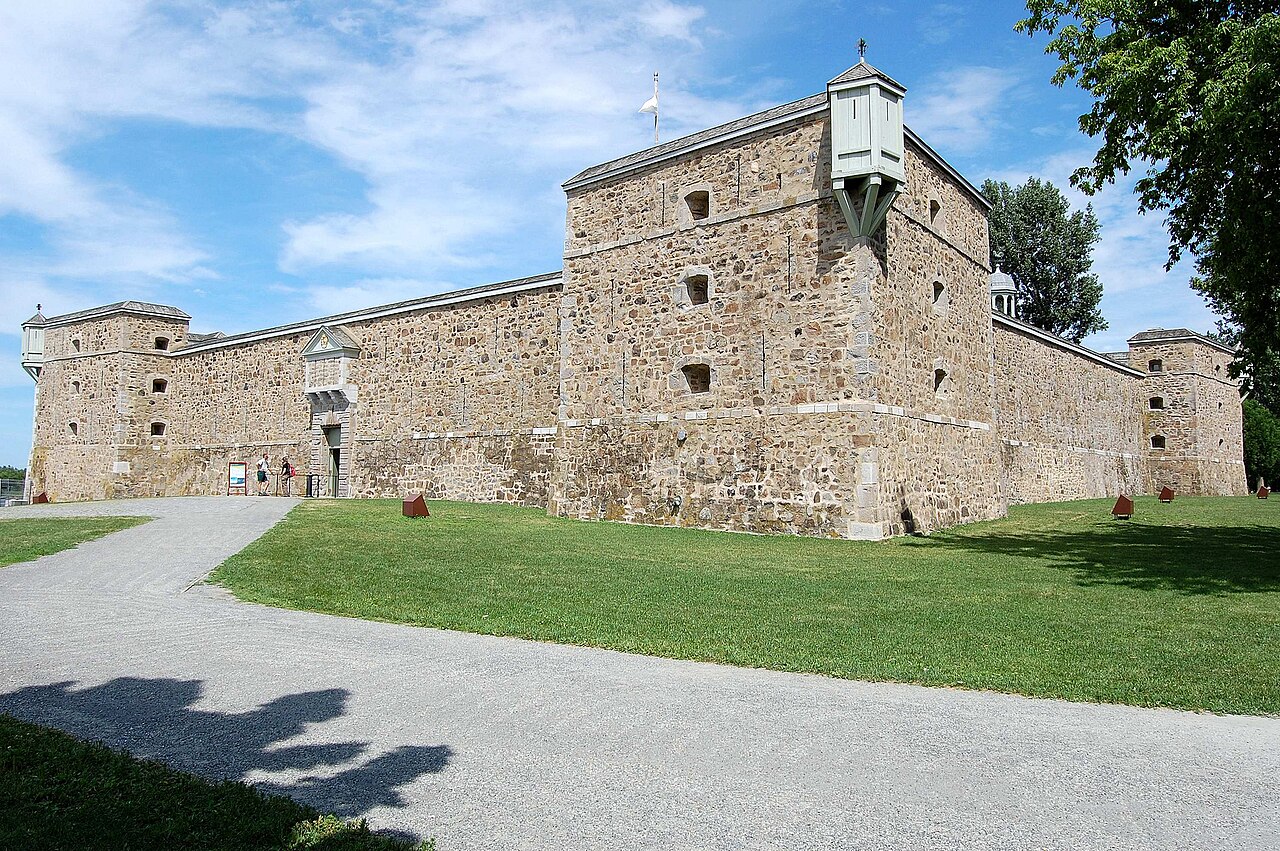
Fort Chambly, located in the La Vallée-du-Richelieu Regional County Municipality of Quebec, Canada, is a significant historic military structure originally constructed in the 17th century. Known formerly as Fort St. Louis, it served as a critical defensive bastion for French colonial interests during the period of New France. Strategically positioned along the Richelieu River, the fort was part of a network of five fortifications designed to protect travelers and settlers from attacks by the Iroquois Confederacy. This area is often referred to as la Vallée-des-Forts due to the concentration of these military installations. Historical context and construction The fort's origins date back to the early 1660s when the French colonial authorities recognized the need to secure the Richelieu River corridor, a vital route for trade and military movements between the Saint Lawrence River and the interior of the continent. The initial fortification was a wooden structure built under the direction of Captain Jacques de Chambly, from whom the fort takes its name. The current stone structure was constructed later, reflecting advancements in military architecture and the need for more durable defenses. Role in New France's defense system Fort Chambly was integral to the defense strategy of New France, serving as a bulwark against frequent raids by the Iroquois. It guarded the southern approach to Montreal and helped control navigation along the Richelieu River. The fort's placement allowed French forces to monitor and restrict access to the interior, protecting settlements and trade routes. Architectural features and design The fort is classified as a bastioned fortress, a style characteristic of the Renaissance military architecture that emphasized angular bastions projecting from the walls. These bastions allowed defenders to cover adjacent walls with crossfire, eliminating blind spots. The design of Fort Chambly incorporates these principles, with stone walls and bastions arranged to maximize defensive capabilities. Structural elements Bastions: Four prominent bastions at the corners provide overlapping fields of fire. Stone walls: Thick masonry walls built to withstand artillery attacks. Moat: A surrounding ditch enhanced the fort's defense against direct assaults. Gatehouse: A fortified entrance controlling access to the interior. Interior buildings: Barracks, powder magazines, and officers' quarters arranged within the walls. Later history and preservation After its initial military use, Fort Chambly saw various modifications and periods of occupation, including during the British conquest of New France in the 18th century. It was used intermittently by British forces and later Canadian authorities. The fort eventually fell out of military use and was preserved as a historic site. Modern status Today, Fort Chambly is designated as a National Historic Site of Canada. It is well preserved and open to the public as a museum and cultural heritage site. Visitors can explore the fort's bastions, walls, and interior structures to gain insight into 17th-century military architecture and colonial history. The site also hosts educational programs and reenactments that highlight its historical significance. Significance in Canadian heritage Fort Chambly represents an important chapter in Canada's colonial past, illustrating the military and strategic challenges faced by French settlers. Its preservation offers valuable lessons on fortification design during the Renaissance period and the complex interactions between European colonists and Indigenous peoples. The fort remains a key attraction for those interested in military history, architecture, and early Canadian settlement.

Renaissance (15th–17th c.)
Details
89.6 km
Fort Ticonderoga — United States of America castle

Fort Ticonderoga

, United States of America

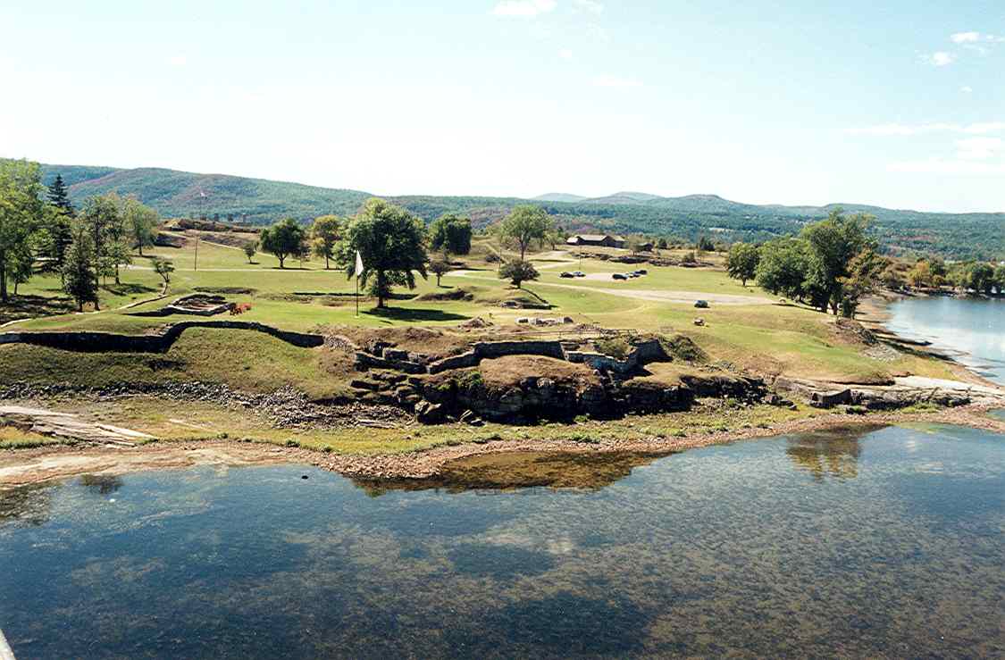
Fort Ticonderoga, originally named Fort Carillon, is a prominent 18th-century star fort located near the southern end of Lake Champlain in northern New York. Constructed between October 1755 and 1757 by the French-Canadian military engineer Michel Chartier de Lotbinière, Marquis de Lotbinière, it played a crucial role in the French and Indian War, the North American theater of the Seven Years' War. The fort's design reflects the bastioned fortress style prevalent in the post-Renaissance period, featuring angled bastions optimized for defense against artillery. The fort's strategic position controlled a vital river portage at the mouth of the rapid La Chute River, linking Lake Champlain and Lake George over a distance of approximately 3.5 miles (5.6 km). This location was essential for controlling trade and military movements between the British-controlled Hudson River Valley and the French-controlled Saint Lawrence River Valley. The surrounding Appalachian Mountains and the orientation of the lakes created natural barriers, making the narrow corridor commanded by Fort Ticonderoga a critical chokepoint in the region. Architectural design and features The fort exhibits the characteristics of a bastioned fortress, a design that emerged in Europe during the post-Renaissance era to counter the increasing power of cannon fire. Its layout includes star-shaped bastions that project outward from the main walls, allowing defenders to cover all approaches with overlapping fields of fire. The fort's walls were constructed with thick earthworks faced with stone, designed to absorb and deflect artillery bombardment. The main fortification includes several bastions, curtain walls, and a well-planned network of internal structures such as barracks, magazines, and powder stores. The fort's design prioritized both defense and the accommodation of a sizable garrison, reflecting its importance as a military stronghold in the contested borderlands of colonial North America. Historical significance in colonial conflicts Fort Ticonderoga was central to several key military engagements during the mid-18th century. The Battle of Carillon in 1758 saw approximately 4,000 French defenders successfully repel a much larger British force of around 16,000 troops. This victory underscored the fort's formidable defenses and strategic value. However, in 1759, the British returned with a reinforced army and captured the fort after the French garrison withdrew. The fort then became a British stronghold during the lead-up to the American Revolutionary War. Role in the american revolutionary war At the start of the Revolutionary War, Fort Ticonderoga was under British control. On May 10, 1775, it was seized by the Green Mountain Boys and other militia forces led by Ethan Allen and Benedict Arnold. This capture was significant for the American cause, as it provided a cache of artillery and a strategic position. Henry Knox famously transported the fort's artillery overland to Boston during the winter of 1775-1776, enabling the Continental Army to force the British evacuation of the city in March 1776. The Americans held the fort until June 1777, when the British under General John Burgoyne occupied the high ground above it, compelling an American withdrawal. In September 1777, a direct attack on the fort by about 500 American troops led by John Brown was unsuccessful against a smaller British garrison. Following the failure of the British Saratoga campaign, the fort was abandoned by the British and lost military importance. Post-war history and preservation After the Revolutionary War, Fort Ticonderoga fell into disuse and disrepair. Local residents scavenged building materials, and the fort was largely neglected. In 1820, it was purchased by a private family and gradually became a tourist destination, attracting visitors interested in its rich history. During the early 20th century, private owners undertook significant restoration efforts to preserve the fort's structure and historical integrity. Today, the Fort Ticonderoga Association manages the site as a museum, research center, and tourist attraction, offering educational programs and maintaining the fort's legacy as a symbol of colonial and Revolutionary War history. Geographical and cultural context The name "Ticonderoga" derives from the Iroquois word tekontaró:ken, meaning "it is at the junction of two waterways," highlighting the site's importance as a crossroads between major water routes. The fort's location in the narrow corridor between Lake Champlain and Lake George made it a focal point for control over the surrounding region during the colonial era and beyond. Today, Fort Ticonderoga stands as a well-preserved example of post-Renaissance military architecture in North America and remains a testament to the complex history of European colonization, indigenous presence, and the struggle for American independence.

Post-Renaissance (17th–18th c.)
Details