Fort Tigné — Malta castle

Fort Tigné

Fort Tigné: historic bastioned fortress in Malta
Sliema, Malta
Post-Renaissance (17th–18th c.)
Well Preserved

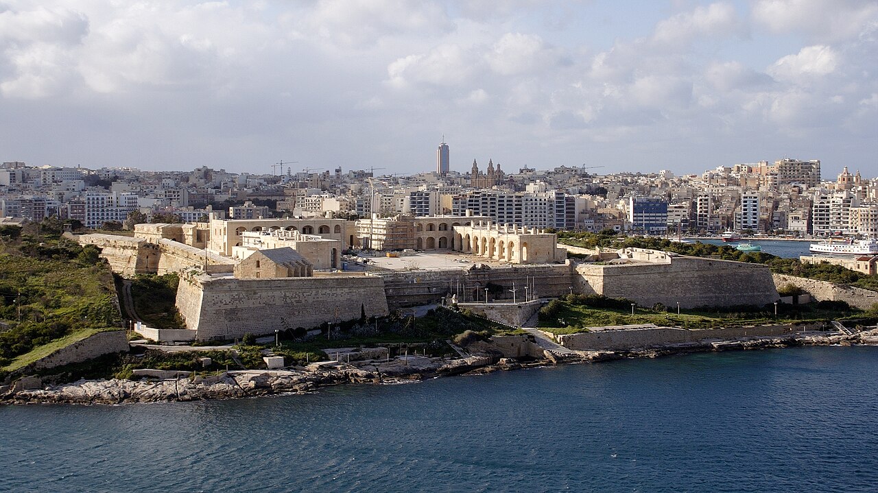
Fort Tigné (Maltese: Il-Forti Tigné or Il-Fortizza ta' Tigné) is a significant bastioned fortress located on Tigné Point in Sliema, Malta. Constructed between 1793 and 1795 by the Order of Saint John, it was designed to protect the strategic entrance to Marsamxett Harbour. Fort Tigné is notable for being one of the earliest examples of a polygonal fort in the world, marking a transition in military architecture from traditional bastioned designs to more modern fortification concepts.

Historical context and strategic importance

During the late 18th century, the Order of Saint John recognized the need to strengthen Malta's coastal defenses in response to evolving military threats and artillery technology. The location at Tigné Point was critical as it guarded one of the main entrances to the harbors of Malta, alongside Fort Manoel and Fort Saint Elmo. Fort Tigné's construction was part of a broader effort to modernize the island's fortifications amid increasing European conflicts.

Architectural design and innovations

The fort's design is a compact, polygonal shape, differing from the traditional star-shaped bastioned forts common in earlier centuries. This polygonal layout allowed for better angles of fire and reduced blind spots, reflecting advancements in military engineering. The fort features thick limestone walls, low-profile ramparts, and a glacis designed to absorb and deflect cannon fire. Its bastions and curved curtain walls were optimized for defense against both naval and land attacks.

Inside, Fort Tigné contained barracks, magazines, and gun emplacements arranged efficiently within its limited footprint. The fort's compact size was innovative, allowing a smaller garrison to defend a critical point effectively.

British modifications and military use

After the British took control of Malta in the early 19th century, Fort Tigné underwent several modifications to adapt to new artillery technologies and military requirements. The British enhanced the fort's gun emplacements and added new defensive features, ensuring it remained a key part of Malta's coastal defense network. The fort continued to serve military purposes until 1979, after which it was decommissioned.

Restoration and current status

In the early 21st century, Fort Tigné underwent extensive restoration to preserve its historical and architectural significance. Today, it stands in well-preserved condition, showcasing the evolution of fortification design from the late post-Renaissance period. The fort is part of Malta's tentative list for UNESCO World Heritage Sites under the grouping "Knights' Fortifications around the Harbours of Malta," reflecting its cultural and historical importance.

Visitors to Fort Tigné can explore its ramparts, bastions, and interior spaces, gaining insight into the military architecture of the late 18th century and the strategic role Malta played in Mediterranean defense.

Architectural features and military technology

The fort's polygonal design was pioneering for its time, moving away from the angled bastions of earlier fortresses towards a more streamlined shape that minimized vulnerable points. Its thick limestone walls were constructed to withstand cannon bombardment, and the fort included multiple gun ports for artillery placement.

Fort Tigné's glacis — a gently sloping embankment — was designed to expose attacking forces to defensive fire while protecting the walls from direct hits. The fort's compact layout allowed for efficient communication and movement within the garrison, critical during engagements.

Comparison with contemporary forts

Compared to other fortifications of the late 18th century, Fort Tigné's design reflected emerging military engineering trends seen across Europe. Its polygonal style influenced later fort designs, particularly in how forts adapted to the increasing power and range of artillery.

Legacy and cultural significance

Fort Tigné represents a key moment in the history of military architecture, bridging the gap between traditional bastioned fortresses and the polygonal forts that became standard in the 19th century. Its preservation allows historians and visitors to study these transitional design features firsthand.

The fort also symbolizes Malta's strategic importance in the Mediterranean and the island's layered history under the Knights of St John and British rule. As part of the collective fortifications around Malta's harbors, Fort Tigné contributes to understanding the island's defense system that shaped regional geopolitics.

Frequently asked questions (FAQ)

How do I get to Fort Tigné?
Fort Tigné is located in Sliema, Malta, and is easily accessible by public transport. You can take a bus to Sliema and then walk to the fort, or opt for a taxi for a more direct route.
What is the historical significance of Fort Tigné?
Fort Tigné was built by the Knights of St. John in the 18th century as a strategic military outpost. It played a crucial role in defending the Grand Harbour and has significant historical value related to Malta's military history.
When was Fort Tigné constructed?
Construction of Fort Tigné began in 1792 and was completed in 1796. The fort was designed by the French engineer Charles François de Mondion and reflects the military architectural style of the period.
Can I visit Fort Tigné year-round?
Yes, Fort Tigné is open to visitors throughout the year. However, it is advisable to check the specific opening hours and any seasonal changes before planning your visit.
Why is Fort Tigné considered an architectural marvel?
Fort Tigné is an excellent example of 18th-century military architecture, designed to withstand attacks and protect the harbor. Its unique design and well-preserved structure make it an important site for both history and architecture enthusiasts.
Is it possible to access Fort Tigné for those with mobility challenges?
Yes, Fort Tigné is equipped with facilities to assist visitors with mobility challenges. Ramps and accessible pathways are available to ensure that everyone can enjoy the historical site.
What are the best times to visit Fort Tigné?
The best times to visit Fort Tigné are during the spring and autumn months when the weather is mild and pleasant. Early mornings or late afternoons are also ideal to avoid the crowds and enjoy a peaceful experience.
Are there any nearby attractions to Fort Tigné?
Yes, Fort Tigné is located close to several attractions, including the picturesque Sliema promenade and the bustling city of Valletta. You can also explore the nearby beaches and shopping areas for a full day of activities.
What are the ticket prices for visiting Fort Tigné?
Ticket prices for Fort Tigné are generally affordable, with discounts available for students and seniors. It’s best to check the official website or local tourist information for the latest pricing and any special offers.
What are the opening hours for Fort Tigné?
Fort Tigné typically opens at 10:00 AM and closes at 5:00 PM, but these hours may vary seasonally. Be sure to verify the current opening times before your visit to ensure a smooth experience.

Photo gallery

Fort Tigné
Click to view

Photo by Frank Vincentz•CC BY-SA 3.0

1 photo • Click any image to view in full screen

Information

Bastioned Fortress

Address

Tigné Point, Sliema, Malta

Loading map...

Visitor reviews

No reviews yet. Been here? Write the first review and help other travelers!

Write the first review

Visited this castle? Share your experience

Your review helps other travelers and adds first-hand knowledge to our encyclopedia.
Write a review

(5/5)

0/2000 characters

Your review will be visible after admin approval

Nearby castles

0.7 km
Fort St. Elmo — Malta castle

Fort St. Elmo

Valletta, Malta

Fort Saint Elmo stands as a formidable Renaissance star fort commanding the entrances to both of Malta's principal harbours, Marsamxett and the Grand Harbour, alongside Fort Tigné and Fort Ricasoli. Its strategic location on the tip of the Sciberras Peninsula has made it a critical military bastion since medieval times, playing a pivotal role in the defense of Malta throughout centuries of conflict. The fort is most renowned for its heroic defense during the Great Siege of Malta in 1565, a defining moment in Maltese and Mediterranean history. Early fortifications and origins By 1417, the local Maltese militia had already established a permanent watch post at the site now occupied by Fort Saint Elmo, recognizing the importance of controlling access to the harbours. In 1488, the Aragonese rulers constructed a watchtower on Saint Elmo Point, dedicating it to Saint Erasmus of Formia, popularly known as Saint Elmo, the patron saint of sailors. This tower served as an early coastal defense and lookout point. In 1533, the Order of Saint John took control of Malta and reinforced the existing watchtower, acknowledging its strategic value amid increasing Ottoman naval threats. However, the vulnerability of the position was exposed during the Ottoman raid of 1551, when the Turkish fleet sailed unopposed into Marsamxett Harbour, demonstrating the need for a more substantial fortification. Construction of the star fort In response to the 1551 raid, the decision was made to demolish the old tower and build a modern fortification. Construction of the new fort began in 1552, designed by a team of four Italian architects. The design adopted the star fort layout, a cutting-edge military architectural style of the Renaissance period, characterized by angled bastions and low, thick walls optimized to resist cannon fire. The fort included a cavalier—a raised gun platform providing overlapping fields of fire—a covertway for protected infantry movement, and a tenaille to defend the curtain walls. In the months leading up to the siege of 1565, a ravelin was hastily constructed to strengthen the fort's outer defenses. These features made Fort Saint Elmo a formidable obstacle to any naval or land assault. The great siege of malta, 1565 The Great Siege of Malta was a monumental conflict in which the Ottoman Empire launched a massive invasion to capture the island. Fort Saint Elmo was the focal point of some of the fiercest fighting during the siege. Despite relentless bombardment from Ottoman artillery positioned on the nearby Mount Sciberras and from batteries across Marsamxett Harbour, the fort's defenders held out for 28 days. Ultimately, the fort fell on 23 June 1565, but the defenders' sacrifice was crucial. None of the knights defending the fort survived, and only nine Maltese defenders escaped by swimming to Fort St. Angelo across the Grand Harbour. The prolonged defense bought valuable time for the preparation of Malta's other fortifications and the arrival of Spanish reinforcements, which turned the tide against the Ottomans. Post-siege reconstruction and modifications Following the siege, Grandmaster Jean Parisot de Valette ordered the construction of a new fortified city on the peninsula, later named Valletta. The ruined Fort Saint Elmo was rebuilt and incorporated into the city's defensive walls. The fort underwent several modifications in the 17th century to enhance its defenses. In 1614, the Vendôme Bastion was constructed, and in 1687, the Carafa Enceinte was built around the fort's foreshore, enclosing it with additional defensive works. The fort was linked directly to the cavalier, and part of the ditch was filled in, burying some original ramparts. In the 18th century, new storage facilities known as the Pinto Stores were built between the main fort and the Carafa Enceinte, forming what is known as Lower Saint Elmo. Historical events and later military use On 8 September 1775, Fort Saint Elmo was briefly captured during the Revolt of the Priests, when a group of rebel priests raised the banner of Saint Paul over the fort. The Order quickly recaptured the fort, and the rebellion was suppressed. The heads of executed rebels were displayed on nearby fortifications as a warning until Grandmaster Emmanuel de Rohan-Polduc removed them later that year. During the British period in the 19th century, the fort was further modified, including the addition of a musketry parapet. In 1855, the polverista at Vendôme Bastion was converted into an armoury, and additional works were carried out in the 1870s on Abercrombie's Bastion. In 1917, Fort Saint Elmo was notable as the site of the first heart operation performed on a soldier, marking a significant medical milestone. During World War II, the fort played a defensive role when Italian forces launched a seaborne attack on the Grand Harbour in 1941. The coastal artillery at Saint Elmo successfully engaged the attackers, preventing a major breach. The fort sustained damage from wartime bombing, scars of which remain visible today. Modern era and restoration The military presence at Fort Saint Elmo ended in 1972 when the Royal Malta Artillery left the site. Parts of the fort fell into disuse until restoration efforts began, culminating in significant works completed in 2015. Since 1975, Fort Saint Elmo has housed the National War Museum, displaying military artifacts from World War I and II, preserving the fort's rich martial heritage for visitors and scholars. Today, Fort Saint Elmo stands as a well-preserved Renaissance fortress and a testament to Malta's strategic importance in Mediterranean history. Its star-shaped bastions, extensive defensive works, and layered history attract historians, architects, and tourists alike, offering insights into military architecture and the island's turbulent past.

Renaissance (15th–17th c.)
Details
0.8 km
Fort Manoel — Malta castle

Fort Manoel

Gżira, Malta

Fort Manoel stands as a prominent example of an 18th-century star fort located on Manoel Island in Malta. Constructed between 1723 and 1733 by the Order of Saint John, this fortification was designed to strengthen the defenses of the strategically vital Marsamxett Harbour and the city of Valletta. Its importance is underscored by its inclusion on Malta's tentative list of UNESCO World Heritage Sites since 1998, as part of the Knights' Fortifications around the Harbours of Malta. The island on which Fort Manoel is built was originally known as l'Isolotto before being renamed after the fort itself. This location was recognized early on as a potential vulnerability in the harbor's defenses. As early as 1569, proposals were made to erect a small fortification to prevent enemy forces from occupying the island and establishing artillery positions. These early suggestions were reiterated by military engineers such as Scipione Campi in 1577 and Giovanni Battista in 1582, reflecting ongoing strategic concerns. Design and construction of Fort Manoel The final design of Fort Manoel was settled in 1723, combining the expertise of several military engineers, including the French knight René Jacob de Tigné and Charles François de Mondion, who was the Order's military engineer. The fort was commissioned and financed by the Portuguese Grand Master António Manoel de Vilhena, after whom the fort is named. Vilhena also established the Manoel Foundation, responsible for the fort's maintenance and garrison. The fort's layout is a classic example of a star fort, featuring a square plan with four bastions at each corner and two cavaliers within the walls. Construction began with the laying of the first stone by Grand Master Vilhena on 14 September 1723. By 1727, the main defensive walls (enceinte), cavaliers, and the main gateway were completed. The ditch surrounding the fort was excavated by 1732, while the internal structures such as the chapel, barracks, magazines, and countermines were finished around 1733. The fort was fully operational and garrisoned by 1734. Architectural features Fort Manoel's design reflects the military architecture of the post-Renaissance period, incorporating baroque influences and advanced defensive features. The fort's bastions allowed for overlapping fields of fire, while the cavaliers provided elevated artillery positions. The fort also included a chapel with a crypt where Charles François de Mondion was buried after his death in 1733. Strategic role and military history Fort Manoel played a significant role in Malta's military history, particularly during the French Revolutionary Wars. When the French invaded Malta in June 1798, the fort was commanded by the Portuguese knight Gourgeau and garrisoned by the volunteer Cacciatori infantry and militia forces. Despite its strong defenses, the fort surrendered following the capitulation of Grand Master Hompesch to Napoleon, and a French garrison took control. During the subsequent Maltese uprising against French rule, insurgents constructed batteries nearby to bombard Fort Manoel. The fort endured several attacks and counter-bombardments during this turbulent period. After Malta became a British protectorate in 1800, the fort was taken over by British forces. British modifications and use Under British control, Fort Manoel underwent several modifications to adapt to evolving military technology. In the late 19th century, some of the fort's echaugettes were removed to make way for gun emplacements. Significant alterations were also made to the St. Anthony Bastion, including the demolition of its gunpowder magazine to install a battery of QF 12-pounder guns. Although the fort's guns were decommissioned in 1906, it remained a military site and was rearmed during World War II with 3.7-inch heavy anti-aircraft guns mounted in concrete emplacements. The fort sustained considerable damage during aerial bombardment in the war. Post-military history and restoration Following its decommissioning in 1964, Fort Manoel was abandoned and fell into disrepair, suffering from vandalism and neglect. Restoration efforts began in 2001, focusing on repairing the bastions, piazza, and other key structures. The fort's chapel, which had been ruined, was completely rebuilt. Today, Fort Manoel is regarded as a well-preserved example of star fort architecture and is a significant cultural and historical landmark on Manoel Island. Current significance Fort Manoel's strategic location, architectural design, and rich history make it a vital part of Malta's heritage. It exemplifies the military ingenuity of the Order of Saint John during the post-Renaissance period and reflects the island's complex history of sieges, occupations, and military evolution. Its inclusion on the tentative UNESCO list highlights its value as part of the broader network of Knights' fortifications around Malta's harbours.

Post-Renaissance (17th–18th c.)
Details
1.5 km
Fort Ricasoli — Malta castle

Fort Ricasoli

Kalkara, Malta

Fort Ricasoli is a prominent 17th-century bastioned fort located in Kalkara, Malta, strategically positioned at Gallows' Point on the north shore of Rinella Bay. Constructed by the Order of Saint John between 1670 and 1698, it commands the entrance to the Grand Harbour alongside Fort Saint Elmo. As the largest fortification in Malta, it played a crucial role in the island's coastal defense system and remains a significant example of Renaissance military architecture. Architectural design and strategic importance The fort's design reflects the principles of bastioned fortifications typical of the Renaissance period, featuring thick limestone walls, angular bastions, and a complex system of defensive ditches and ramparts. Its location on a promontory allowed for commanding views and overlapping fields of fire over the sea approaches, essential for controlling access to the Grand Harbour, one of the Mediterranean's most important natural harbors. Fort Ricasoli's layout includes multiple bastions, curtain walls, and a large central parade ground. The fortification is surrounded by a dry moat and includes various functional buildings such as barracks, magazines, and a chapel. The robust construction used local limestone, which was both durable and abundant on the island. Historical role and military engagements Throughout its history, Fort Ricasoli was involved in several key military events. During the French invasion of Malta in 1798, the fort was a focal point of defense. Following the Maltese insurrection against French rule, it came under British control, reflecting Malta's changing political landscape in the 18th and 19th centuries. In 1807, the fort was the site of the Froberg mutiny, a notable military uprising involving troops stationed there. Later, in the 19th century, the fort was repurposed as a military hospital, adapting its facilities to meet medical needs during peacetime. During World War II, Fort Ricasoli again served a military function but suffered damage from aerial bombardments, which partially destroyed sections of the fort. These events marked the beginning of its gradual decline as a frontline military installation. Post-military use and current condition After being decommissioned in the 1960s, Fort Ricasoli was used for various industrial purposes, including as a tank cleaning facility. Despite its dilapidated state, much of the fort's structure remains intact, though it is classified as ruins due to neglect and partial destruction. The fort has also become a popular filming location, providing a dramatic backdrop for movies and television productions. Recognizing its cultural and historical value, Fort Ricasoli has been on the tentative list of UNESCO World Heritage Sites since 1998, as part of the Knights' Fortifications around the Harbours of Malta. Plans for restoration were approved in June 2019, aiming to preserve the fort's architectural heritage and enhance its accessibility for educational and tourism purposes. The restoration efforts seek to stabilize the remaining structures and highlight the fort's significant role in Malta's military history. Architectural features worth noting Among the fort's notable architectural elements are its massive bastions, which include the St. Dominic Bastion and St. Helen Bastion, designed to withstand heavy artillery fire. The fort's curtain walls connect these bastions, creating a formidable defensive perimeter. The entrance is marked by a grand gatehouse, fortified with defensive features such as a drawbridge and machicolations. Inside, the fort contains remnants of barracks, storerooms, and a chapel, reflecting its multifunctional military use. Cultural significance and heritage protection Fort Ricasoli's inclusion on the UNESCO tentative list underscores its importance as part of Malta's extensive network of fortifications built by the Knights of St. John. These fortifications collectively illustrate the evolution of military architecture in response to advances in artillery and siege warfare during the Renaissance and beyond. Today, the fort is a subject of ongoing conservation efforts and public interest, highlighting the need to preserve Malta's rich historical landscape. Its status as a filming location also helps raise awareness and appreciation for Malta's cultural heritage.

Renaissance (15th–17th c.)
Details