Fort de Bertheaume — France castle

Fort de Bertheaume

Fort de Bertheaume: historic bastioned fortress in Plougonvelin, Brittany
Plougonvelin, France
Renaissance (15th–17th c.)
Restored

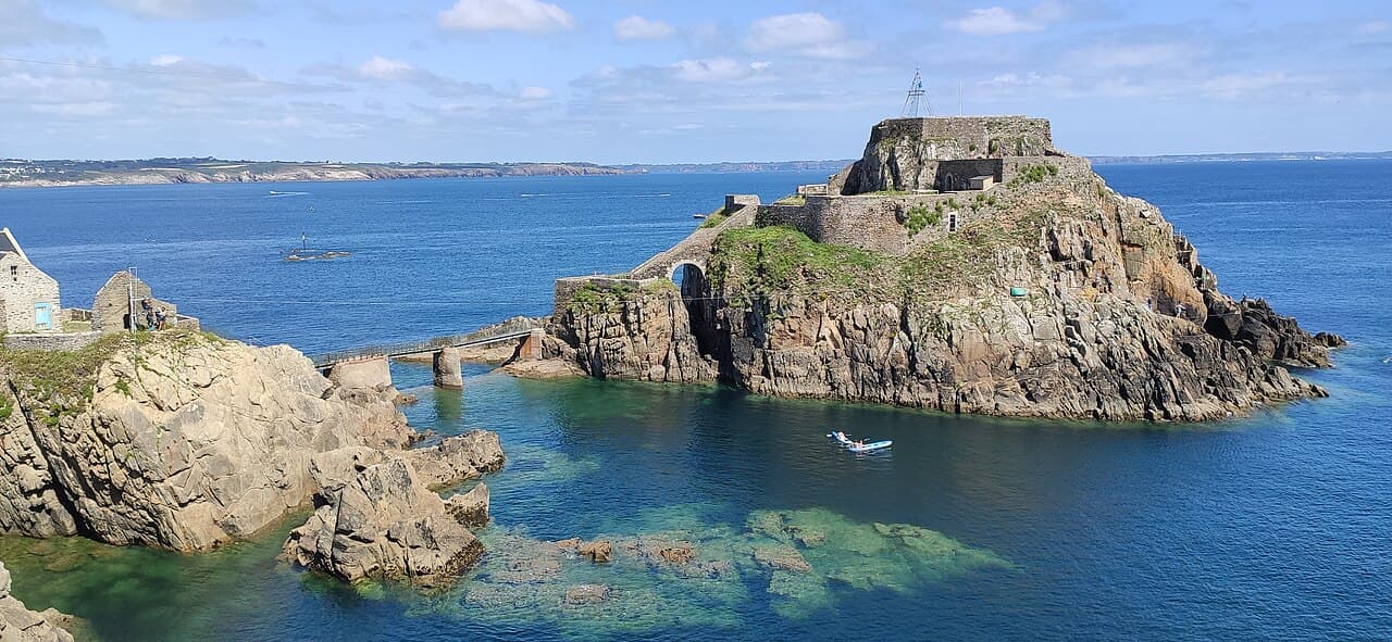
Fort de Bertheaume is a notable bastioned fortress situated on a small tidal island off the coast of Plougonvelin in the Finistère department of Brittany, France. Its strategic location at the entrance to the Goulet de Brest straits has made it a key defensive site for centuries. The fort's steep cliffs and rocky surroundings provide natural fortification, making it a difficult target for attackers.

Historical background and strategic importance

The site originally hosted a medieval fortification that was destroyed during an English attack in the 16th century. Recognizing the island's military value, the famed military engineer Sébastien Le Prestre de Vauban inspected the area in 1683 and proposed constructing a battery to strengthen Brest's coastal defenses. This led to the establishment of the current fort between 1694 and 1699, during the renaissance period, as part of a broader network of small forts and batteries designed to protect the vital naval harbour of Brest.

Architectural features and fortifications

The fort is built as a bastioned fortress with multiple levels of cannon batteries arranged on four tiers connected by steep stairs carved into the rock. The original fortifications occupy the larger island, while the smaller adjacent island features buildings dating from the 19th century. The walls of the fort still bear traces of chauguettes (watchtowers) bases and posterns that allowed access to the foot of the walls for defensive maneuvers.

Access to the island was historically limited to low tide crossings over a rocky bank or by a small boat pulled along a rope from the mainland at high tide, enhancing its defensibility. In the 20th century, a steel footbridge was constructed to connect the island permanently to the mainland.

Military use and later modifications

During its active military use, the fort served as a coastal defense point against naval threats, particularly from the English. By the late 19th century, it was abandoned in favor of a more modern casemated fort on the mainland. During World War II, the German forces constructed a small blockhouse on the island as part of their Atlantic Wall defenses.

Restoration and current status

In the 1990s, Fort de Bertheaume underwent restoration and was opened to the public as a cultural and historical site. Visitors can explore the fort's extensive underground powder magazine, carved 13 meters below ground into the rock, as well as exhibition rooms and a small restaurant housed in the 19th-century buildings on the smaller island.

The fort also offers a survival track experience, available during favorable weather conditions, adding an interactive dimension to the visit. It remains open year-round, providing insight into coastal defense architecture and military history in Brittany.

Geographical and cultural significance

Located within the cultural region of Brittany, Fort de Bertheaume is part of the extensive defense system guarding the entrance to the important naval harbour of Brest. Its position on a tidal island with naturally steep cliffs has made it a formidable defensive site throughout history, reflecting the evolution of coastal fortifications from the medieval period through the renaissance and into modern times.

Today, it stands as a preserved monument illustrating the military engineering advances of the late 17th century, the strategic foresight of Vauban, and the layered history of French coastal defense.

Frequently asked questions (FAQ)

What is the historical significance of Fort de Bertheaume?
Fort de Bertheaume is a 17th-century coastal fortification located in Plougonvelin, France. It was built to protect the entrance of the Brest harbor and played a strategic role during various military conflicts, including the Napoleonic Wars. Today, it stands as a testament to military architecture and history, attracting visitors interested in France's maritime past.
When is the best time to visit Fort de Bertheaume?
The best time to visit Fort de Bertheaume is during the spring and summer months, from April to September, when the weather is generally mild and pleasant. These months also feature longer daylight hours, allowing for ample time to explore the fort's grounds and enjoy the surrounding scenery. Additionally, special events and guided tours are often scheduled during this period.
Can I access Fort de Bertheaume with mobility challenges?
Yes, Fort de Bertheaume is accessible to visitors with mobility challenges. The site has made efforts to ensure that key areas are reachable for everyone, including ramps and designated pathways. However, some sections may still present challenges due to the fort's historical design, so it's advisable to check in advance for specific accessibility options.
What are the opening hours for Fort de Bertheaume?
Fort de Bertheaume is typically open to visitors from 10 AM to 6 PM during the peak season, with reduced hours in the off-peak months. It is recommended to check the official website for the most current information and any seasonal changes to the schedule. Guided tours may have specific time slots, so booking in advance is advisable.
How much do tickets cost for Fort de Bertheaume?
Tickets for Fort de Bertheaume are reasonably priced, with adult tickets typically around €6 and reduced rates for students and seniors. Children under a certain age may enter for free, making it an affordable option for families. Group discounts are also available, so consider visiting with friends or family to take advantage of these offers.
Is it possible to explore nearby attractions while visiting Fort de Bertheaume?
Absolutely! Fort de Bertheaume is located near several other attractions such as the beautiful beaches of Plougonvelin and the stunning Pointe Saint-Mathieu lighthouse. Visitors can combine their trip to the fort with a scenic walk along the coast or a visit to the nearby Abbey of Saint-Mathieu, enriching their experience in this picturesque region of Brittany.
What architectural features can I expect to see at Fort de Bertheaume?
Fort de Bertheaume showcases classic military architecture, including robust stone walls, bastions, and a strategically designed layout that maximizes defense capabilities. Visitors can appreciate the intricate craftsmanship of the 17th century, as well as the stunning views from the fort's elevated position overlooking the coast. Interactive exhibits within the fort provide additional context about its architectural significance.

Photo gallery

Fort de Bertheaume
Click to view

Photo by Thesupermat•CC BY-SA 4.0

1 photo • Click any image to view in full screen

Information

Bastioned Fortress

Loading map...

Visitor reviews

No reviews yet. Been here? Write the first review and help other travelers!

Write the first review

Visited this castle? Share your experience

Your review helps other travelers and adds first-hand knowledge to our encyclopedia.
Write a review

(5/5)

0/2000 characters

Your review will be visible after admin approval

Nearby castles

1.7 km

Fort of Bertheaume

Plougonvelin, France

Fort of Bertheaume is a remarkable historic fortress situated on a tidal island near Plougonvelin in the Finistère department of Brittany, France. This strategic location commands the Goulet de Brest, a vital maritime passage leading to the important naval port of Brest. The fort's position atop steep cliffs overlooking the sea has made it a naturally defensible site for centuries, playing a crucial role in the coastal defense of the region.The site of Fort of Bertheaume has a long history of human activity, dating back to the Mesolithic period, as evidenced by a distinctive flint workshop found nearby. Bronze Age chamber tombs on the adjacent mainland further attest to the area's prehistoric significance. Although Roman artifacts such as pottery shards and tile fragments from the 2nd and 3rd centuries CE have been uncovered, they suggest limited Roman presence, likely related to maritime activity rather than permanent settlement.During the early medieval era, the region saw the influence of Irish and Welsh monks, with Saint Sané associated with the nearby parish of Plouzané, reflecting early Christian evangelization. The fort's name remains somewhat mysterious, with the Breton name "Kastel Persel" and a possible derivation from Saint Bertram, a figure linked to the founding of Staddford.Medieval origins and early historyA castle was established on the site by the early 14th century, predating the Breton Succession War (1344-1364). Initially owned by the Viscount of Léon, it later passed to the Duke of Brittany. The strategic importance of the fort was underscored during the English occupation between 1366 and 1397, when it served as a military stronghold. It was during this period that the name "Bertheaume" came into use, likely derived from a saintly figure such as Saint Bertem or Bertellin.In 1558, the original castle was destroyed during an Anglo-Dutch raid that devastated the surrounding settlements and the nearby Abbey of Saint-Mathieu. This event marked a significant turning point, leading to the fort's reconstruction and modernization in subsequent centuries.Fortification and military evolution from the 17th centuryIn 1689, the celebrated military engineer Vauban constructed a battery on the island as part of the coastal defenses protecting Brest from English naval attacks. This battery was instrumental in repelling the 1694 Anglo-Dutch assault on Camaret-sur-Mer, demonstrating the fort's strategic value.From 1700, under the supervision of artillery officer Benoît de Musinot, the fort underwent significant expansion. This phase introduced a complex fortification system including a bastion, a semi-circular battery, a powder magazine located approximately 13 meters underground, barracks, and storage facilities. The 18th century saw the addition of a lower battery on the fort's east side, enhancing its defensive capabilities.The fort's defenses extended over two islands, with a smaller island near the mainland added in the 19th century. By 1793, the fort had fallen into disrepair but remained a key element in the coastal defense network.19th and 20th century military use and modern historyFollowing the Napoleonic Wars, the fort was disarmed. In 1835, a footbridge was constructed, replacing earlier access by boat or rope bridge and connecting the tidal island to the mainland permanently.Between 1880 and 1890, the fort's older structures were replaced with modern casemates on the mainland, housing heavy artillery designed to cover the Goulet de Brest. These included two 320mm guns, two 240mm guns, two 160mm guns, and smaller batteries equipped with 95mm quick-firing guns and 240mm mortars, reflecting advances in military technology and artillery range.During World War I, the fort played a surveillance role, firing a warning shot at a freighter in August 1914 and serving as a site for captive observation balloons monitoring German U-boat activity. However, its guns were soon redeployed to the front lines.In World War II, the fort was occupied and reinforced by German forces from 1940. Concrete blockhouses were constructed, and the fort was equipped with anti-aircraft guns, 75mm cannons, mortars, and machine guns. It resisted Allied advances until surrendering on 8 September 1944.Archaeological significance and preservation effortsAfter the war, the fort was abandoned by the French Ministry of Defence for approximately 45 years. In 1992, the commune of Plougonvelin acquired the site, initiating archaeological excavations and rehabilitation projects to preserve its rich historical legacy.Excavations have uncovered significant prehistoric artifacts, including Mesolithic flints distinctive enough to define a regional Mesolithic period named after the site. Bronze Age chamber tombs and limited Roman artifacts have also been found, highlighting the site's long-term human use.Rehabilitation efforts have included clearing vegetation, rebuilding the footbridge multiple times due to storm damage, and adapting the lower battery for cultural uses such as an exhibition space, open-air theatre, and restaurant. The landward section hosts an open-air theatre surrounded by menhir alignments installed in the 1990s, blending historical preservation with contemporary cultural activities.Architectural features and layoutThe fort's layout is notable for its multi-level batteries arranged on four terraces connected by stairs. Posterns provide access to the base of the walls, facilitating movement and defense. The main construction phase under Benoît de Musinot introduced a bastion and a semi-circular battery, with a powder magazine deeply embedded underground for protection.The smaller 19th-century island adjacent to the main tidal island contains additional batteries, reflecting the evolving military needs of the 19th century. The modern casemates on the mainland represent a significant shift in coastal defense architecture, designed to house heavy artillery and withstand modern warfare.During the German occupation, the addition of concrete blockhouses and anti-aircraft emplacements further modified the fort's defensive profile, integrating 20th-century military technology into the historic site.Cultural and strategic importanceThroughout its history, Fort of Bertheaume has served as a critical defensive point guarding the approaches to Brest, one of France's most important naval ports. Its commanding position over the Goulet de Brest has made it a focal point in regional military strategy from the medieval period through modern times.The fort also functioned historically as an anchorage for vessels awaiting favorable winds to enter Brest harbor, linking its military role with maritime navigation. It functioned as the northern counterpart to the defenses at Camaret-sur-Mer, together forming a defensive network protecting the Breton coast.Today, the fort stands as a testament to centuries of military architecture and coastal defense evolution, attracting visitors interested in history, archaeology, and military heritage. Its preservation and adaptive reuse for cultural events ensure that this historic fortress continues to play a vibrant role in the local community.

Late Medieval (14th–15th c.)
Details
13.8 km

Château de Keroual

Guilers, France

Château de Keroual is a notable example of a Renaissance manor castle located in Guilers, France. Constructed in the 16th century, this castle reflects the architectural transition from medieval fortifications to more residential and elegant noble estates typical of the Renaissance period. It originally served as a manor house for local nobility, combining defensive elements with more comfortable living quarters. Architectural features and style The castle was built in the Renaissance style, characterized by symmetrical layouts, classical proportions, and decorative elements inspired by ancient Roman and Greek architecture. While the castle retains some defensive features, such as thick stone walls and possibly a moat or courtyard enclosure, its primary function was residential rather than military. The manor likely included large windows to allow natural light, ornate fireplaces, and decorative stonework around doors and windows, typical of Renaissance aesthetics. Layout and construction The château's plan probably consisted of a central residential block with attached wings forming a courtyard. The use of local stone and traditional masonry techniques would have been prevalent. The interiors, now largely lost or damaged, would have featured wood paneling, plaster ceilings, and carved stone details reflecting the tastes of the period. Historical context and significance Built during the Renaissance period, Château de Keroual exemplifies the shift in French noble residences from purely defensive castles to more comfortable and stylistically refined manors. This transition coincided with the relative internal peace in France, allowing aristocrats to focus on comfort and display of status. The castle's location in Brittany placed it within a region rich in medieval and Renaissance heritage, where many noble families built similar manors. It served as a local seat of power and a symbol of noble prestige in the area. Damage and current condition During the German occupation of France in World War II, Château de Keroual was partially destroyed by fire in 1944. This event severely damaged the structure, leaving it in a partially ruined state. Since then, the castle has not been fully restored, and much of its original interior and architectural details have been lost. Despite its ruined condition, the castle remains an important cultural and historical landmark in Guilers. The surviving walls and architectural fragments offer valuable insight into Renaissance manor construction and noble life in 16th-century Brittany. Preservation and cultural importance Efforts to preserve the remains of Château de Keroual focus on stabilizing the ruins and preventing further decay. The site attracts visitors interested in French Renaissance architecture and the history of Brittany's noble estates. It also serves as a poignant reminder of the destruction wrought by war on cultural heritage. Visitor information While the castle is not fully restored and access may be limited, visitors can appreciate the exterior ruins and the historical context of the site. The castle's location in Guilers makes it accessible for those exploring the rich heritage of Brittany.

Renaissance (15th–17th c.)
Details
14 km
Questel Fort — France castle

Questel Fort

Brest, France

Questel Fort (French: Fort du Questel; Breton: Kreñvlec'h Questel) is a prominent example of an 18th-century bastioned fortress located in the city of Brest, France. Constructed during the post-Renaissance period, it represents the military architectural principles of the renowned French military engineer Sébastien Le Prestre de Vauban, whose designs revolutionized fortifications in the late 17th and early 18th centuries. Questel Fort is a fortified redoubt designed to protect the strategic approaches to Brest, particularly overseeing the valleys of the Moulin du Buis and the Allégoet valley, a tributary of the Penfeld river, preventing enemy forces from establishing positions that could threaten the city and its vital harbor. Architectural design and layout The fort forms a closed quadrangle approximately 100 meters wide, constructed with robust masonry walls known as scarps. These walls are surrounded by deep moats and accessed via a drawbridge, typical of Vauban's defensive schemes. The walls are topped with a chemin de ronde, a covered walkway for musketeers to patrol and defend the perimeter. Above this walkway lies an earthen rampart designed with angled bastions to support artillery placements, with a total of 26 guns positioned to cover all approaches. The fort's layout emphasizes defense in depth, with scarps and counterscarps forming layered defensive walls. The interior includes a central courtyard connected to the parapets by two large underground galleries, allowing safe and concealed movement of the garrison during combat. These galleries also provide access to essential facilities, including toilet facilities—a notable feature at the time reflecting advanced considerations for the garrison's welfare. Strategic importance and historical context Questel Fort was part of a broader network of fortifications designed to protect Brest, a critical naval base on the Atlantic coast of France. It lies between Fort Keranroux to the south and Fort Penfeld to the northeast, forming a defensive chain that includes Fort Montbarey. This strategic positioning allowed coordinated defense against land assaults and naval threats during periods of conflict, particularly in the 18th century when European powers vied for maritime dominance. The fort's construction reflects the military engineering advances of the post-Renaissance era, adapting to the increasing use of artillery in warfare. Its bastioned design allowed defenders to cover all approaches with overlapping fields of fire, minimizing blind spots and enhancing the fortress's resilience against sieges. Garrison and daily life The fort was garrisoned by approximately 200 soldiers, who lived and worked within its walls. The underground galleries and protected walkways allowed the garrison to move safely and efficiently, even under attack. The presence of sanitary facilities within the fort was advanced for its time, indicating a concern for hygiene and the health of the soldiers, which was uncommon in many contemporary military installations. The spacious central courtyard served as a hub for daily activities, drills, and mustering troops. The fort's design balanced defensive needs with the practical requirements of sustaining a military presence in a potentially hostile environment. Current condition and visitor experience Today, Questel Fort is well preserved and forms part of a series of refurbished natural spaces around Brest. Visitors can explore its sheltered green moat, underground galleries, staircases, scarps and counterscarps, and the esplanade that offers views of the surrounding valleys. The site connects to walking trails leading to the banks of the Penfeld river, passing near the Cavale Blanche hospital. The fort is an important cultural and historical landmark, illustrating the evolution of military architecture and the strategic defense of Brest. Its accessible pathways and preserved structures provide insight into 18th-century fortress life and Vauban's enduring influence on fortification design. Architectural features in detail Moats and drawbridge The fort is surrounded by deep moats that serve as a formidable obstacle to attackers. The drawbridge is positioned on the least exposed side, providing controlled access while maintaining the fort's defensive integrity. Chemin de ronde and ramparts The chemin de ronde allows musketeers to patrol the walls under cover, while the earthen ramparts are angled to maximize the effectiveness of the artillery emplacements. These features embody Vauban's principles of combining natural and constructed defenses. Underground galleries The two large underground galleries connect the central courtyard to the parapets, enabling protected movement for the garrison and storage of ammunition and supplies. These galleries are a hallmark of Vauban-style fortifications, enhancing the fort's resilience during sieges.

Post-Renaissance (17th–18th c.)
Details