Cin Tower

Cin Tower in Payas, Turkey
Payas, Hatay, Turkey
Renaissance (15th–17th c.)
Restored

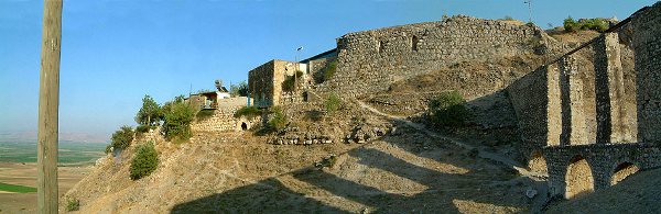
Cin Tower, locally known as Cin Kule or Cin Kulesi, stands as a notable example of Ottoman military architecture in the town of Payas, located in the Hatay province of Turkey. Constructed in the 16th century during the Renaissance period, this tower was part of a strategic initiative by the Ottoman Empire to secure and develop the coastal region along the Gulf of Alexandretta.

The historical significance of Payas as a port town emerged prominently in the latter half of the 16th century when the Ottomans established it as a complementary harbor to the nearby port of Ayas. This development was closely linked to the patronage of Grand Vizier Sokollu Mehmed Pasha, a key figure in Ottoman administration and military affairs. Under his direction, two main fortifications were erected: the Cin Tower, which served as a harbor guard, and the larger Payas Castle, situated approximately 700 meters inland. The castle protected a complex known as a bedesten, which included a mosque, a bazaar, and a madrasa, highlighting the integration of military and commercial functions in the area.

Architectural features and strategic role

Cin Tower was designed primarily as a coastal defense structure. Its location near the harbor allowed it to oversee maritime traffic and protect the port from potential naval threats. The tower's architecture reflects typical Ottoman military design of the period, with robust stone walls intended to withstand attacks and provide a vantage point for surveillance.

The tower's construction utilized local stone materials, and its design emphasized both functionality and durability. Although smaller than the inland Payas Castle, Cin Tower played a crucial role in the defense network of the region, working in tandem with the castle to secure the port and surrounding settlements.

Historical context and developments

During the 16th century, the Ottoman Empire was consolidating its control over the eastern Mediterranean, and fortifications like Cin Tower were essential elements of this strategy. Payas' position on the Gulf of Alexandretta made it a valuable asset for controlling maritime routes and facilitating trade.

Payas flourished as a trading center well into the 19th century. However, the area suffered significant damage during military conflicts involving the troops of Kücük Ali, which led to the decline of the fortifications' condition. The damage inflicted during these conflicts marked the beginning of a period of neglect for the tower and the surrounding structures.

Restoration and modern use

In the early 21st century, efforts were made to restore the ruined Cin Tower. The restoration aimed to preserve the tower's historical and architectural integrity while adapting it for contemporary use. Following restoration, the tower was repurposed as a restaurant, which operated until at least 2019, allowing visitors to experience the historic site in a new context.

Today, Cin Tower is freely accessible to the public. It is situated adjacent to a small public park, providing a pleasant setting for visitors to explore the tower and appreciate its historical significance. Despite its restoration and adaptive reuse, the tower currently appears somewhat neglected, reflecting challenges in maintaining heritage sites over time.

Visiting Cin Tower

Visitors to Cin Tower can enjoy its coastal location and the views of the harbor it once guarded. The tower's proximity to the town center of Payas makes it an accessible destination for those interested in Ottoman military architecture and regional history.

The site offers insights into the strategic maritime defenses of the Ottoman Empire and the development of port towns in southern Turkey. While the tower itself is relatively modest in size, its historical context and connection to the larger Payas Castle complex enrich the visitor experience.

Frequently asked questions (FAQ)

What is the historical significance of Cin Tower?
Cin Tower was built in the 16th century by the Ottomans to guard the harbor of Payas, serving as a strategic coastal defense point during the Renaissance period.
Can I visit Cin Tower today?
Yes, Cin Tower is currently open to the public and can be visited freely. It is located near a small public park in Payas, providing easy access for visitors interested in Ottoman architecture.
When was Cin Tower restored?
The tower was restored in the early 21st century after falling into ruin, and it was repurposed as a restaurant until at least 2019.
What architectural style does Cin Tower represent?
Cin Tower reflects typical Ottoman military architecture of the 16th century, designed for coastal defense with robust stone construction.
How far is Cin Tower from Payas Castle?
Cin Tower is approximately 700 meters from Payas Castle, both built under the patronage of Grand Vizier Sokollu Mehmed Pasha to protect the harbor and town.

Information

Water Castle

Address

İnönü Cd., Payas, Hatay, Turkey

Loading map...

Visitor reviews

No reviews yet. Been here? Write the first review and help other travelers!

Write the first review

Visited this castle? Share your experience

Your review helps other travelers and adds first-hand knowledge to our encyclopedia.
Write a review

(5/5)

0/2000 characters

Your review will be visible after admin approval

Nearby castles

0.7 km

Payas Castle

Payas, Turkey

Payas Castle, locally known as Payas Kalesi, is a significant 16th-century Ottoman fortress located in the town of Payas, within the province of Hatay, Turkey. This castle played a crucial role in the Ottoman Empire's coastal defense and trade network during the Renaissance period, serving as a complementary port to the nearby Ayas across the Gulf of Alexandretta. Historical context and Ottoman foundation There is limited information regarding any pre-Ottoman settlement at Payas, but the existing fortifications date back to the second half of the 16th century. The Ottomans strategically settled Payas to bolster maritime control and commerce along the eastern Mediterranean coast. Under the patronage of the influential Grand Vizier Sokollu Mehmed Pasha, two key fortifications were constructed: the Cin Tower, which guarded the harbor, and the larger Payas Castle, positioned slightly inland to protect a vital commercial and religious complex known as a bedesten. This complex included a mosque, a bazaar, and a madrasa, reflecting the Ottoman emphasis on integrating military, commercial, and social functions within fortified sites. Architectural features and layout Payas Castle is designed with a roughly pentagonal plan, featuring a single circuit wall that encloses the interior. The defensive perimeter includes seven towers and a prominent gate tower. Surrounding the castle is a deep dry moat with vertical sides faced with masonry, enhancing the fortress's defense against siege tactics. The castle has a single entrance located on the east wall, which is fortified by a barbican – a fortified outpost or gateway designed to protect the main gate from direct assault. The bedesten and its significance The bedesten adjacent to the castle was a central hub for trade and social interaction. It housed a covered market where merchants could sell goods securely, supported by the nearby mosque and madrasa which served the spiritual and educational needs of the community. This integration of commerce, religion, and education within the fortified area highlights the multifaceted role of Ottoman castles beyond mere military functions. Historical events and later developments Payas remained an active and thriving trading center well into the 19th century. However, the site suffered considerable damage during military conflicts, notably inflicted by the troops of Kücük Ali in the mid-1800s. Despite this, the castle and its associated structures have survived, preserving much of their original character. Modern restoration and visitor experience In recent years, Payas Castle and the bedesten have undergone restoration efforts aimed at preserving their historical and architectural integrity. The bedesten has been fully restored and is now operational, welcoming visitors who can explore the market area and appreciate its historical ambiance. Unfortunately, the interior of the castle itself remains closed to the public, limiting access to its internal spaces. Nevertheless, the castle's exterior, combined with the nearby Cin Tower and the bedesten, offers a compelling visit for those interested in Ottoman military architecture and urban history. Architectural style and classification The castle exemplifies Renaissance Ottoman military architecture, characterized by robust fortifications adapted to the evolving artillery technology of the period. Its pentagonal layout and dry moat are typical defensive features designed to withstand sieges and cannon fire. The castle is classified as a lowland castle, given its position near the coast and the harbor facilities it was intended to protect. Location and strategic importance Situated in the town of Payas on Deniz Street, the castle occupies a strategic position overlooking the Gulf of Alexandretta. This location allowed the Ottomans to control maritime traffic and secure a vital commercial route between the Mediterranean and the interior of Anatolia. The proximity of the castle to the harbor and the bedesten complex underscores its role as both a military stronghold and a commercial center. Visitor information and accessibility Visitors to Payas can freely explore the restored bedesten and admire the castle's exterior fortifications. While the castle interior is currently closed, the surrounding area offers a rich historical experience. The nearby Cin Tower, only about 700 meters away, complements the visit by providing insight into the harbor defenses. The site is accessible from the town center, making it a convenient destination for those interested in Ottoman history and architecture.

Renaissance (15th–17th c.)
Details
11.3 km

Sarıseki Castle

East of the D817-road, Turkey

Sarıseki Castle, locally known as Sarıseki Kalesi, is a historic fortress situated on a rocky hill just south of the village of Sarıseki, in the Hatay province of Turkey. This castle occupies a strategic position near the southern end of the Nur Mountains, historically called the Amanus Mountains, overlooking a narrow passage known as The Portella. The castle's proximity to the sea—only about one kilometer away—allowed it to control access between the coast and the fertile Cilician plain, making it a key military and trade point throughout its history. Origins and early history The earliest fortifications at Sarıseki Castle likely date back to Antiquity, although the present structure is primarily attributed to the Knights Templar. The Templars constructed the castle in the 12th century as part of their efforts to secure the southern approaches of the Nur Mountains and protect the crucial mountain pass that connected the Mediterranean coast to the Cilician plain. This location was vital for controlling movement and trade routes in the region. The Portella and the Pillar of Jonah The Portella was the narrow passageway between the castle's hill and the seafront, serving as the southern gateway to the Cilician plain. On a rocky outcrop between the passage and the sea, there once stood a tower, which likely functioned as a toll station or watchtower. This tower may have been linked to Sarıseki Castle by a defensive wall, although only a small fragment of this structure remains today. This fragment is locally known as the Pillar of Jonah (Yunus Sütunu in Turkish). According to religious tradition, it marks the spot where the prophet Jonah was released after being swallowed by a whale. However, historical and archaeological evidence suggests it is more likely a remnant of a Roman triumphal arch, indicating the site's long-standing significance predating the Crusader period. Medieval control and military significance Between 1135 and 1150, Sarıseki Castle was probably occupied by the Armenian Prince Thoros II and may have been held twice by the Byzantines. Around 1154, control of the castle and surrounding forts passed to Reginald of Antioch, who returned them to the Knights Templar. The Templars maintained continuous control of Sarıseki until 1266, when the castle fell to the Mamluk Sultan Baibars after a siege. Baibars' forces captured the fortress and massacred its occupants, marking a significant shift in regional power. Strategic role in the Crusader states Sarıseki Castle formed part of a network of fortifications guarding the southern approaches to the Crusader-held territories in Cilicia. Its position allowed the Templars to monitor and control movement along the coastal routes and mountain passes, serving both military and economic purposes. The castle's defensive capabilities and its control over the Portella passage made it a valuable asset during the turbulent conflicts of the 12th and 13th centuries. Ottoman reconstruction and later history The present ruins of Sarıseki Castle largely reflect the Ottoman reconstruction efforts in the 16th century. Following the Crusader period, the castle fell into disrepair until it was rebuilt according to the original Crusader plan. An inscription above the entrance door records that the Ottoman Sultan Suleiman the Magnificent ordered the reconstruction on March 3, 1546. This rebuilding reinforced the castle's defensive role in the Ottoman frontier region, adapting medieval fortifications to contemporary military needs. Architectural features and layout The castle is built on a rocky hilltop, utilizing the natural terrain for defense. The original Crusader design included thick curtain walls, towers, and a gatehouse controlling access to the inner courtyard. The Ottomans preserved much of this layout during their reconstruction, maintaining the castle's strategic vantage points over the surrounding landscape and the sea. Although much of the structure is now in ruins, key elements such as sections of the walls and the entrance gate remain visible. The castle's interior is heavily overgrown, which, while obscuring some features, contributes to a sense of discovery for visitors exploring the site. Present condition and visitor experience Sarıseki Castle stands today as a partially preserved ruin within the grounds of an abandoned military complex. The site is freely accessible, though it is somewhat hidden behind trees and dense vegetation. Visitors can explore the remains of the castle, including the walls and the entrance, although the overgrowth limits visibility of some features. The castle's location and historical layers—from Roman times through the Crusader period to the Ottoman era—make it an intriguing destination for those interested in military architecture and medieval history. Its remote and somewhat neglected state adds to its atmosphere as a hidden gem in the Hatay region. Access and surrounding area Sarıseki Castle is located east of the D817 road, near the Mediterranean coast. The surrounding region offers a rich historical context, with numerous other Crusader and medieval sites in Hatay province. Visitors to Sarıseki can combine their visit with explorations of nearby ancient ruins and natural landscapes.

High Medieval (11th–13th c.)
Details
29.3 km
Trapesac Castle — Turkey castle

Trapesac Castle

Hz. Beyazıt Bestami Yolu, Turkey

Trapesac Castle, also known locally as Darbsak or Terbezek Kalesi, is a medieval fortress situated on a small oblong limestone outcrop in the village of Alaybeyli, within the province of Hatay, Turkey. This castle occupies a commanding position overlooking the strategic road leading to Antioch and the northern approach to the Belen Pass, also known historically as the Syrian Gates, which cuts through the Nur Mountains. Its location made it a vital military stronghold controlling access between the coastal region of Cilicia and inland Syria. The origins of Trapesac Castle trace back to the 11th century, when it was constructed by the Franks as a garrison fortification. The castle was later ceded to the Knights Templar, a military order renowned for their role in the Crusades. Alongside Baghras Castle, located about 15 kilometers to the south guarding the southern approach to the Belen Pass, Trapesac formed part of a defensive network securing this crucial mountain pass. Architectural features and layout Trapesac Castle's architecture reflects its military function and the rugged terrain on which it was built. The castle occupies a narrow limestone ridge, which dictated a linear layout adapted to the natural topography. Although much of the original structure has been obscured or destroyed, remnants of the castle walls, towers, and defensive structures can still be discerned. A notable feature is a Crusader-era aqueduct on the west side of the outcrop, which supplied water to the fortress, an essential element for sustaining a garrison during sieges. The castle's fortifications would have included curtain walls, battlements, and likely a keep or donjon, typical of Frankish military architecture of the period. The steep cliffs on several sides provided natural defense, reducing the need for extensive artificial fortifications on those faces. However, the approach from the east was modified in modern times by the construction of a terraced dead-end road, which has altered the original defensive landscape. Historical significance and military history Early control and crusader period Trapesac Castle was a key military asset during the High Medieval period, particularly during the Crusades. After its initial construction by the Franks, it was handed over to the Knights Templar, who maintained control due to its strategic importance. The castle's primary role was to guard the northern entrance to the Belen Pass, a vital route for armies and trade between Cilicia and Syria. Conflicts and sieges In the late 12th century, the castle was the focus of numerous military confrontations. Around 1171, the fortress was seized by Mleh, a renegade Armenian baron, who also took control of Baghras Castle. Following Mleh's death in 1175, the Templars regained Trapesac. However, in 1188, the castle fell to Saladin, the Ayyubid Sultan, after a fierce siege lasting approximately two weeks. The castle continued to be contested in the early 13th century. In 1205, Leo I, King of Cilician Armenia, attempted to capture the fortress from the prince of Aleppo but was unsuccessful. Again, in 1237, the Crusaders launched an expedition to retake the castle but suffered a significant defeat at the hands of the Saracen garrison. Later medieval period and changing hands From 1261, Hetoum I of Cilician Armenia controlled Trapesac after it was granted to the Armenians by the Mongol Khan Hulagu. However, the Armenians' hold was short-lived. Following the defeat of the Armenian army at the Battle of Mari in 1266, Hetoum surrendered the castle to the Mamluks to ransom his son, Leo. The fortress then passed into the hands of the Egyptian Mamluk Sultan Baybars in 1268. In 1280, the castle briefly returned to Mongol control under Abaqa Khan during his campaign in Syria, but was abandoned when the Mongols withdrew. The castle suffered considerable damage during these conflicts, particularly from Mongol assaults. Current condition and archaeological remains Today, much of the original castle grounds have been overtaken by the modern village of Alaybeyli, which has obscured the fortress's full extent. A modern road has been cut into the eastern face of the limestone outcrop, further altering the site's historic topography. Despite these changes, some ruins remain visible, including portions of the defensive walls and the Crusader aqueduct. The castle is classified as a hill castle due to its elevated position on a natural limestone outcrop. Its current condition can be described as ruins, with only fragments of the original structure surviving. The site offers valuable insights into the military architecture of the Crusader period and the complex history of control between Crusaders, Armenians, Mongols, and Mamluks in the region. The strategic importance of trapesac castle Trapesac Castle's location on the northern approach to the Belen Pass made it a linchpin in controlling movement through the Amanus Mountains. This pass was the main gateway between the Mediterranean coast and the inland plains of Syria, making the castle a focal point for military campaigns and trade routes. Its control was vital for the Principality of Antioch, the Armenian Kingdom of Cilicia, and later the Mamluk Sultanate. The castle's repeated change of hands reflects the shifting political and military landscape of the region during the High Medieval period, particularly during the Crusades and the Mongol invasions. Architectural influences and military engineering The castle's design demonstrates typical features of Frankish military architecture adapted to the rugged terrain. The use of natural rock formations for defense, combined with constructed walls and towers, exemplifies medieval military engineering aimed at maximizing defensive capabilities while minimizing construction effort. The presence of the Crusader aqueduct is particularly notable, as water supply was crucial for sustaining the garrison during prolonged sieges. Such infrastructure highlights the strategic planning involved in fortress design during this era. Visiting trapesac castle today Visitors to Trapesac Castle will find limited visible remains due to the encroachment of the modern village and alterations to the site. However, the castle's historical significance and its commanding location continue to attract interest from historians, archaeologists, and enthusiasts of medieval military architecture. The site offers a tangible connection to the complex history of the Crusades, Armenian Cilicia, and the Mongol and Mamluk conflicts that shaped the region. While facilities and interpretive materials may be limited, the castle's ruins and surrounding landscape provide a powerful sense of the strategic importance this fortress once held.

High Medieval (11th–13th c.)
Details