Castle of Castelo Melhor

Castle of Castelo Melhor: medieval fortress in Guarda, Portugal
Castelo Melhor, Portugal
High Medieval (11th–13th c.)

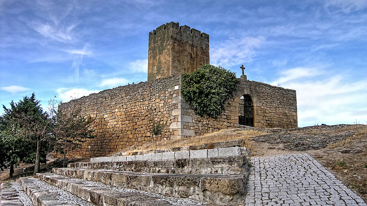
The Castle of Castelo Melhor stands as a remarkable example of a secondary medieval fortress strategically positioned in the peripheral zones of the Iberian Peninsula's historic kingdom. Nestled in the rural region of Guarda, Portugal, this fortress commands a significant vantage point, situated approximately 450 metres above sea level on a hilltop overlooking the right bank of the Coa River. Its location not only provided defensive advantages but also allowed control over the surrounding territory and river access routes, which were crucial during the High Medieval period.

The castle's courtyard is ingeniously integrated into the natural rocky terrain, incorporating large boulders into its foundation and walls. This adaptation to the landscape is a typical feature of hill castles, where builders utilized the natural topography to enhance fortification strength and reduce construction efforts. The castle's overall layout follows an irregular polygonal plan that conforms to the contours of the hilltop, maximizing defensive coverage and minimizing blind spots.

Architectural features and fortifications

The castle walls are constructed primarily from small schist stones, a locally available material, which contributes to the fortress's integration with its natural surroundings. The walls vary in height from approximately 3 to 6 metres and notably lack merlons, the upright sections of battlements typically used for cover by defenders. Despite this, the walls include an access staircase to the battlements, indicating that the defensive walkways were functional for surveillance and defense.

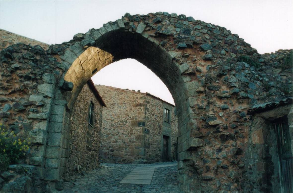
One of the most distinctive features of the castle is its triple arch gate located on the northwest side, which would have served as the main entrance. This gate design not only provided a controlled access point but also enhanced the castle's defensive capabilities by creating a choke point for any attacking forces.

Adjoined to the northern wall is a circular tower, a common medieval fortification element that served as a lookout and stronghold within the castle's defenses. Circular towers were preferred over square ones in later medieval fortifications because their shape better deflected projectiles and eliminated weak corners.

Between the gate and the circular tower lie the vestiges of a reinforcement wall, which, along with a similar structure along the southern wall, suggests the former existence of a barbican. Barbicans were fortified outworks placed in front of the main gate to provide additional defense and delay attackers, underscoring the strategic military importance of the castle.

Historical context and significance

Constructed in the 11th century, the Castle of Castelo Melhor was built during a period of intense territorial conflicts and consolidation in the Iberian Peninsula. This era corresponds to the High Medieval period, characterized by the expansion of Christian kingdoms during the Reconquista and the establishment of defensive strongholds to secure borders and control key routes.

As a hill castle, Castelo Melhor played a critical role in regional defense, overseeing the Coa River valley, which was an important corridor for movement and trade. Its position allowed monitoring of both military and economic activity, contributing to the stability and security of the surrounding settlements.

The castle's design reflects typical medieval military architecture adapted to the local environment, emphasizing functionality and strategic advantage over ornamental features. Its preservation, though partial and with some damage to the walls, offers valuable insights into medieval fortification techniques and the socio-political landscape of the region during the Middle Ages.

Current condition and preservation

Today, the Castle of Castelo Melhor remains a partially preserved monument. The walls, although damaged and missing merlons, still stand to heights of up to 6 metres in places, and the main architectural features such as the triple arch gate and circular tower are identifiable. The remnants of the barbican structures provide additional context to the castle's defensive layout.

The castle is accessible to visitors interested in medieval architecture and history, offering panoramic views of the Coa River valley and the surrounding landscape. Its integration into the rocky hilltop and use of local materials contribute to its authenticity and historical ambiance.

Architectural style and classification

The Castle of Castelo Melhor is classified as a hill castle due to its elevated position and use of natural terrain for defense. Architecturally, it embodies characteristics of High Medieval military construction with a focus on practical fortification features rather than elaborate stylistic elements. The use of schist stone and the polygonal wall layout are indicative of regional building practices adapted to the rugged landscape.

Frequently asked questions (FAQ)

How do I get to the Castle of Castelo Melhor?
The Castle of Castelo Melhor is located in the village of Castelo Melhor, Portugal, easily accessible by car. There are also public transport options available, including buses that connect to nearby towns. Parking is available near the castle for visitors.
What is the historical significance of the Castle of Castelo Melhor?
The Castle of Castelo Melhor dates back to the 12th century and played a crucial role in the defensive strategy during the Reconquista. It served as a stronghold for the Christian forces reclaiming territory from the Moors. Today, it stands as a testament to Portugal's rich medieval history.
When was the Castle of Castelo Melhor built?
Construction of the Castle of Castelo Melhor began in the 12th century, around the time of the Reconquista. It was strategically built to oversee and protect the surrounding lands. The castle has undergone various renovations over the centuries, preserving its historical architecture.
Can I visit the Castle of Castelo Melhor year-round?
Yes, the Castle of Castelo Melhor is open to visitors throughout the year. However, it is recommended to check the local weather and any seasonal events that might affect accessibility. Guided tours are often available to enhance your visit.
Why is the architecture of the Castle of Castelo Melhor unique?
The architecture of the Castle of Castelo Melhor reflects a blend of Romanesque and Gothic styles, showcasing its historical evolution. Its imposing walls and strategic layout are designed for defense, while the views it offers are breathtaking. The castle’s preservation allows visitors to appreciate its historical significance and architectural beauty.
Is it possible to access the Castle of Castelo Melhor for people with disabilities?
The Castle of Castelo Melhor has made efforts to improve accessibility for all visitors. However, due to its historical structure, some areas may be challenging for those with mobility impairments. It is recommended to contact the site in advance to inquire about specific accessibility features.
What are the opening hours for the Castle of Castelo Melhor?
The Castle of Castelo Melhor typically opens at 9 AM and closes at sunset, with hours varying by season. During peak tourist seasons, the castle may extend its hours to accommodate more visitors. It is advisable to check the official website for the most current information before your visit.
Are there any nearby attractions to visit while at the Castle of Castelo Melhor?
Yes, the surrounding area offers several attractions, including beautiful hiking trails and picturesque villages. Nearby, visitors can explore the historical town of Almeida, known for its fortifications. Local wineries and traditional Portuguese restaurants also provide a delightful experience for tourists.
What are the ticket prices for the Castle of Castelo Melhor?
Ticket prices for the Castle of Castelo Melhor are generally affordable, with discounts available for children and seniors. Admission fees help support the preservation of the castle and its grounds. It is advisable to check the official website for the latest information on ticket prices and any special offers.

Information

Sources & official resources

Verify the information above using these authoritative references.

Loading map...

Visitor reviews

No reviews yet. Been here? Write the first review and help other travelers!

Write the first review

Visited this castle? Share your experience

Your review helps other travelers and adds first-hand knowledge to our encyclopedia.
Write a review

(5/5)

0/2000 characters

Your review will be visible after admin approval

Nearby castles

0.4 km

Castelo Melhor

Portugal, Portugal

Castelo Melhor is a historic hilltop castle located in northern Portugal, overlooking the right bank of the Côa River. Its strategic position on a rocky hilltop about 450 meters above sea level has made it a significant defensive site from ancient times through the medieval period. The site was first fortified by the Turduli peoples in pre-Roman times, who established a castro, an early fortified settlement typical of the Iberian Peninsula. This early occupation laid the groundwork for the castle's enduring military importance. During the 12th century, the territory was under the control of the Kingdom of León. Between 1209 and 1210, King Alfonso VII of León granted a foral, or charter, to the settlement and ordered the construction of a castle to strengthen the military presence in this border region. The castle's initial purpose was to secure the area amid ongoing disputes between Portugal and Castile. Medieval fortifications and royal influence After the Treaty of Alcañices in 1297, Castelo Melhor was incorporated into the Kingdom of Portugal. King Dinis confirmed the settlement's privileges in 1298 and initiated significant modifications to the castle's defenses. These improvements included the addition of two rectangular towers flanking the main entrance on the northwest side, as well as a circular keep tower oriented toward the settlement to guard the only accessible approach. These fortifications reflect Castelo Melhor's role as a secondary defensive position within the Riba-Côa line, a frontier defense system. In the late 14th century, King Fernando ordered repairs to the castle. During the 1383–1385 dynastic crisis, Castelo Melhor briefly fell under Castilian control but was returned to Portugal by the Treaty of Monção in 1389. Early 15th-century repairs were undertaken under the reigns of King John I and King Afonso V. In 1422, the population of Castelo Melhor was recorded at approximately 1,704 inhabitants, and Afonso V elevated the settlement to town status, integrating it with the municipality of Almendra. Decline and noble ownership By 1496, the population had sharply declined to 204 residents. At the end of the 15th century, King John II granted the lands to João Fernandes Cabral. The castle and settlement became linked to noble families who later focused their power in Belmonte, which contributed to Castelo Melhor's decline in prominence. In 1584, the settlement was raised to the status of a county seat under Rui Mendes de Vasconcelos. During the 1640 Restoration Wars, an artillery battery was constructed on the eastern flank of the hilltop to enhance the castle's defenses. By the 18th century, Castelo Melhor was subordinate to Almendra, with the Counts of Castelo Melhor serving as donataries, or land grantees. In 1758, the settlement had 89 residents and was recognized as a defensible county seat, although it lacked a permanent garrison. The town was elevated to a marquisate in 1766. In 1855, the municipality of Almendra e Castelo Melhor was dissolved, and the area became part of Vila Nova de Foz Côa. Since 1982, Castelo Melhor has been classified as an Imóvel de Interesse Público (Property of Public Interest), reflecting its cultural and historical significance. Architectural features and remains The castle's layout is an irregular polygon shaped by the rocky terrain and large boulders on the hilltop. The defensive walls are constructed from small schist stones and vary in height between three and six meters. Unlike many medieval castles, the walls lack merlons, the upright sections typically found on battlements, but include a staircase that provides access to the wall walk. The main entrance on the northwest side is notable for its triple-arched gate, flanked by two rectangular towers added during King Dinis's early 14th-century reforms. Behind the northern wall stands a circular tower oriented toward the settlement, designed to protect the only accessible side of the castle. Between the gate and the circular tower, as well as along the southern wall, remains of reinforcement walls suggest the former presence of a barbican, a fortified outwork protecting the entrance. Additionally, three conical corbels are found behind the eastern and northwestern sections of the walls, serving as projecting supports for defensive structures. Within the castle courtyard lies a circular cistern without a cover, located in the northeast corner, which would have been essential for water storage during sieges. Nearby are the remains of several rectangular buildings, indicating the presence of internal structures such as living quarters or storage facilities. Today, the castle walls are generally in a damaged state, reflecting centuries of exposure and lack of permanent maintenance. Although it no longer houses a garrison, Castelo Melhor was historically considered defensible when necessary, particularly during periods of conflict along the Portuguese-Castilian border. Historical context and strategic importance Castelo Melhor's location overlooking the confluence of the Côa and Douro rivers gave it a commanding view of the surrounding landscape, making it a key defensive position in northern Portugal. Its role evolved through various historical periods, from a pre-Roman castro to a medieval fortress integral to border defense during the turbulent relations between Portugal and Castile. The castle was part of the broader defensive network known as the Riba-Côa line, which consisted of fortifications designed to protect the eastern frontier of Portugal. Its fortifications, especially the towers and gatehouse, were adapted over time to meet changing military needs, including the addition of artillery defenses during the 17th century Restoration Wars. Despite its decline in political prominence after the late 15th century, Castelo Melhor remained an important symbol of local authority and defense. Its integration into noble estates and later municipal structures reflects the shifting patterns of land ownership and governance in Portugal over several centuries. Archaeological and cultural significance Today, Castelo Melhor is recognized for its archaeological and cultural value. The castle's ruins provide insight into medieval military architecture adapted to rugged terrain. Its classification as an Imóvel de Interesse Público ensures its protection and highlights its importance as part of Portugal's heritage. Visitors to the site can explore the remains of the walls, towers, and internal structures, gaining a tangible sense of the castle's historical role. The surrounding landscape, including views of the Côa and Douro rivers, adds to the site's appeal for both history enthusiasts and nature lovers.

High Medieval (11th–13th c.)
Details
13.9 km
Longroiva Castle — Portugal castle

Longroiva Castle

R. do Adro, Portugal

Longroiva Castle, or Castelo de Longroiva, is a remarkable medieval fortress perched on a granite hill overlooking the scenic Côa Valley in the Beira Interior Norte region of Portugal. Its strategic position atop a high ridge provided commanding views of the surrounding landscape, a common feature among the chain of fortified mountain towns that secured the Beira frontier during the Middle Ages. This castle embodies a rich history spanning from pre-Roman times through the medieval period and into the early modern era. Historical origins and early medieval significance The site of Longroiva Castle has a history of occupation dating back to the pre-Roman castro settlements typical of the region, constructed between the 4th and 2nd centuries BCE. Known as Longóbriga during Roman rule, the fortified hilltop settlement was part of the broader Roman defensive network securing the territory. Subsequent control by the Visigoths and later Muslim groups saw further fortifications added to the site. The Christian Reconquest of the Iberian Peninsula brought significant changes, with the earliest documented mention of Longroiva occurring in 960. At this time, Countess Flâmula Rodrigues, niece of the influential noblewoman Mumadona Dias, donated the fortified village to the Monastery of Guimarães. This donation was part of a broader repopulation and consolidation effort following the expulsion of the Moors from the region by King Ramiro II of León. By the early 12th century, the area was sparsely populated, prompting local nobility to encourage settlement. In 1126, Dom Egas Gozendes II de Baião granted a charter offering privileges to attract new settlers, a status later confirmed in 1145 by Fernão Mendes, Lord of Bragança. These charters laid the groundwork for the growth of the village and its fortifications. Templar influence and medieval fortifications Longroiva Castle’s medieval layout and significant construction phase are closely linked to the Knights Templar. In 1145, the area was donated to the Templars, with Master Hugo Martonio initially overseeing the order's interests. The castle’s current form is generally attributed to Master Gualdim Pais, the renowned Templar Grand Master, who undertook substantial rebuilding around 1176. A Latin inscription embedded in the keep’s stonework once confirmed this date, underscoring the castle’s importance within the Templar network. The castle functioned as part of a defensive chain along the Beira frontier, alongside other key fortresses such as Guarda, Linhares da Beira, Celorico da Beira, Trancoso, and Marialva. These fortifications were strategically sited on high granite ridges, providing mutual support and control over vital routes and valleys. The keep of Longroiva Castle is a dominant feature, rising approximately 20 meters high at the northeast corner. Internally divided into three floors, it includes a cistern at its base for water storage and a distinctive Manueline-style mullioned window halfway up, protected historically by a wooden defensive gallery. The curtain walls, which likely enclosed a larger area originally, show variation in thickness, with the north wall being noticeably thinner and the keep’s entrance now accessible only from outside the enclosure. Later medieval and early modern developments Throughout the reigns of Portuguese monarchs Afonso I, Sancho I, and Denis I, the castle’s privileges and importance were reaffirmed. King Denis ordered repairs in 1304 to maintain its defensive and administrative functions. After the suppression of the Knights Templar in the early 14th century, control passed to the Order of Christ in 1319, which continued to use the castle as a military and residential center. By the early 16th century, under King Manuel I, the castle had transitioned from a frontier fortress to a rural administrative hub. A 1505 report noted the presence of the Commander’s Palace of the Order of Christ within the castle’s main square, highlighting its role in governance. The castle received a new Manueline charter in 1510, and maintenance works were conducted in 1517 by Frei Garcia de Melo. Architectural features and layout The castle’s trapezoidal layout combines elements of Romanesque and Gothic architecture, characteristic of its long construction history. The curtain walls enclose a small courtyard, now serving as the village cemetery, a use dating back to the 19th century after the castle’s decline. The keep is the most prominent surviving structure, with its three floors featuring rectangular arched openings and narrow cruciform arrow slits for defense. The Manueline mullioned window is a notable decorative element, reflecting the Portuguese late Gothic style. The wooden gallery that once protected this window was a practical defensive feature, now lost. Within the castle grounds are two cisterns, vital for water storage during sieges. The remains of the Commander’s Palace and the adjacent Templar house provide insight into the castle’s administrative and residential functions, though these structures are largely in ruins. Decline, preservation, and current status From the 18th century onward, Longroiva Castle experienced a gradual decline. Its internal buildings fell into ruin, roofs were lost, and the cisterns became blocked. The gates lost their wooden doors and bars, and stone was quarried from the castle for other uses during the 19th century. Following the dissolution of religious orders in Portugal in 1834, the castle’s main courtyard was adapted as the municipal cemetery, a function it still serves today. Recognition of the castle’s historical and cultural importance came in 1943 when it was declared a National Monument. Subsequent conservation efforts have uncovered ancient cisterns and stabilized the ruins, but much of the castle remains in a fragile state. The site is freely accessible to visitors, offering a glimpse into the layered history of this hilltop fortress and its role in regional defense and administration through the centuries. Visitor experience and significance Today, visitors to Longroiva Castle can explore its weathered curtain walls and the imposing keep, though the keep itself is closed to the public. The small courtyard cemetery adds a unique character to the site, blending historical preservation with local community use. Nearby, interpretation spaces hint at efforts to enhance visitor understanding of the castle’s rich heritage. Longroiva Castle stands as a testament to the complex history of the Beira Interior region, reflecting influences from Roman, Visigothic, Muslim, and Christian medieval cultures. Its architectural features and historical associations with the Knights Templar and the Order of Christ make it a significant monument in Portugal’s medieval heritage.

High Medieval (11th–13th c.)
Details
18.6 km
Castle of Castelo Rodrigo — Portugal castle

Castle of Castelo Rodrigo

Portugal, Portugal

The Castle of Castelo Rodrigo stands as a significant medieval fortress located in the municipality of Figueira de Castelo Rodrigo, Portugal. Perched at an altitude of 810 meters on rocky schist outcrops, this hill castle commands a strategic vantage point over the surrounding Ribacôa region. Its origins trace back to the turbulent era of the Christian Reconquest of the Iberian Peninsula, when the Kingdom of León constructed it to fortify its borderlands. While earlier traditions suggested that the site might have been occupied by the ancient Turduli people around 500 BCE or served as a Roman fortified settlement, modern archaeological research has found no definitive evidence supporting these claims. Similarly, there is no confirmed occupation by the Sueves or Visigoths. The only surviving element from the period of Muslim control is a cistern featuring a horseshoe-arched doorway, a hallmark of Islamic architectural influence. Medieval origins and leonese construction The castle's initial medieval construction began under the reign of Alfonso IX of León (1188–1230). It was part of an extensive defensive line protecting the border between León and the territories that would become Portugal. This line included several fortresses strategically placed to guard against incursions. The settlement around the castle was granted its first formal foral (charter) in 1209, marking its importance as a populated and defended locale. The castle's name honors Count Rodrigo Gonçalves Girão, who played a pivotal role in repopulating and defending the area during this foundational period. Border disputes and portuguese sovereignty For many decades, the territory around Castelo Rodrigo was a contested borderland between the Kingdom of León and Portugal. This dispute was resolved by the Treaty of Alcañices in 1297, which affirmed Portuguese sovereignty over the region. Following this, King Dinis of Portugal (1279–1325) undertook significant enhancements to the castle's defenses. These improvements included strengthening the keep tower, constructing a moat and barbican, and reinforcing the curtain walls. The main gate, flanked by two square towers bearing the king's royal coat of arms, was also built during this period, showcasing the castle's elevated status and defensive capabilities. 14th-century developments and political turmoil In 1373, under King Fernando, the settlement received a market charter, which likely contributed to its economic growth and further fortification. During the Portuguese crisis of succession (1383–1385), Castelo Rodrigo played a critical defensive role, successfully resisting an assault by forces loyal to the Master of Avis. However, the castle's governor remained loyal to Beatriz and her husband, King John I of Castile. As a consequence, the village's coat of arms was displayed inverted as a mark of punishment, and administratively, the castle was subordinated to the nearby town of Pinhel. Early modern period and the philippine dynasty At the dawn of the 16th century, King Manuel I issued a new foral in 1508 and initiated a review of the castle's fortifications. The castle appears in the Livro das Fortalezas (Book of Fortresses) by Duarte de Armas, a detailed reconnaissance manuscript that illustrates its crenellated walls, towers, main gate, and keep tower, providing invaluable insight into its structure at the time. During the Philippine Dynasty in the late 16th century, when Portugal was under Spanish rule, Philip II elevated Castelo Rodrigo to a county and appointed Cristóvão de Moura as its first count. Moura constructed a palace within the castle grounds on the site of the former alcáçova (central fortress), surrounded by walls and turrets. This palace featured a distinctive Gothic-style entrance. However, after Portugal regained independence in the 17th century, local inhabitants set fire to the palace, leaving it in ruins. Military engagements and decline The castle remained militarily significant during the Restoration War (1640–1668), enduring a siege by 3,000 Spanish troops defended by only 150 men. Local tradition recounts that Spanish commanders escaped disguised as monks, adding a colorful chapter to the castle's history. It faced occupation again during the Seven Years' War in 1762. By the 19th century, Castelo Rodrigo had lost its strategic importance, and in 1836 the municipal seat was transferred to Figueira de Castelo Rodrigo by royal decree. Recognizing its cultural and historical value, the castle was declared a National Monument in 1922. It underwent partial restoration in the 1940s and has seen further conservation efforts in recent decades. Architectural features and surviving structures The castle's layout follows an irregular oval shape adapted to the rocky terrain. Its surviving architecture reflects two main phases: the Romanesque constructions from the late 12th and early 13th centuries under León, and the extensive 14th-century modifications commissioned by King Dinis. Leonese phase elements Circular towers from the initial Leonese phase remain standing, contrasting with the square towers typical of contemporary Portuguese castles. Among the lost features was an albarrã tower, a detached defensive tower located farther north than similar examples in Portugal; it was documented by Duarte de Armas in the early 1500s but no longer exists. King dinis's enhancements The 14th-century phase introduced significant defensive improvements, including the main gate characterized by a pointed arch and a machicolation balcony designed for dropping projectiles on attackers. Although only the balcony's supporting elements survive, the gate remains flanked by two quadrangular towers bearing the royal coat of arms. The square-plan keep tower prominently projects from the castle wall facing the village and features six windows with balconies, emphasizing both defense and residential comfort. Other features from this period include crenellated outer walls, parts of which remain visible, as well as the moat and barbican that provided additional layers of defense. The castle's enclosure integrates with the village's fortified walls, which are crenellated and reinforced with semicircular towers. Three gates into the village survive: Porta do Sol (east), Porta da Alverca (north), and Porta da Traição. Philippine dynasty palace remains The entrance to Cristóvão de Moura's palace still stands, approached by a staircase and set within thick, uneven schist masonry walls. The doorway is a dressed-stone portal framed by pilasters with voussoirs and topped by a triangular pediment featuring a coat of arms, exemplifying the Gothic architectural style of the late 16th century. Cistern and cultural fusion Near the palace entrance lies an ancient cistern used for water storage, constructed with finely worked ashlar blocks. This deep well extends about 13 meters below ground and is accessed via a granite staircase worn smooth by centuries of use. The cistern has two doors: one with a horseshoe arch in the Mudéjar style, reflecting a fusion of Islamic and Christian artistic influences, and the other with a Gothic-style doorway, illustrating the cultural blending characteristic of the castle's long history.

Details