Castell Dinas

Castell Dinas: the highest medieval hill castle in Wales
Talgarth, United Kingdom
High Medieval (11th–13th c.)
Ruins

Castell Dinas stands as a remarkable example of a high medieval hill castle with deep historical roots extending back to the Iron Age. Situated near Talgarth in southern Powys, Wales, this fortress commands a strategic position at approximately 450 meters elevation, making it the highest castle in England and Wales. Its location overlooking the Rhiangoll pass between Talgarth and Crickhowell provided critical control over this vital mountain route, underscoring its military and administrative importance through centuries of conflict and change.

Iron Age origins and early fortifications

The site of Castell Dinas was originally established as an Iron Age hillfort, dating from approximately 600 BC to 50 AD. Early inhabitants constructed multiple defensive ditches and ramparts, forming concentric earthworks designed to protect the settlement and control the surrounding landscape. These ancient fortifications included a defensive annex on the western side, reinforcing the site's role as a stronghold for local communities. The surviving earthworks remain visible today, providing valuable insights into prehistoric defensive strategies in this region of Wales.

The Norman castle: construction and architectural features

Following the Norman Conquest, the site was transformed into a stone castle between 1070 and 1075 AD. It is widely believed that either William Fitz Osbern, a key Norman lord, or his son Roger de Breteuil, Earl of Hereford, was responsible for its initial construction. Some historical accounts also suggest the involvement of the de Braose family prior to 1180, though this remains less certain.

Unlike many contemporary castles that began as motte-and-bailey structures primarily using timber, Castell Dinas was constructed in stone from its inception. The castle featured a hall-keep surrounded by robust stone curtain walls and fortified with several square towers. These towers acted as strong defensive points and observation posts, enhancing the castle's ability to withstand sieges. The complex included a gatehouse controlling access to the inner ward and a bailey, or enclosed courtyard, which supported the castle's defensive and administrative functions.

The castle's design reflects Norman military architecture of the high medieval period, emphasizing stone construction for durability and defense. The presence of an original well within the castle grounds highlights the foresight in planning for sustained occupation and resistance during prolonged attacks.

Historical significance and ownership through the medieval period

Initially, Castell Dinas was part of the Brecon or Brycheiniog barony until 1207, when King John of England granted it to Peter FitzHerbert. This transfer elevated the castle's status, making it the caput (administrative center) of the emerging Talgarth or Blaenllyfni barony. As such, the castle became a focal point of feudal governance and military control in the region.

The castle's strategic importance made it a target during the ongoing conflicts between the Welsh princes and the English crown. In October 1233, it was sacked by Prince Llywelyn ab Iorwerth, a prominent Welsh ruler asserting his authority over contested territories. In response, King Henry III ordered the castle to be refortified and restored to Peter FitzHerbert, reinforcing English control.

Between 1263 and 1268, control of Castell Dinas shifted again when it was captured by Prince Llywelyn ap Gruffudd, Llywelyn ab Iorwerth's grandson, during his campaigns to consolidate Welsh independence. This period of fluctuating control exemplifies the turbulent political landscape of medieval Wales, marked by frequent clashes between Welsh princes and Anglo-Norman lords.

The castle's military relevance waned over the subsequent centuries, culminating in its final destruction during the early 15th century rebellion led by Owain Glyndŵr. His uprising against English rule resulted in the castle's ruin, ending its role as a fortified stronghold.

Architectural remnants and the castle's present condition

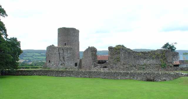
Today, Castell Dinas exists primarily as ruins, with much of its stone walls crumbling and partially obscured by earth. Nevertheless, significant features remain visible, including the outlines of the curtain walls, square towers, and the original well. These remnants offer a tangible connection to the castle's medieval past and its defensive capabilities.

The site also preserves the extensive Iron Age earthworks, including ditches and ramparts, which surround the castle ruins. These features collectively illustrate the site's long history of occupation and strategic use, spanning from prehistoric times through the medieval period.

The castle's elevated position provides commanding views over the surrounding landscape, including the Black Mountains and the town of Talgarth, extending towards Brecon. This vantage point underscores the castle's original purpose as a guardian of mountain passes and a symbol of feudal authority.

Castell Dinas in cultural and heritage contexts

As one of the highest castles in Wales, Castell Dinas holds a unique place in British castle history. Its combination of Iron Age fortifications and Norman stone architecture exemplifies the evolution of defensive structures over centuries. The castle's turbulent history reflects the broader struggles between Welsh princes and English monarchs during the medieval era.

Today, Castell Dinas is a site of archaeological and historical interest, attracting visitors who seek to explore its ancient earthworks and medieval ruins. Its preservation as a hill castle offers valuable insights into military architecture, feudal governance, and regional history in Wales.

Visitors to Castell Dinas can appreciate the blend of natural beauty and historical significance, with panoramic views enhancing the experience of this evocative and enduring landmark.

Frequently asked questions (FAQ)

How do I get to Castell Dinas?
Castell Dinas is located in Talgarth, United Kingdom. You can reach the castle by car, with parking available nearby, or by taking public transport to Talgarth and walking a short distance to the castle site.
What is the historical significance of Castell Dinas?
Castell Dinas dates back to the 12th century and played a key role in the defense of the region during the medieval period. It is an important example of Welsh castle architecture and reflects the turbulent history of the area.
When was Castell Dinas built?
Castell Dinas was constructed in the 12th century, making it one of the oldest castles in Wales. It was likely built as a defensive fortification during the Norman conquest of Wales.
Can I visit Castell Dinas year-round?
Yes, Castell Dinas is open to visitors throughout the year, although specific opening hours may vary by season. It’s advisable to check the official website for the most up-to-date information on visiting hours.
Why is the architecture of Castell Dinas significant?
The architecture of Castell Dinas reflects typical Welsh defensive structures, featuring a motte and bailey design. Its remains give insight into medieval construction techniques and the strategic importance of castles in Wales.
Is it possible to access Castell Dinas with a wheelchair?
While there are some pathways leading to Castell Dinas, the site may not be fully accessible for wheelchair users due to uneven terrain and historical structures. It is recommended to contact the visitor center for specific accessibility information before planning your visit.
What is the best time to visit Castell Dinas?
The best time to visit Castell Dinas is during the spring and early autumn when the weather is generally mild and pleasant. Additionally, the surrounding landscape is particularly beautiful during these seasons, enhancing your experience.
What are the ticket prices for Castell Dinas?
Ticket prices for Castell Dinas are generally affordable, with discounts available for children, students, and seniors. For the latest pricing details, it is best to check the official website or contact the visitor center.
Are there any nearby attractions to Castell Dinas?
Yes, there are several nearby attractions, including the Brecon Beacons National Park, which offers stunning natural scenery and outdoor activities. The charming town of Talgarth itself also features shops, cafes, and historical sites worth exploring.

Information

Hill Castle

Sources & official resources

Verify the information above using these authoritative references.

Loading map...

Visitor reviews

No reviews yet. Been here? Write the first review and help other travelers!

Write the first review

Visited this castle? Share your experience

Your review helps other travelers and adds first-hand knowledge to our encyclopedia.
Write a review

(5/5)

0/2000 characters

Your review will be visible after admin approval

Nearby castles

5.4 km
Bronllys Castle — United Kingdom castle

Bronllys Castle

Talgarth, United Kingdom

Bronllys Castle stands as a significant example of a high medieval motte and bailey fortress located near the village of Bronllys in Powys, Wales. Founded in the early 12th century, this castle played a pivotal role in the complex political and military landscape of the Welsh Marches. Its strategic position south of Bronllys, towards Talgarth, enabled it to serve as a defensive stronghold amid frequent conflicts between Norman lords and Welsh princes. The castle's origins trace back to around 1100 when Richard Fitz Pons, a Norman nobleman and supporter of Bernard of Neufmarché, established the initial wooden fortifications. This early structure typified the motte and bailey design, featuring a raised earthwork (motte) topped with a timber keep and an enclosed courtyard (bailey) surrounded by a protective ditch and palisade. The choice of location leveraged natural topography for defense, with the motte rising approximately 125 meters above sea level in a valley setting. Stone reconstruction and architectural evolution In 1144, the castle underwent a significant transformation when Roger Fitzmiles, Earl of Hereford, detached the land from the Lordship of Brecknock and granted it to Walter de Clifford, son of Richard Fitz Pons. Walter replaced the original wooden structures with stone fortifications, marking a critical evolution in the castle's defensive capabilities. Among the most prominent features from this phase is the round stone tower constructed atop the motte, a robust architectural element designed to withstand sieges and attacks. The round tower is historically notable, especially due to an incident in 1165 when it caught fire. During this event, a stone fell from the battlements, fatally injuring Mahel de Hereford, the last surviving brother of Earl Roger. This tragic episode is recorded by Gerald of Wales, who recounts Mahel's repentance for his persecution of the Bishop of St. Davids as he lay dying. Medieval ownership and political significance Bronllys Castle's ownership reflects the shifting allegiances and power struggles of the medieval Welsh Marches. Following the death of Earl Roger and his brothers, the castle passed through the hands of their sister's husband, Philip de Braose, and subsequently to Eleanor de Braose and her husband, Humphrey de Bohun. The castle was strategically important, evidenced by its defense in 1233 by Walter de Clifford's grandson against an assault led by the Welsh prince Llywelyn ab Iorwerth. Ownership continued to be contested and transferred through marriage and royal favor. In 1311, King Edward II granted the castle to Rhys ap Hywel for his loyalty, though it was later reclaimed by the crown. King Edward III subsequently awarded Bronllys to Humphrey de Bohun, reinforcing the castle's role as a prize of political allegiance. The death of Humphrey in 1373 led to disputes over the estate until Henry Bolinbroke (later King Henry IV) secured it through marriage in 1399. Military role during the glyndŵr rising and decline During the early 15th century, Bronllys Castle was fortified in response to the Glyndŵr Rising, a major Welsh rebellion against English rule led by Owain Glyndŵr. Despite these efforts to strengthen the castle's defenses, it was never again occupied after this turbulent period. The castle's military significance waned as political stability shifted and new forms of warfare emerged. The castle's decline accelerated in the early 16th century. Following the execution of Edward Stafford, 3rd Duke of Buckingham in 1521, Bronllys was forfeited to the crown. That same year, the antiquarian John Leland documented the castle's dilapidated state, noting its advanced disrepair. By 1583, the ruins had further deteriorated, reflecting centuries of neglect. Architectural remains and preservation Today, Bronllys Castle's remains offer a window into its medieval past. The site retains the classic motte and bailey layout, with the motte prominently rising above the surrounding landscape. The stone round tower on the motte remains the most significant surviving structure, illustrating the transition from timber to stone fortifications typical of the 12th century. The castle's location is characterized by a valley setting surrounded by hills, including a notable hill rising to 677 meters about 5.3 kilometers northeast. The nearby town of Brecon lies approximately 12 kilometers southwest. The physical remains, though fragmentary, clearly communicate the castle's defensive role and its architectural evolution over time. Bronllys Castle is currently under the care of Cadw, the historic environment service of the Welsh Government. It is open to the public seasonally, from April to October, allowing visitors to explore the ruins and appreciate the site's historical significance. Despite its ruinous condition, the castle remains a vital cultural landmark, reflecting the rich medieval heritage of the Welsh borderlands.

High Medieval (11th–13th c.)
Details
8.9 km
Tretower Castle — United Kingdom castle

Tretower Castle

Tretower, United Kingdom

Tretower Castle stands as a remarkable example of a medieval motte and bailey castle located in the village of Tretower, Wales. Founded in the early 12th century, it reflects the Norman expansion into the upper Usk valley, illustrating the evolution of military architecture from timber fortifications to stone keeps. Its strategic location atop a natural hill provided commanding views and defensive advantages, characteristic of hill castles from the High Medieval period. The castle's origins trace back to around 1100 when a Norman follower named Picard, serving under Bernard de Neufmarché, constructed a wooden motte and bailey to secure Norman control. This initial timber structure was typical of early Norman fortifications designed for rapid construction and immediate defense. By approximately 1150, Picard's son, Roger Picard I, replaced the wooden motte with a stone shell keep, marking a significant upgrade in fortification. The shell keep formed an irregular circular enclosure atop the motte, with a gate tower oriented along the approach from the bailey. This stone construction provided enhanced durability and defensive capability against siege warfare. Architectural evolution and key features The 13th-century cylindrical keep Between 1230 and 1240, Roger Picard II, the great-grandson of Roger Picard I, undertook major reconstruction by demolishing the inner walls of the shell keep and raising the outer walls to create a large cylindrical stone keep within the original enclosure. This keep rises three storeys above a strong slanted batter (talus), a defensive feature designed to deflect projectiles and prevent undermining. The keep's entrance is located on the first floor, a common Norman design to enhance security. Access to the upper floors was provided by staircases built within the thick walls, maximizing interior space and defensive strength. A decorative string course marks the top of the talus, adding an architectural flourish to the otherwise austere defensive structure. The bailey and curtain walls The castle's bailey, a roughly triangular enclosure to the east of the motte, was fortified with stone curtain walls and cylindrical corner towers by the early 13th century. These walls enclosed the outer ward, protecting the castle's support buildings and providing an additional defensive layer. Although much of the curtain wall has fallen into ruin, archaeological remains and incorporated 18th-century farm buildings reveal the original layout and extent of the fortifications. The bailey was originally surrounded by a water-filled moat fed by natural wetlands, enhancing the castle's defensibility by complicating direct assaults. Internal structures and domestic adaptations Inside the shell keep and cylindrical tower, archaeological excavations have uncovered a ground-floor hall and kitchen area, indicating the castle's role not only as a fortress but also as a noble residence. The lord's private chambers occupied the upper western part of the keep, featuring decorative stone carvings and architectural details typical of 12th-century design. This blend of military and domestic architecture reflects the dual purpose of such castles during the medieval period. Originally, a battlemented walkway or wall walk ran along the outer walls, connected to the keep's second floor by a wooden bridge. This allowed defenders to move safely between the keep and curtain walls during an attack. Over time, as the castle's military importance waned, residential buildings were constructed away from the original fortifications, forming the nearby Tretower Court in the early 14th century. This manor house became the favored residence of the lords, signaling a shift from martial to domestic priorities. Historical significance and ownership Tretower Castle played a notable role during the turbulent 15th century, particularly during the Welsh revolt led by Owain Glyndŵr. The castle was defended by Sir James Berkeley, an English royal supporter, against Welsh attacks. To bolster its defenses, new structures were likely added northwest of the motte to house a reliable garrison during this period. Ownership passed to the Herbert family in the 15th century, with William Herbert transferring the estate to his half-brother Roger Vaughan around 1450. Vaughan is credited with building Tretower Court, which became the principal residence, reflecting the declining military role of the castle. By the 16th century, the castle fell into disuse, and its stones were repurposed for agricultural buildings, including an 18th-century farmhouse constructed within the bailey. Preservation and current condition The castle suffered significant damage in the 20th century, including a major collapse of the shell keep walls in 1947. Subsequently, the site was acquired by the state, which undertook restoration and stabilization efforts during the 1960s. Today, Tretower Castle is a Grade I-listed ruin, recognized for its historical and architectural significance. The remains showcase a layered history of Norman military architecture evolving into a noble residence, with surviving elements of the shell keep, cylindrical keep, curtain walls, and bailey walls. The castle's position on a natural hill, combined with its stone fortifications and water defenses, exemplifies the strategic considerations of medieval castle design. Visitors can explore the ruins and gain insight into the Norman conquest of Wales, the architectural innovations of the High Medieval period, and the social transformations that led to the castle's decline and adaptation. Visiting and educational value Today, Tretower Castle serves as a valuable cultural heritage site, offering educational opportunities about medieval military architecture and Norman history in Wales. Its well-preserved ruins allow for detailed study of motte and bailey construction, shell keeps, and cylindrical Norman keeps. The juxtaposition of military and domestic structures illustrates the changing functions of castles through the centuries. The castle's setting in the picturesque village of Tretower enhances its appeal, providing visitors with a tangible connection to the medieval past within the Welsh landscape. Interpretive materials and guided tours help contextualize the site's history and architecture, making it an important destination for both historians and tourists interested in medieval Britain.

High Medieval (11th–13th c.)
Details
12.5 km

Crickhowell Castle

Crickhowell, United Kingdom

Crickhowell Castle is a notable High Medieval hill castle located in the town of Crickhowell, Wales. Its origins date back to around 1121, when the Norman lord Robert Turberville established a strategic motte-and-bailey fortress overlooking the confluence of a tributary stream and the River Usk. The castle’s elevated position on a spur of land allowed it to dominate the surrounding landscape and the emerging town below, which was planned to grow around its presence. Today, the castle stands largely in ruins, with visible remains of its earthwork motte, stone curtain walls, and defensive towers, reflecting its evolution from timber fortifications to a substantial stone stronghold. Early construction and turberville family influence The initial construction of Crickhowell Castle was typical of Norman military architecture, featuring a wooden motte-and-bailey design. The motte is oval-shaped and remains a prominent earthwork today, while the original wooden structures have long since disappeared. The Turberville family, tenants under the powerful Marcher lord Bernard de Neufmarché, held the castle for over a century and a half. During this period, notable figures such as Henry de Turberville, who served as Seneschal of Gascony, and Hugh Turberville, a military commander under King Edward I, played significant roles in both the castle’s history and the wider military campaigns in Wales and Gascony. Military engagements and strategic role In 1172, the castle was attacked by Welsh rebels led by Seisyllt ap Rhirid, highlighting its strategic importance in the contested borderlands between Norman-controlled territories and Welsh principalities. Later, Hugh Turberville was instrumental in training Welsh men-at-arms and commanding a force of 6,000 infantry in King Edward I’s campaigns to conquer Wales. His leadership underscored the castle’s role as a military hub in the turbulent Welsh Marches during the late 13th century. Stone fortifications and architectural evolution The castle underwent significant transformation beginning in 1242 when Sybil Turberville, daughter of Hugh Turberville, married Sir Grimbold Pauncefote. This marriage brought the castle into the possession of the Pauncefote family, who replaced the earlier wooden defenses with substantial stone fortifications. These included a stone shell keep atop the motte, a curtain wall enclosing the bailey, and multiple stone towers that strengthened the castle’s defensive capabilities. The transition to stone construction was part of a broader trend in medieval castle building, reflecting advancements in military architecture and the need for more durable defenses against increasingly sophisticated siege tactics. Castle layout and surviving remains The castle’s layout featured a classic motte-and-bailey arrangement, with the oval motte serving as the primary defensive mound. Beneath the motte’s surface lie the foundations of the stone shell keep, which are largely buried and require archaeological excavation to fully reveal. The bailey was protected by a substantial stone curtain wall with several towers, including a large tower at the southeast corner where the bailey meets the motte. The gatehouse on the southwest side was flanked by two round towers, of which one remains prominently visible today. Ownership changes and decline During the 14th century, Crickhowell Castle became part of the extensive holdings of the powerful Mortimer family, Marcher Lords who controlled large territories in the Welsh borderlands. However, the castle declined in prominence as it became a smaller holding within their vast portfolio of lands and castles. The castle’s strategic importance diminished, and maintenance likely decreased during this period. Refortification and destruction in the 15th century In 1400, amid rising tensions and rebellion led by Owain Glyndŵr, the castle was refortified by Sir John Pauncefote, the great-grandson of Sir Grimbold Pauncefote. This effort was ordered by the new King Henry IV to strengthen royal defenses in Wales. Despite these efforts, Glyndŵr’s forces attacked and largely destroyed Crickhowell Castle around 1403. The castle was never rebuilt after this destruction and was gradually dismantled, with its stones repurposed for local buildings. Archaeological significance and current condition Today, Crickhowell Castle is a Grade I listed building and a Scheduled Monument, recognized for its historical and architectural importance. The ruins include the earthwork motte, fragments of the stone curtain wall, and surviving towers. Archaeological investigations have identified traces of the bailey in adjacent playing fields, offering insights into the castle’s original extent. The castle ruins lie within the modern town center, serving as a public green space and a tangible link to the Norman conquest and medieval history of Wales. Misidentified structures and historical clarifications Previously, a structure known as the “Ivy Tower” was thought to be part of the castle’s medieval fortifications. However, archaeological studies have clarified that this tower dates from a much later period and is unrelated to the original castle defenses. This distinction helps focus attention on the authentic medieval remains and their conservation. Crickhowell Castle remains a significant example of Norman military architecture in Wales, illustrating the transition from timber to stone fortifications and the complex history of Marcher lordship, military conflict, and royal authority in the Welsh Marches from the 12th to the 15th centuries.

High Medieval (11th–13th c.)
Details