Tap o' Noth
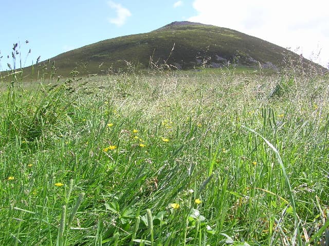
Tap o' Noth is a prominent hillfort located on a hilltop approximately 8 miles south of Huntly in Aberdeenshire, Scotland. It is notable as the second highest fort in Scotland and is distinguished by its well-preserved vitrified walls that enclose a compact area of about 0.3 hectares (approximately 100 meters by 30 meters). The vitrification process, involving the intense heat-fusing of stone ramparts, is a rare and intriguing feature of this fortification, indicative of complex construction techniques in the ancient period.
Archaeological significance and discoveries
The site has yielded important archaeological artefacts that span a wide chronological range, including a stone axe head dated between circa 2000 BC and 800 BC, and a decorated bronze rein-ring from the 1st to 3rd century AD. These finds highlight the long-term significance of the location, suggesting human activity and occupation over several millennia.
Tap o' Noth is designated as a scheduled monument, recognizing its cultural and historical importance. The fort's vitrified walls form the core of a larger settlement area enclosed by an outer rampart, which encloses approximately 7 hectares. This outer enclosure was constructed in the 5th to 6th centuries AD, placing it firmly in the early medieval period and contemporary with the Pictish culture of Scotland.
Settlement layout and scale
Recent archaeological investigations, including drone photography and lidar surveys, have revealed the extensive scale of the settlement around Tap o' Noth. Evidence suggests the presence of up to 800 huts, often organized in groups with a larger hut at the center, indicating a complex social structure. This makes Tap o' Noth the largest known settlement in early medieval post-Roman Britain.
The settlement's layout, with multiple hut groups, suggests a community with defined social or familial units, possibly with a hierarchical organization centered around the larger huts. This reflects a significant population and a high degree of social complexity during the early medieval period.
Historical context and regional connections
In the nearby valley, the discovery of the Pictish image of Rhynie Man on a standing stone at Barflat farm connects Tap o' Noth to wider regional Pictish culture. Excavations in the valley have uncovered a post-Roman settlement with evidence of Mediterranean wine consumption, glass vessels from western France, and intensive metalworking. These findings indicate a community of high social status, possibly with royal or elite connections during the early medieval period.
The proximity of Tap o' Noth to this high-status center at Rhynie suggests a network of power and influence in the region during the 5th and 6th centuries AD.
Decline and historical challenges
Archaeological interpretations have proposed that the decline of the Tap o' Noth settlement and the associated high-status center at Rhynie may have been influenced by broader climatic and epidemiological events. The Late Antique Little Ice Age (LALIA) and the Justinian plague epidemics of the mid-6th century AD likely precipitated a subsistence crisis that affected the population and stability of the region.
This hypothesis situates Tap o' Noth within the wider context of early medieval societal transformations and challenges across Europe during this turbulent period.
Archaeological investigations and research history
The site was first excavated in the 1880s by the antiquarian James Macdonald, who focused on the vitrified fort on the summit. More recent archaeological work has been undertaken by the University of Aberdeen's Northern Picts: Rhynie Environs Project between 2017 and 2022. This project has explored the summit fort, the larger enclosing rampart, and numerous Pictish-period house platforms within the settlement.
These investigations have greatly expanded understanding of Tap o' Noth's scale, structure, and cultural importance, revealing it as a key site for studying early medieval Scotland and Pictish civilization.
Frequently asked questions (FAQ)
- How do I get to Tap o' Noth hillfort?
- Tap o' Noth is located about 8 miles south of Huntly in Aberdeenshire, Scotland. Visitors typically access the site via local roads and walking paths; detailed directions can be found through regional tourist information centers.
- What makes Tap o' Noth's vitrified walls unique?
- The vitrified walls of Tap o' Noth are notable for their construction involving intense heat that fused the stones together. This rare method of fortification is distinctive and provides insight into ancient building techniques.
- When was Tap o' Noth primarily occupied?
- The main settlement at Tap o' Noth dates to the early medieval period, specifically the 5th to 6th centuries AD, with evidence of earlier activity dating back to the Bronze Age.
- Can I see evidence of Pictish culture at Tap o' Noth?
- Yes, Tap o' Noth is closely connected to Pictish culture, and nearby finds such as the Rhynie Man stone and post-Roman settlements reflect the area's significance during the Pictish era.
- Is Tap o' Noth accessible for visitors?
- The site is accessible to visitors, though it involves walking over uneven terrain on the hill summit. Appropriate footwear and preparation for outdoor conditions are recommended.
Photo gallery

Information
Loading map...
Visitor reviews
No reviews yet. Been here? Write the first review and help other travelers!
Write the first reviewVisited this castle? Share your experience
Your review helps other travelers and adds first-hand knowledge to our encyclopedia.