Scrabo Tower

Scrabo Tower: a Victorian memorial tower in County Down
Newtownards, Northern Ireland, United Kingdom
Modern (19th–20th c.)
Partially Restored

Scrabo Tower is a prominent Victorian-era monument located on a hill west of Newtownards in County Down, Northern Ireland. Despite its medieval appearance, the tower was constructed in 1857 during the Modern period as a commemorative structure rather than a defensive fortress. It stands as a memorial to Charles Stewart, 3rd Marquess of Londonderry, a notable military figure who served as a general under the Duke of Wellington during the Napoleonic Wars.

Architectural design and features

The tower was designed by the acclaimed architects Charles Lanyon and W.H. Lynn, who were responsible for several significant buildings in Northern Ireland. The structure reaches a height of approximately 38 meters and features a distinctive turreted design that evokes the style of a medieval castle keep, although it was never intended for military use.

Scrabo Tower is built primarily from locally sourced stone, giving it a robust and imposing presence on the landscape. The design incorporates crenellated battlements, narrow slit windows, and a square tower form, all of which contribute to its castle-like silhouette. However, these elements are purely decorative, reflecting the Victorian fascination with medieval architecture and romanticism rather than practical defense.

Historical context and significance

The tower was commissioned by the local community and the Londonderry family to honor the 3rd Marquess, who was also a prominent landowner and politician in the region. Charles Stewart was known for his military service as well as his influence in the development of the area, including agricultural improvements and infrastructure projects.

Constructed during the mid-19th century, Scrabo Tower exemplifies the Victorian trend of building monumental memorials that combined historical styles with contemporary engineering. It reflects the period's interest in commemorating notable figures through grand architectural statements situated in prominent natural settings.

Location and surroundings

Scrabo Tower stands within Scrabo Country Park, a public park that offers scenic views over Strangford Lough and the surrounding countryside. Its elevated position on a hill provides panoramic vistas, making it a popular spot for visitors and locals alike.

The parkland around the tower includes walking trails, woodlands, and open spaces, enhancing the visitor experience. The tower's location was carefully chosen to maximize its visual impact and to serve as a landmark visible from a considerable distance.

Visitor information and current condition

Historically, Scrabo Tower was open regularly to visitors, allowing access to its interior and the viewing platform at the top. However, after suffering significant water damage in 2014, the tower's accessibility has been limited. It now opens only on select days, with ongoing conservation efforts aimed at preserving the structure.

Visitors to Scrabo Tower can enjoy the surrounding park and the impressive exterior of the tower year-round. The site remains an important cultural and historical landmark in County Down, attracting those interested in Victorian architecture, local history, and natural beauty.

Architectural legacy and cultural importance

Scrabo Tower is a notable example of Victorian commemorative architecture that blends romantic medieval revival styles with 19th-century craftsmanship. Its design by Charles Lanyon and W.H. Lynn places it among the significant architectural works of the era in Northern Ireland.

The tower continues to symbolize the legacy of the Londonderry family and their impact on the region's history. It also serves as a reminder of the Victorian era's fascination with historical revivalism and the use of architecture to express social and political ideals.

Frequently asked questions (FAQ)

How do I get to Scrabo Tower?
Scrabo Tower is located in Newtownards, Northern Ireland, and is easily accessible by car or public transport. There is ample parking available nearby, and local bus services run regularly from Belfast and surrounding areas.
What is the historical significance of Scrabo Tower?
Scrabo Tower was built in 1857 as a memorial to the 3rd Marquis of Londonderry and stands as a symbol of the area's rich heritage. It is also a prominent landmark, offering insights into the historical landscape of County Down and its architectural styles.
When was Scrabo Tower built?
Scrabo Tower was constructed between 1855 and 1857, designed by architect Charles Lanyon. It has stood for over 160 years, serving both as a historical monument and a popular visitor attraction.
Can I climb to the top of Scrabo Tower?
Yes, visitors can climb to the top of Scrabo Tower. The ascent involves navigating a spiral staircase with 122 steps, rewarding climbers with panoramic views of Strangford Lough and the surrounding countryside.
Why is Scrabo Tower an important architectural site?
Scrabo Tower is designed in a Scottish Baronial style, which is notable for its distinctive features and unique design elements. Its impressive stonework and towering presence make it an iconic example of 19th-century architecture in Northern Ireland.
Is it possible to visit Scrabo Tower year-round?
Yes, Scrabo Tower is open to visitors year-round, although opening hours may vary seasonally. It is advisable to check ahead for specific visiting times and any potential closures due to weather conditions.
What are the ticket prices for Scrabo Tower?
Admission to Scrabo Tower is free, making it an accessible attraction for all visitors. Donations are welcomed to help support the maintenance and preservation of the tower and surrounding grounds.
What is the best time to visit Scrabo Tower?
The best time to visit Scrabo Tower is during the spring and summer months when the weather is generally milder and the surrounding gardens are in full bloom. Early mornings or late afternoons can provide a quieter experience and stunning views during sunrise or sunset.
Are there any nearby attractions to visit?
Yes, there are several nearby attractions, including the beautiful landscapes of Strangford Lough and the historic town of Newtownards. Visitors may also enjoy the nearby Mount Stewart House and Gardens, which is a short drive away and offers a rich cultural experience.

Information

Hill Castle

Address

203a Scrabo Rd, Newtownards, County Down, Northern Ireland

Loading map...

Visitor reviews

No reviews yet. Been here? Write the first review and help other travelers!

Write the first review

Visited this castle? Share your experience

Your review helps other travelers and adds first-hand knowledge to our encyclopedia.

Write a review

(5/5)

0/2000 characters

Your review will be visible after admin approval

Nearby castles

7.8 km

Stormont Castle

Belfast, United Kingdom

Stormont Castle is a distinguished mansion located in east Belfast, Northern Ireland, known primarily for its role as the main meeting place of the Northern Ireland Executive. Despite its name, it was never a medieval castle but rather a grand residence extensively remodeled in the 19th century in the Scottish baronial architectural style. This style is characterized by ornamental features such as bartizans, which are small overhanging turrets used here purely for decorative purposes rather than defense. Architectural evolution and style The original building that became Stormont Castle dates back to the early 19th century, with the current structure completed around 1830. The remodeling embraced the romanticized Scottish baronial style, which was popular in Victorian Britain. This style drew inspiration from medieval castles and tower houses, incorporating elements like battlemented parapets, turrets, and crow-stepped gables, which lend Stormont Castle its distinctive silhouette. However, unlike true castles, these features served aesthetic and symbolic functions rather than military purposes. Historical significance and political role Stormont Castle holds a pivotal place in the political history of Northern Ireland. From 1921 to 1972, it served as the official residence of the Prime Minister of Northern Ireland. Interestingly, many prime ministers preferred to reside at Stormont House, the official residence of the Speaker of the House of Commons of Northern Ireland, which was often unoccupied because several speakers chose to live elsewhere. Despite this, Stormont Castle was the site of the Cabinet Room where key governmental decisions were made during this period. Following the suspension of the Northern Ireland Parliament in 1972, Stormont Castle became the Belfast headquarters for the Secretary of State for Northern Ireland, Northern Ireland Office ministers, and their supporting officials. This transition marked its continued importance as a center of governance and administration. Role during the troubles and security During the turbulent period known as the Troubles, Stormont Castle also played a significant security role. It was used by MI5 officers as a base of operations, reflecting its strategic importance within Northern Ireland's political and security landscape. The castle's robust and imposing architecture complemented its function as a secure government facility during these challenging decades. Public access and cultural heritage While Stormont Castle primarily functions as a government building, it opens its doors to the public annually during the European Heritage Open Day weekend. This event allows visitors to explore the castle's historic interiors and grounds, gaining insight into its architectural features and the political history it embodies. The castle's location on the Stormont Estate, which includes other government buildings and parkland, makes it an important cultural and historic landmark in Belfast. Location and surroundings Situated in the Stormont Estate in east Belfast, Stormont Castle is surrounded by extensive parklands and gardens. The estate itself is a significant green space in the city, providing a tranquil setting that contrasts with the castle's formal governmental role. The location was chosen for its prominence and accessibility, reinforcing the castle's status as a seat of power in Northern Ireland. Architectural features in detail Stormont Castle's design includes several characteristic elements of the Scottish baronial style. The bartizans at the corners of the building are among the most notable features, projecting from the upper walls and capped with conical roofs. The castle also features steeply pitched roofs, tall chimneys, and mullioned windows that contribute to its historic appearance. Inside, the interiors reflect the building's governmental use, with formal rooms such as the Cabinet Room designed for official meetings and administrative functions.

Modern (19th–20th c.)
Details
9.8 km

Mahee Castle

Comber, United Kingdom

Mahee Castle stands as a remarkable example of a 16th-century fortified tower house located on Mahee Island near Comber, Northern Ireland. Built in 1570 by Captain Thomas Browne, an English settler and soldier, the castle was strategically positioned to control access to the island via a causeway and to oversee a volatile border region between the Gaelic lordships of Clandeboye and Dufferin. This placement underscores its importance in the political and military landscape of late Renaissance-period Ireland. The castle's construction reflects the typical architectural features of a Renaissance-era tower house, a common form of fortified residence in Ireland during the 16th century. Mahee Castle's rectangular footprint measures approximately 12.2 meters by 6.7 meters, with thick stone walls up to 1.8 meters wide, designed to withstand attacks and harsh weather. Originally rising to three stories, today only the lower portions remain, standing nearly 7.6 meters high. Its location atop a glacial drumlin provided natural elevation and defense advantages. Historical context and strategic significance During the late 16th century, the area surrounding Mahee Island was a contested frontier between the Gaelic lordships of Clandeboye to the north and Dufferin to the south. Both regions were frequently engaged in territorial disputes and skirmishes, making the control of key access points like the causeway to Mahee Island militarily vital. The castle's establishment by Captain Thomas Browne, with the permission of the Bishop of Down, was part of a broader English effort to consolidate influence and secure strategic positions in Ireland during a period of political unrest. Mahee Castle likely changed hands multiple times amid the conflicts that characterized this borderland. Its abandonment by the early 17th century reflects the shifting political and military realities as English control expanded and the need for such isolated strongholds diminished. The reuse of stone from the castle by locals to repair nearby structures and the causeway illustrates the castle's decline and the practical adaptation of its materials. Architectural features and layout Tower house structure The core of Mahee Castle is its tower house, a rectangular stone building with robust defensive characteristics. The walls, measuring 1.5 meters thick on most sides and 1.8 meters on the southeast, were built to resist siege and weathering. The ground floor contains two vaulted chambers: a larger room with a semicircular vault supported by a central wooden beam, and a smaller room with a pointed vault formed on reed mats, likely used for storage. These vaulted ceilings demonstrate skilled masonry techniques of the period. Defensive elements The entrance, located in the northwest wall, is approximately 1.1 meters wide and features a murder-hole above the doorway, a defensive opening through which defenders could attack assailants attempting to breach the entrance. Adjacent to the doorway, a staircase provided access to the upper floors, which would have included living quarters and defensive positions. Surrounding fortifications Archaeological evidence reveals that Mahee Castle was surrounded by a walled enclosure or bawn to the southwest, serving as a courtyard for protection and possibly for livestock. Additionally, the castle complex included a boat bay along the lakeshore, highlighting its role in controlling local waterways and facilitating transport or defense by water. Preservation and archaeological investigations By the early 1600s, Mahee Castle had fallen into disuse and disrepair. Local inhabitants repurposed stones from its walls for other constructions, accelerating its ruin. Recognizing the cultural and historical value of the site, conservation efforts began in the late 19th century, culminating in a significant restoration in 1923 led by H.C. Lawlor and the Belfast Natural History and Philosophical Society. These works included the removal of invasive vegetation such as ivy, filling cracks with cement to prevent water infiltration, and applying a waterproof layer to the roof. A buttress wall was also constructed about four meters from the southwestern edge of the tower to stabilize the terrace and prevent erosion. Further archaeological excavations from 2001 to 2002, directed by Ruaíri Ó Baoill and Philip Macdonald, uncovered a range of artifacts including animal bones, pottery shards from various periods, flint tools, knives, shells, and fragments of modern glass. These findings suggest continuous or intermittent occupation and activity on the site over several centuries. The excavations also indicated that earlier fortifications may have existed before the 1570 tower house was constructed, providing valuable insight into the site's long-term strategic importance. Architectural significance and cultural heritage Mahee Castle exemplifies the Renaissance tower house typology common in Ireland, combining residential and defensive functions in a compact stone structure. Its strategic location on an artificial terrace atop a drumlin, overlooking a causeway and waterways, illustrates the integration of natural landscape features into defensive planning. The castle's surviving architectural elements, such as the vaulted chambers and murder-hole, are characteristic of the period's military architecture. Today, Mahee Castle remains a partially preserved ruin that offers valuable insights into the turbulent history of late medieval and early modern Ireland. It stands as a testament to the English colonial presence in Ulster during the late 16th century and the complex interactions between Gaelic and English powers. The site continues to attract interest from historians, archaeologists, and visitors intrigued by its historical context and architectural features. Visiting mahee castle Located near the village of Comber in Northern Ireland, Mahee Castle is accessible to visitors interested in exploring historic sites. While the castle is a ruin, the conservation efforts have stabilized the structure enough to allow safe viewing of the tower and its surroundings. Visitors can appreciate the castle’s strategic position and learn about its history through interpretive signage available on site. The nearby Nendrum Monastery adds to the area's rich heritage, making Mahee Island a compelling destination for those interested in medieval and Renaissance history. Visitor tips Wear sturdy footwear as the terrain around the castle includes uneven ground and a drumlin hill. Check local access conditions, especially during wet weather, as the causeway can be slippery. Combine a visit to Mahee Castle with nearby historical sites such as Nendrum Monastery for a fuller experience. Photography enthusiasts will find the ruins and surrounding landscape particularly picturesque.

Renaissance (15th–17th c.)
Details
10.7 km
Grey Point Fort — United Kingdom castle

Grey Point Fort

, United Kingdom

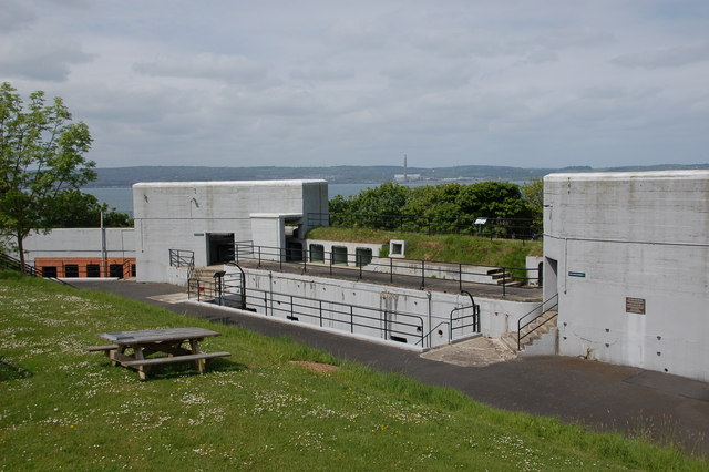
Grey Point Fort is a historic coastal defence battery located at Helen's Bay on the south side of Belfast Lough in Northern Ireland. Constructed in the early 20th century, it formed a key part of the defensive network protecting Belfast and its important maritime approaches. Its strategic position allowed it to control naval access to Belfast, a vital industrial and shipbuilding hub, particularly during the two World Wars. Construction and early armament The battery's construction began in 1904 and the main artillery pieces were installed by 1907. Grey Point Fort was equipped with two 6-inch Mark VII breech-loading guns, which were state-of-the-art coastal artillery at the time. These guns were mounted in protected emplacements designed to withstand naval bombardment and provide a commanding field of fire across Belfast Lough. The fort's design reflects the principles of a bastioned fortress, with reinforced concrete gun positions and defensive earthworks. The Owen Report of 1905 specifically noted the construction of this battery alongside a counterpart at Kilroot on the opposite side of the Lough, emphasizing its role in a coordinated defensive system. Role during the first world war During the First World War, Grey Point Fort's role expanded beyond artillery. Additional buildings were constructed to accommodate men from Kitchener's Army, reflecting the increased military presence and the fort's importance in coastal defence. The fort helped protect Belfast's shipyards and maritime infrastructure from potential enemy naval threats. Interwar period and modernization Following the war, Grey Point Fort remained operational and underwent upgrades. In 1936, two coastal defence searchlights were installed to enhance night-time targeting capabilities. These improvements were part of broader efforts to modernize coastal defences in response to evolving military technology and threats. Second world war enhancements and operations During the Second World War, Grey Point Fort was manned by the 525th (Antrim) Coast Regiment, Royal Artillery, a Territorial Army unit. The fort's gun emplacements were further reinforced with concrete overhead covers to protect the artillery and crews from aerial attack and shellfire. This period marked the fort's peak operational readiness, as it stood guard against the threat of German naval and air attacks on Belfast and surrounding areas. Post-war period and decommissioning After the war, Grey Point Fort continued to serve a defensive role. In 1954, a mobile radar installation was added, reflecting the shift towards modern electronic surveillance in coastal defence strategies. However, with the abolition of coast artillery in 1956, the fort was officially disarmed and ceased to function as an active military installation. Restoration and current status Between 1992 and 1996, efforts were made to restore the fort's historic artillery capability. Two original guns were sourced from coastal fortifications in County Cork—one from Fort Mitchel on Spike Island and the other from Fort Davis. These guns were installed at Grey Point Fort, enhancing its value as a heritage site and a tangible link to Britain's coastal defence history. Since 2008, the fort has been opened to the public by the Grey Point Amateur Radio Society. It now serves as a cultural and historical landmark, offering visitors insight into early 20th-century military architecture and coastal defence systems. The site provides educational opportunities and a glimpse into the technological and strategic developments that shaped Britain's maritime security during two world wars. Architectural features and design Grey Point Fort exemplifies the characteristics of a bastioned fortress built in the early 20th century. Its design incorporates reinforced concrete gun emplacements with protective overhead covers added during WWII. The layout includes ammunition storage facilities, crew quarters, and observation posts, all integrated within earthworks that blend with the natural landscape to reduce visibility and maximize defence. The fort's two main gun positions are spaced to provide overlapping fields of fire across Belfast Lough, enabling effective control of naval traffic. The addition of searchlights and later radar installations demonstrates the evolution of coastal defence technology implemented at the site. Historical significance and heritage value Grey Point Fort holds significant historical value as part of the United Kingdom's early 20th-century coastal defence network. It illustrates the transition from traditional artillery fortifications to more modern, technology-integrated military installations. The fort's continuous use through both world wars and the Cold War era highlights its strategic importance. Today, Grey Point Fort stands as a well-preserved example of a bastioned coastal battery and serves as a reminder of Belfast's maritime and military heritage. Its restoration and public accessibility contribute to the understanding of coastal defence history and the broader narrative of Britain's military preparedness during periods of global conflict.

Contemporary (20th–21st c.)
Details