HM Fort Roughs
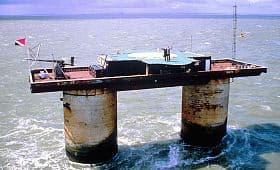
HM Fort Roughs is a distinctive example of a 20th-century bastioned fortress designed for maritime defense during World War II. Constructed under the direction of engineer Guy Maunsell, it is one of the several Maunsell Sea Forts built to protect the strategic Thames estuary and the port of Harwich, Essex. These forts were part of the United Kingdom's coastal defense system against aerial and naval threats, particularly from German forces during the war.
The fort is an artificial naval installation weighing approximately 4,500 tons, and its design shares similarities with the structural principles of fixed offshore oil platforms. It is situated on Rough Sands, a sandbar located about 11 kilometres (6 nautical miles) from the Suffolk coast and 13 kilometres (7 nautical miles) from the Essex coast. This remote location was chosen to maximize its defensive range over the estuary approaches.
Architectural design and structural features
The design of HM Fort Roughs reflects the practical and strategic needs of its time. The fort consists of multiple interconnected towers mounted on concrete caissons that rest on the seabed, providing a stable foundation in the challenging marine environment. The towers include gun platforms, radar installations, and living quarters for the garrison.
The fortress features bastioned elements typical of fortifications intended to provide overlapping fields of fire. Its robust concrete and steel construction was intended to withstand bombardment and harsh weather conditions. The design also incorporated anti-aircraft guns and radar technology, which were advanced for the period and crucial for early warning and defense against enemy aircraft and naval vessels.
Historical context and wartime role
During World War II, the Maunsell Sea Forts played a vital role in the defense of the United Kingdom's eastern coast. HM Fort Roughs was specifically tasked with guarding the approaches to the Thames estuary, a critical maritime route for shipping and naval operations. The forts were manned by Royal Navy personnel and equipped to engage enemy aircraft and surface vessels.
Though their active military use was relatively brief, the forts represented an innovative approach to coastal defense. They combined naval and air defense capabilities in a single offshore platform, which was unusual for the era. After the war, the military significance of these forts diminished with advances in radar and missile technology.
Post-war history and the emergence of sealand
Following their decommissioning, HM Fort Roughs and the other Maunsell Sea Forts were largely abandoned. However, in 1967, the fort gained international attention when it became the site of the self-proclaimed micronation known as the Principality of Sealand. The fort's owner declared independence from the United Kingdom, establishing a unique political entity on the platform.
Sealand has since become a cultural curiosity and a symbol of sovereignty claims on offshore structures. While not officially recognized by any government, it has maintained a continuous presence on HM Fort Roughs and has been involved in various legal and political disputes over its status.
Current condition and accessibility
Today, HM Fort Roughs remains structurally intact but is considered a partially preserved military installation. Its remote offshore location makes access challenging, typically requiring boat transport. The fort is not open to the general public, but it attracts interest from historians, military enthusiasts, and those intrigued by the story of Sealand.
The fort's design and history offer valuable insights into mid-20th-century military engineering and coastal defense strategies. It stands as a rare example of offshore fortifications that transitioned from wartime use to a unique form of civilian occupation.
Architectural legacy
The Maunsell Sea Forts, including HM Fort Roughs, influenced later offshore engineering projects, particularly in the development of oil platforms and maritime installations. Their innovative use of concrete caissons and modular towers demonstrated effective methods for building stable structures in deep water.
Despite their limited active military lifespan, these forts remain significant for their engineering achievements and their role in the history of coastal defense.
Frequently asked questions (FAQ)
- What is HM Fort Roughs and why was it built?
- HM Fort Roughs is a World War II Maunsell Sea Fort built to defend the Thames estuary and the port of Harwich from enemy attacks.
- Where is HM Fort Roughs located?
- It is located on Rough Sands, a sandbar approximately 11 kilometres from the Suffolk coast and 13 kilometres from the Essex coast in the United Kingdom.
- Can the public visit HM Fort Roughs?
- Due to its offshore location and private ownership, HM Fort Roughs is not generally open to the public and access is limited.
- What is the Principality of Sealand?
- The Principality of Sealand is a self-proclaimed micronation established in 1967 on HM Fort Roughs, claiming independence from the United Kingdom.
- What architectural features characterize HM Fort Roughs?
- The fort features interconnected concrete towers on caissons, bastioned defensive elements, gun platforms, radar installations, and living quarters.
Photo gallery

Photo by See en:Talk:Sealand/emails•Public domain
Information
Architect
Guy Maunsell
Loading map...
Visitor reviews
No reviews yet. Been here? Write the first review and help other travelers!
Write the first reviewVisited this castle? Share your experience
Your review helps other travelers and adds first-hand knowledge to our encyclopedia.