Fort Binġemma — Malta castle

Fort Binġemma

Fort Binġemma: a polygonal bastioned fortress in Malta
Rabat, Malta
Modern (19th–20th c.)
Partially Preserved

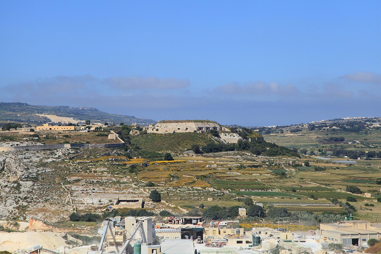
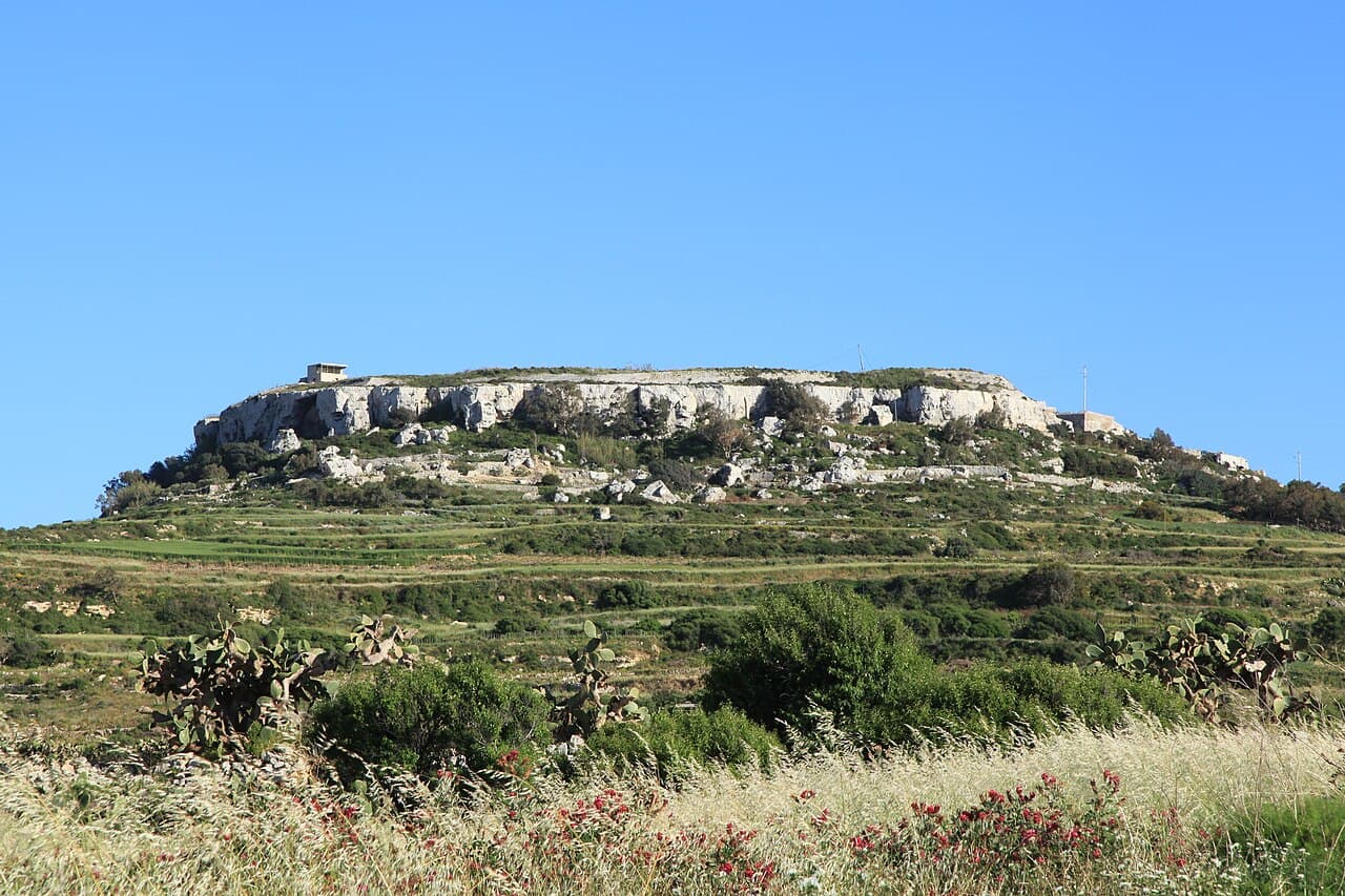
Fort Binġemma, also known historically as Fort Bin Jema or Fort Bengemma, is a polygonal bastioned fortress located within the limits of Rabat, Malta. Constructed between 1875 and 1878 by the British military, it formed a key component of the Victoria Lines, a defensive line designed to protect the northern part of Malta from potential invasion. The fort stands on a prominent hill approximately 180 meters (590 feet) above sea level, providing strategic views over the surrounding landscape.

Architectural design and military purpose

The fort exemplifies polygonal fortification principles that were prevalent in the 19th century, reflecting advances in military engineering. Unlike traditional medieval castles with high curtain walls and towers, Fort Binġemma features low, angled bastions designed to deflect artillery fire and provide overlapping fields of fire. Its bastioned design allowed defenders to cover all approaches with cannon and rifle fire.

The fort's layout includes thick defensive walls and earthworks that absorb and mitigate the impact of enemy bombardments. The design was intended to withstand the artillery technology of the period, with a focus on defense against infantry assaults and artillery bombardment.

Historical context and construction

Fort Binġemma was built as part of the British Empire's efforts to strengthen Malta's defenses during the late 19th century. The Victoria Lines were a series of fortifications constructed along a natural escarpment to create a defensive barrier across the island. This line of defense aimed to protect the more densely populated southern areas from northern invasion routes.

The site of Fort Binġemma was chosen due to its commanding position and existing historical significance. Archaeological evidence indicates that a Roman village once existed on the site, highlighting the area's long-term strategic importance. The British military capitalized on this elevated ground to maximize surveillance and defense capabilities.

Later history and recent events

In the 21st century, Fort Binġemma became notable for an unusual episode when it was illegally occupied by the Buttigieg family from 2009 until 2025. During this period, the family occasionally operated a restaurant within the fort's premises, despite the lack of official authorization. This occupation ended in 2025 when the authorities evicted the occupants, restoring control over the historic site.

Today, Fort Binġemma remains a significant example of British military architecture in Malta, illustrating the adaptation of fortification design to the evolving demands of modern warfare in the 19th century. Its preservation offers insights into the strategic military planning of the British Empire and the historical defense of Malta.

Geographical and cultural significance

Perched on a hilltop, Fort Binġemma commands views of the surrounding Maltese countryside, underscoring its role in surveillance and defense. The fort's location within the limits of Rabat places it near several other historical sites, contributing to the rich cultural landscape of the region.

The fort is part of Malta's broader military heritage, reflecting the island's importance as a strategic naval and military base throughout history. Its connection to the Victoria Lines situates it within a network of fortifications that collectively represent a significant chapter in Malta's defensive architecture.

Frequently asked questions (FAQ)

What is the historical significance of Fort Binġemma?
Fort Binġemma is a 19th-century fortification built by the British as part of their defense strategy for Malta. It played a crucial role during World War II, serving as a lookout and observation post. Today, it stands as a testament to Malta's military history and architectural evolution.
When is the best time to visit Fort Binġemma?
The best time to visit Fort Binġemma is during the spring (March to May) and autumn (September to November) months. These seasons offer milder weather, making it more comfortable for exploring the fort and enjoying its panoramic views. Summer can be quite hot, while winter is generally mild but may bring occasional rain.
Can I access Fort Binġemma by public transport?
Yes, you can reach Fort Binġemma by public transport, though options may be limited. The nearest bus stop is in Rabat, from where you can take a short walk to the fort. It is advisable to check local bus schedules for the most convenient routes.
What are the opening hours for Fort Binġemma?
Fort Binġemma is typically open to the public from 9 AM to 5 PM, but it is essential to verify current hours before your visit, as they may vary seasonally or due to special events. Guided tours may also have specific time slots, so planning ahead is recommended.
Is it possible to take guided tours of Fort Binġemma?
Yes, guided tours of Fort Binġemma are available and provide valuable insights into the fort's history and architecture. The tours often include access to areas that are not open to the general public, enhancing your experience. It is advisable to book in advance, especially during peak tourist seasons.
What are the ticket prices for visiting Fort Binġemma?
Entry to Fort Binġemma is usually free, but some special guided tours may have a nominal fee. Always check the official website or local tourist information for the latest pricing and any special offers. This makes it an accessible option for all visitors.
Are there any nearby attractions to visit after Fort Binġemma?
Yes, after visiting Fort Binġemma, you can explore other nearby attractions such as the Mdina Old City and the Roman Villa. Both sites offer rich historical experiences and stunning architecture, making them perfect complements to your visit. Be sure to allocate time to enjoy the scenic views and quaint streets of Mdina.
What architectural features can I expect to see at Fort Binġemma?
Fort Binġemma showcases classic military architecture, including thick walls, a star-shaped layout, and strategically placed gun emplacements. The fort's design reflects the military engineering of the time, emphasizing both defense and functionality. Visitors can admire these features while enjoying the breathtaking views of the surrounding landscape.

Photo gallery

Fort Binġemma
Click to view

Photo by Frank Vincentz•CC BY-SA 3.0

1 photo • Click any image to view in full screen

Information

Bastioned Fortress

Current owner

Government of Malta

Loading map...

Visitor reviews

No reviews yet. Been here? Write the first review and help other travelers!

Write the first review

Visited this castle? Share your experience

Your review helps other travelers and adds first-hand knowledge to our encyclopedia.
Write a review

(5/5)

0/2000 characters

Your review will be visible after admin approval

Nearby castles

4.2 km

Fortifications of Mdina

Mdina, Malta

Mdina, often called the "Silent City," is a fortified city in Malta with a history of fortification dating back to antiquity. The fortifications of Mdina are among the best-preserved defensive walls in Malta, showcasing a complex layering of historical periods from the Punic-Roman era through the Medieval and Hospitaller periods. These fortifications have been continuously adapted and expanded to meet evolving military needs over nearly two millennia. Ancient origins and early fortifications The origins of Mdina's fortifications trace back to around 700 BC when the Phoenicians established the city of Maleth on one of Malta's highest points, strategically situated away from the coast to protect it from seaborne attacks. This early settlement was fortified with defensive walls that enclosed a larger area than the current city, extending into what is now the town of Rabat. Under Roman rule, the city was renamed Melite, and the fortifications continued to serve as a vital defensive structure. During the Byzantine period in the early Middle Ages, the fortifications underwent significant modifications. A retrenchment was constructed within the city, reducing its size to the current perimeter of Mdina. The Byzantines likely built a fortification at the southeast corner near the main entrance, which later became known as the Castellu di la Chitati. This period marked a transition from the expansive Punic-Roman defenses to a more compact and defensible urban core. Arab and medieval transformations In approximately 870 AD, the Maltese Islands fell under Arab rule. The city was renamed Medina, from which the modern name Mdina derives. The Arabs are credited with initiating the digging of the city's defensive ditch, a key feature that enhanced the fortifications by creating a moat-like barrier around the walls. Following the Norman conquest in 1091, Malta became part of the County of Sicily, and a succession of feudal lords controlled the island. During this medieval period, Mdina's fortifications were expanded and reinforced. The land front featured a series of double walls fortified by four main towers, including the Turri Mastra near the main gate and the Turri di la Camera at the southeast corner. By the 15th century, the city walls reflected medieval military architecture, designed to withstand siege warfare typical of the period. The fortifications included thick curtain walls, battlements, and fortified towers, which provided vantage points for archers and artillery. The impact of artillery and the hospitaller renovations The introduction of gunpowder and artillery in the early 16th century necessitated major upgrades to Mdina's defenses. By 1522, the walls began to be adapted to withstand cannon fire. The medieval fortifications were largely dismantled and rebuilt by the Order of Saint John (the Hospitallers) from the 16th through the 18th centuries, reflecting the evolution of military engineering and the need to counter Ottoman threats. During the reign of Juan de Homedes y Coscon, significant improvements were made to the fortifications. Mdina successfully resisted a brief Ottoman attack in 1551, demonstrating the effectiveness of these upgrades. Later, after the Great Siege of Malta in 1565, the city played a role in deterring Ottoman forces retreating from the failed siege of the Grand Harbour by firing their cannons despite limited ammunition. 18th-century enhancements and architectural features The 17th and 18th centuries saw further fortification works under the Hospitallers. The construction of the De Redin Bastion in the 17th century added a formidable defensive position. The early 18th century brought modernization efforts led by the architect Charles François de Mondion, who redesigned the main gate, the area around Greeks Gate, and other parts of the fortifications, enhancing both their defensive capabilities and aesthetic appeal. Despuig Bastion was constructed between 1739 and 1746 during the reign of Ramon Despuig, completing the bastioned fortifications that characterize Mdina today. These bastions provided overlapping fields of fire and were designed to absorb and deflect artillery bombardment. The fortifications include an irregular perimeter of thick curtain walls reinforced by five bastions, all built during the Hospitaller period. The Torre dello Standardo, built in 1725 on the site of the medieval Turri Mastra, served as a signalling tower to communicate with coastal watchtowers, integrating Mdina into the wider defensive network of the island. Historical significance and preservation Mdina's fortifications have survived largely intact, with the exception of some outworks, making them one of the best-preserved examples of fortified medieval and early modern urban defenses in Malta. The city walls reflect a continuous history of military architecture adapting to changing political and military contexts from the ancient Phoenician foundation to the Hospitaller enhancements. Mdina has been on Malta's tentative list of UNESCO World Heritage Sites since 1998, recognizing its cultural and historical importance. Archaeological excavations have uncovered foundations of the ancient Punic-Roman ramparts and various medieval remains, providing valuable insights into the city's long defensive history. In the late 19th century, Mdina's fortifications were considered part of the Victoria Lines, a defensive line built by the British across northern Malta, illustrating the continued strategic importance of the site well into modern times.

Post-Renaissance (17th–18th c.)
Details
5.2 km

Tal Virtu Castle

Rabat, Malta

Tal Virtu Castle, also known as Palazzo Virtu, stands prominently in the Tal-Virtu area of Rabat on the island of Gozo, Malta. This early 20th-century castle is a remarkable example of the period's architectural style and offers visitors a commanding 360-degree panoramic view of the island and surrounding Mediterranean landscape. Historical context and location The Tal-Virtu area is renowned for its rich cultural heritage and picturesque environment. The castle is situated near the historic Rotonda chapel dedicated to Santa Maria, which dates back approximately 500 years, highlighting the area's long-standing religious and architectural significance. The proximity of these two landmarks underscores the blend of historical eras represented in this part of Gozo. Architecture and design features Tal Virtu Castle was constructed in the early 20th century, reflecting architectural trends of that era rather than medieval fortification styles. Unlike traditional medieval castles, it was designed more as a grand residence or palace, embodying elements of palatial architecture with an emphasis on aesthetic appeal and comfort. The castle's design includes expansive terraces and balconies that maximize the breathtaking views of Gozo's countryside and coastline. Its construction materials and stylistic details align with the architectural movements prevalent in Malta during the early 1900s, which often incorporated neoclassical and eclectic influences. Comparison to other Maltese palaces A similar structure was built in the Ta' Qali area of Malta; however, that palace was destroyed during the bombings of the Second World War. Tal Virtu Castle remains one of the few surviving examples of this architectural type from that period, contributing to its cultural and historical value. Significance and current status Today, Tal Virtu Castle is recognized not only for its architectural beauty but also for its strategic location that offers visitors an exceptional vantage point over Gozo. The castle's preservation allows for continued appreciation of early 20th-century Maltese architecture within a setting that also honors the island's deeper historical layers. Its status as a well-preserved palatial castle makes it an important landmark in Gozo's cultural landscape, attracting visitors interested in both history and architecture. Nearby attractions and cultural heritage Visitors to Tal Virtu Castle can also explore the nearby Rotonda chapel of Santa Maria, which adds a significant historical dimension to the visit. The chapel's half-millennium history offers insights into the religious and social fabric of Gozo across centuries. The surrounding area of Rabat is rich with other historical sites, traditional Maltese architecture, and natural beauty, making Tal Virtu Castle a prime starting point for cultural and heritage tourism on the island.

Post-Renaissance (17th–18th c.)
Details
6.1 km
Fort Mosta — Malta castle

Fort Mosta

Mosta, Malta

Fort Mosta, also known historically as Fort Musta and in Maltese as Il-Fortizza tal-Mosta, is a significant example of British military architecture in Malta. Constructed between 1878 and the 1880s, this polygonal bastioned fortress was built as part of the extensive Victoria Lines, a defensive line designed to protect the northern part of the island from invasion. Located in the town of Mosta, the fort played a strategic role in the island's defense system during the 19th century and into the early 20th century.Historical context and strategic importanceThe construction of Fort Mosta was driven by the British military’s need to strengthen Malta’s defenses against potential threats, particularly from the north. The Victoria Lines were a series of fortifications stretching across the island, taking advantage of the natural ridge to create a formidable barrier. Fort Mosta was one of the key bastions within this system, designed to control access through the northern approaches and to serve as a stronghold in case of an attack.During the late 19th century, Malta was a crucial naval base for the British Empire, and its fortifications reflected the evolving military technologies and strategic doctrines of the period. Fort Mosta’s design reflects the shift from traditional medieval-style castles towards modern polygonal forts, which emphasized low-profile, angular bastions and thick walls to better resist artillery fire.Architectural features and designFort Mosta is characterized by its polygonal layout, a hallmark of the bastioned fortress style favored in the 19th century. Unlike earlier medieval castles with high walls and towers, polygonal forts were designed with angled bastions that eliminated blind spots and allowed defenders to cover all approaches with overlapping fields of fire.The fort’s walls are constructed from robust limestone, a common building material in Malta, providing durability and resistance to bombardment. The design incorporates dry moats and glacis—sloping earthworks that protect the walls and expose attackers to defensive fire. The entrance is fortified with a gatehouse and defensive outworks to delay and disrupt enemy advances.Inside, the fort includes barracks, ammunition magazines, and various service buildings arranged around a central parade ground. These internal structures were built to support a garrison capable of sustained defense and to store the necessary supplies and armaments.Adaptations and later useWhile originally built for active defense, Fort Mosta’s role evolved over time. It was never tested in a major siege but remained a critical part of Malta’s military infrastructure through both World Wars. Today, the fort is still in use by the Armed Forces of Malta, primarily as an ammunition depot, reflecting its continued strategic value.Preservation and current conditionFort Mosta is well preserved, maintaining much of its original structure and defensive features. Unlike many other historical fortifications that have fallen into ruin, this fort remains intact and functional, a testament to the quality of its construction and ongoing maintenance.Its status as an active military site means that public access is limited, but the fort remains an important cultural and historical landmark within Malta’s rich heritage of fortifications. It offers valuable insights into the military architecture of the British colonial period and the island’s strategic significance in the Mediterranean.Fort Mosta in the context of Maltese fortificationsMalta’s fortifications are renowned worldwide for their scale and historical importance, ranging from medieval castles to massive coastal batteries. Fort Mosta represents a later phase in this defensive tradition, illustrating the transition from classical bastioned forts to polygonal designs adapted to modern artillery.Its inclusion in the Victoria Lines connects it to a broader network of defenses that shaped Malta’s military landscape in the 19th century. This network was part of the British Empire’s efforts to secure its naval dominance in the Mediterranean, making Fort Mosta a key piece in the island’s defense puzzle.

Modern (19th–20th c.)
Details