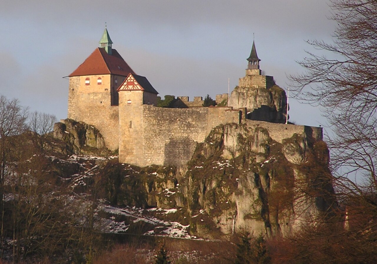
Burgruine Osternohe
Burgruine Osternohe stands as a compelling example of a high medieval hill castle strategically positioned above the village of Osternohe near Schnaittach in Bavaria, Germany. This fortress, constructed by local nobility tied to the Holy Roman Empire, played a significant role in regional administration and military history from the 12th through the 18th centuries.
The castle's earliest documented mention dates back to 1169, linked to the noble figure Poppo de Osternahe. Although it remains unclear whether the family initially resided in the hilltop fortress or a nearby motte-and-bailey structure, by 1228 the castle itself is explicitly referenced as "castrum Osternach" in a royal document confirmed by King Heinrich VII. The Osternohe family belonged to the upper echelon of imperial ministerials, knights who served as administrators and military officers under the emperor. Among them, Poppo IV is particularly notable for his participation in the 1229 crusade led by Emperor Frederick II, his role in the 1241 Battle of Liegnitz against Mongol invaders, and his tenure as Grand Master of the Teutonic Order from 1253 to 1257.
The castle's architectural evolution and features
Burgruine Osternohe is perched at approximately 515 meters elevation on a rocky spur of the Schlossberg ridge, oriented southwest. The fortress is divided into two main sections: the upper castle, which remains accessible and offers panoramic views, and the lower castle, largely privately owned and closed to the public.
The most architecturally significant remnant is the bergfried, or main tower. Historical depictions from 1773 reveal the bergfried's outer walls constructed of large, finely cut ashlar blocks, indicative of early 13th-century masonry techniques. Unusually, the bergfried was originally built with a pentagonal plan, a rare design among medieval towers that typically favored circular or rectangular shapes. However, during restoration efforts in 1968, the bergfried's form was altered to a square tower stump, simplifying its original complex geometry.
The castle's defensive layout includes an outer bailey or lower defensive courtyard, which was historically vulnerable and suffered damage during conflicts. The upper castle housed administrative and residential buildings, underscoring the fortress's dual military and governmental functions.
Historical significance and ownership transitions
In 1254, ownership of the castle shifted when Engelhard de Osterna sold it to Gottfried von Hohenlohe. Throughout the 14th century, the castle became associated with the Neidunge family and a steward known as Vogt Wolfram von Osternohe. By 1354, a burgrave's Vogt was stationed here, marking the castle as an important local administrative center. From 1385, Burgruine Osternohe served as a burgravial seat, overseeing judicial and fiscal responsibilities, and by 1427 it functioned as a margravial administrative hub.
The castle endured significant military strife during the First Margrave War in 1450, when Nuremberg forces burned the outer bailey. Restoration was undertaken starting in 1457 by Hans von Egloffstein, a margravial bailiff who resided at the castle into the late 15th century. Further devastation occurred during the Second Margrave War in 1553, when mercenaries plundered and set fire to the fortress. Despite this, the castle was rebuilt by 1573 and continued its role as a margravial administrative center until 1722.
Decline and preservation efforts
After 1722, the castle's administrative office was dissolved and merged with the Oberamt Pegnitz in 1766, marking the end of its official use. By this time, the castle was already in a state of disrepair and uninhabitable. A lightning strike after 1766 damaged the bergfried, and local residents quarried stones from the ruins for other building projects. A detailed map of the castle ruins was created in 1816 by Johann Christoph Stierlein, preserving knowledge of its layout.
Efforts to demolish the castle ruins in the early 19th century were prevented by the historian Hellmut Kunstmann. In 1968, restoration work was undertaken on the bergfried, although the tower's original pentagonal shape was replaced with a square stump. Today, much of Burgruine Osternohe remains in decay, with the bergfried and upper castle outlines standing as silent witnesses to its layered history.
Regional context and strategic importance
Burgruine Osternohe is part of a dense network of medieval fortifications in the region. Nearby castles include Burg Hohenstein to the east, and the former castles of Riegelstein, Spies, and Wildenfels to the north. To the west and southwest lie the sites of Hienberg and Alter Rothenberg, while the fortress of Rothenberg is located approximately four kilometers to the south. This concentration of castles highlights the strategic significance of the area during the Middle Ages, serving as defensive strongholds and centers of noble administration.
While the lower castle area remains largely inaccessible and less documented, the surviving structures of the upper castle and the bergfried offer valuable insights into the architectural and historical development of medieval hill castles in Bavaria. Burgruine Osternohe exemplifies the integration of military defense, noble residence, and administrative function that characterized many such fortresses in the Holy Roman Empire.
Frequently asked questions (FAQ)
- When was Burgruine Osternohe originally built?
- Burgruine Osternohe was constructed during the High Middle Ages, with its earliest records dating back to 1169 and significant architectural features dating from around 1200.
- What is unique about the bergfried of Burgruine Osternohe?
- The bergfried originally had a rare pentagonal plan, uncommon among medieval towers, though it was altered to a square tower stump during restoration in 1968.
- Can visitors access the entire castle site?
- The upper castle area of Burgruine Osternohe is open to the public and offers scenic views, but the lower castle area is mostly privately owned and not accessible.
- What historical events impacted the castle?
- The castle suffered damage during the First Margrave War in 1450 and the Second Margrave War in 1553, including burning and plundering by troops and mercenaries.
- How did the castle's administrative role evolve over time?
- Burgruine Osternohe served as a burgravial seat from 1385 and later as a margravial administrative center from 1427 until its office was dissolved in 1766.
Information
Loading map...
Visitor reviews
No reviews yet. Been here? Write the first review and help other travelers!
Write the first reviewVisited this castle? Share your experience
Your review helps other travelers and adds first-hand knowledge to our encyclopedia.