Ashdod-Sea Fortress
Ashdod-Sea Fortress stands as a remarkable testament to the region's dynamic history, showcasing layers of occupation and architectural evolution from the 7th century CE through the Crusader period. Located in the municipality of Ashdod, Israel, this fortress was strategically constructed under the Umayyad Caliph Abd al-Malik to serve as a vital coastal defense installation. Its primary role was to protect the southern stretch of the coastal plain and to function as an early warning system for the nearby provincial capital of Ramla against naval threats, particularly from the Byzantine Empire.
Historical context and strategic importance
The fortress's origins in the early Islamic period highlight its significance in the Umayyad military network. Built during a time of expanding Islamic control, Ashdod-Sea Fortress was part of a broader system of fortifications designed to secure maritime routes and coastal settlements. Its location enabled surveillance over the Mediterranean Sea, providing critical intelligence and defense against potential Byzantine incursions.
By the 10th century, under the rule of the Fatimid Caliphate, the fortress experienced substantial expansion and reinforcement. Renamed Qal’at al-Mina or "Port Fortress," it became a fortified maritime outpost crucial for monitoring sea traffic and defending the coastline. This period saw the integration of Islamic architectural and military innovations, enhancing the fortress's defensive capabilities.
The fortress's resilience was tested in 1033 when a powerful earthquake inflicted severe damage, particularly to its entrance towers. Despite this setback, the site remained operational and was later adapted by the Crusaders following their successful campaigns in the region. By 1099, the Crusaders had fortified the structure further, renaming it Castellum Beroart or Beroartum, in honor of Nicholas de Beroart, a knight linked to the Lordship of Ramla. The fortress continued to serve as a key military stronghold throughout the 12th and 13th centuries during the Crusader presence in the Levant.
Following the 1260 Mamluk conquest and the collapse of the Crusader Kingdom, the fortress was abandoned as a military installation. Over subsequent centuries, it transitioned into a refuge for nomadic groups, its ruins silently narrating the region's turbulent history of conquest and cultural exchange.
Architectural features and layout
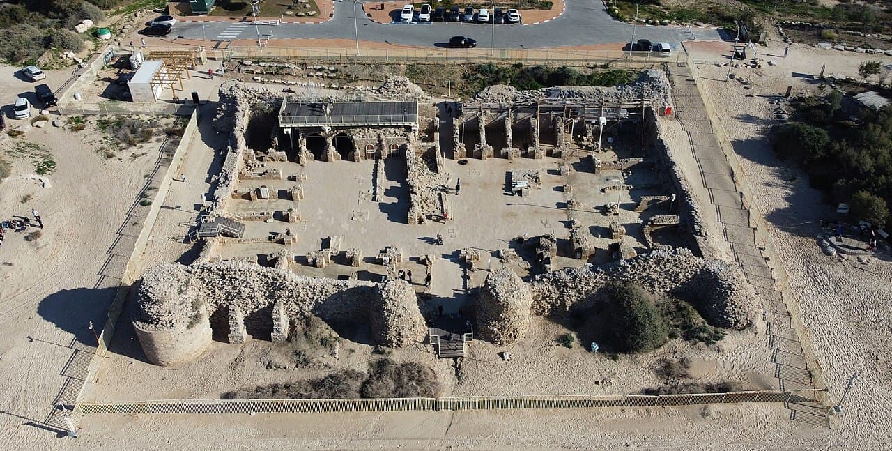
The fortress occupies an area approximately 60 meters by 45 meters, enclosed by robust walls constructed from kurkar, a calcareous sandstone native to the coastal region. These walls originally supported six round towers about eight meters tall, strategically positioned to protect vital access points. The western side, facing the sea, was guarded by four towers, including two flanking the main sea gate, while the eastern side featured two round towers and two additional square towers at the eastern corners, reinforcing the fortress's landward defenses.
A distinctive moat surrounds the fortress on the landward side, crossed by a bridge leading to the eastern gate. This defensive feature underscores the fortress's dual role in guarding against threats from both sea and land. Despite centuries of exposure to harsh sea winds and the seismic impact of the 1033 earthquake, significant portions of the walls and towers remain visible, offering insight into the fortress's original imposing presence.
Internal structures and facilities
Within the fortress, the layout centers around a central courtyard, which was surrounded by various chambers serving multiple functions. These included residential quarters, stables for horses, and a mosque, reflecting the fortress's Islamic heritage during the Umayyad and Fatimid periods. Archaeological excavations have revealed two wells to the north and south of the courtyard, emphasizing the critical importance of a reliable water supply in sustaining the garrison and inhabitants.
To the north of the courtyard lies a well-preserved bathhouse featuring plaster-coated pools and an advanced water heating system. This facility aligns with the Islamic tradition of bathhouses (hammams) common in military and urban centers, highlighting the cultural and practical aspects of life within the fortress.
Preservation and modern significance
Modern conservation efforts have focused on stabilizing the remaining structures by reinforcing walls and clearing accumulated sands that had obscured parts of the site. Renovations include renewed flooring to facilitate visitor access and the construction of an elevated wooden observation platform, offering panoramic views of the fortress ruins and the surrounding coastal landscape.
The fortress is part of a broader historical and ecological complex that includes a nearby signaling tower located in present-day Ashdod's Quarter 15. Together, these sites formed an ancient communication network essential for coastal defense. Adjacent to the fortress lies an ecological park that preserves both natural habitats and remnants of the ancient Ashdod-Sea city, linking the fortress to its wider historical and environmental context.
Cultural heritage and tourism
Ashdod-Sea Fortress today is recognized not only for its military and architectural significance but also as a cultural heritage site that embodies the layered history of the southern Levant. It attracts scholars, archaeologists, and tourists interested in the intersection of Islamic, Crusader, and local histories. The site offers a tangible connection to the past, illustrating the strategic importance of coastal fortifications in medieval geopolitical struggles.
Visitors can explore the fortress ruins, learn about its historical phases, and appreciate the sophisticated defensive and residential features that sustained its occupants over centuries. The integration of natural and historical elements in the surrounding ecological park enhances the visitor experience, providing a serene environment that complements the fortress's historical narrative.
Frequently asked questions (FAQ)
- How do I get to Ashdod-Sea Fortress?
- Ashdod-Sea Fortress is located in Ashdod, Israel, accessible by local transportation and car. Visitors should check local travel guides for the best routes and parking options.
- What is the historical significance of Ashdod-Sea Fortress?
- Ashdod-Sea Fortress played a crucial role as a coastal defense installation from the Umayyad period through the Crusader era, protecting maritime routes and nearby cities.
- Can I visit the fortress ruins?
- Yes, the fortress ruins are open to visitors. Modern conservation efforts have improved access with pathways and observation platforms to enhance the visitor experience.
- When was the fortress built and by whom?
- The fortress was originally constructed in the 7th century CE under Umayyad Caliph Abd al-Malik as part of coastal defenses against Byzantine threats.
- What architectural features can I see at the fortress?
- Visitors can observe robust kurkar stone walls, round and square towers, a moat with a bridge, a central courtyard, wells, a mosque, and a bathhouse with ancient water heating systems.
Photo gallery

Information
Website
Visit websiteSources & official resources
Verify the information above using these authoritative references.
Loading map...
Visitor reviews
No reviews yet. Been here? Write the first review and help other travelers!
Write the first reviewVisited this castle? Share your experience
Your review helps other travelers and adds first-hand knowledge to our encyclopedia.