Tibrandsholm Castle Ruins

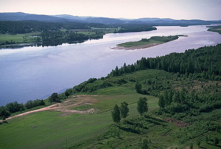
Tibrandsholm Castle ruins in Krokom, Sweden
Krokom, Sweden
Late Medieval (14th–15th c.)
Archaeological Site

Tibrandsholm Castle ruins stand as a silent witness to a turbulent chapter in Swedish history, located near Krokom in Jämtland County, Sweden. Dating back to the late medieval period, around 1390, the castle's origins and purpose remain partly shrouded in mystery. The first documented mention of the castle appears in 1402, when Margaret I of Denmark ordered its demolition during the conflicts surrounding the Kalmar Union.

Historical background and ownership

The castle was likely named after its steward, Tibrand, who is believed to have been associated with the Victual Brothers, a group of privateers and pirates active in the Baltic Sea during the late 14th and early 15th centuries. These privateers opposed the Kalmar Union, a political entity uniting Denmark, Norway, and Sweden under a single monarch. Tibrandsholm's strategic location made it a significant military site during this period of regional conflict.

In the 17th century, during the wars between Sweden and Denmark, the ruins of Tibrandsholm served a different purpose as a soldier camp and a place of execution. This later use highlights the site's continued military significance long after the castle itself had fallen into ruin.

Archaeological significance and surrounding settlements

Excavations and studies around Tibrandsholm have revealed evidence of human activity dating back to the Bronze Age, Iron Age, and Viking Age. These findings indicate that the area was inhabited or used for settlement and strategic purposes for many centuries before the castle's construction. The presence of these ancient settlements adds layers of historical depth to the site, making it an important location for understanding the broader history of the region.

Architectural features and castle type

Although only ruins remain today, Tibrandsholm was likely a hill castle, built on elevated terrain to provide defensive advantages. The castle's design would have included typical late medieval fortification features such as thick stone walls, defensive towers, and possibly a moat or ditch. The limited remains make it difficult to reconstruct the full layout, but the strategic location and historical context suggest a fortress built primarily for military defense rather than residential comfort.

Legacy and cultural importance

Tibrandsholm Castle ruins are a valuable cultural heritage site in Sweden, offering insights into the medieval power struggles in Scandinavia and the complex history of the Kalmar Union. The site's archaeological layers contribute to the understanding of continuous human occupation in the region from prehistoric times through the medieval era. Today, the ruins attract historians, archaeologists, and visitors interested in medieval fortifications and Scandinavian history.

Preservation efforts focus on maintaining the ruins as an archaeological site and promoting awareness of its historical significance. While the castle itself no longer stands intact, the surrounding landscape and ruins provide a tangible connection to the past conflicts and cultural developments that shaped northern Sweden.

Frequently asked questions (FAQ)

How do I get to Tibrandsholm Castle Ruins?
Tibrandsholm Castle Ruins is located in Krokom, Sweden, and can be reached by car or public transport from nearby cities. The nearest bus station is a short walk away from the site, making it accessible for visitors without a vehicle.
What is the historical significance of Tibrandsholm Castle Ruins?
Tibrandsholm Castle was built in the late 16th century and served as a noble residence. Its ruins today offer insight into the architectural styles and historical context of the era, making it an important site for those interested in Swedish history.
When was Tibrandsholm Castle constructed?
Construction of Tibrandsholm Castle began in 1580 and was completed in the early 1600s. The castle has undergone various phases of use and decline, with its ruins now standing as a testament to its rich history.
Can I explore the castle ruins on my own?
Yes, visitors are welcome to explore the ruins of Tibrandsholm Castle at their own pace. However, it is recommended to follow any posted guidelines to ensure safety while navigating the site.
Why is Tibrandsholm Castle an important architectural site?
The castle features elements of Renaissance architecture, showcasing the design trends of the period. Its ruins provide valuable insights into early Swedish castle construction and the lifestyle of the nobility during that time.
Is it possible to visit Tibrandsholm Castle year-round?
Yes, Tibrandsholm Castle Ruins are open to visitors throughout the year. However, accessibility may vary depending on weather conditions, so it's best to check local information before planning your visit.
What are the best months to visit Tibrandsholm Castle Ruins?
The best time to visit Tibrandsholm Castle is during the late spring and summer months when the weather is mild and the surrounding landscape is lush. This is also when most visitors enjoy outdoor activities in the area.
Are there any nearby attractions to visit while in Krokom?
Yes, Krokom offers several nearby attractions such as beautiful hiking trails, lakes, and the scenic landscapes of the surrounding region. Visitors can enjoy outdoor activities and explore the natural beauty that Sweden has to offer.
What are the ticket prices for visiting Tibrandsholm Castle Ruins?
There is no admission fee to visit Tibrandsholm Castle Ruins, making it an accessible destination for everyone. However, donations to help maintain the site are always appreciated.
What are the opening hours for Tibrandsholm Castle Ruins?
Tibrandsholm Castle Ruins are open to the public at all times, allowing visitors to enjoy the site whenever they wish. It is advisable to visit during daylight hours for the best experience.

Information

Hill Castle

Loading map...

Visitor reviews

No reviews yet. Been here? Write the first review and help other travelers!

Write the first review

Visited this castle? Share your experience

Your review helps other travelers and adds first-hand knowledge to our encyclopedia.
Write a review

(5/5)

0/2000 characters

Your review will be visible after admin approval

Nearby castles

160.3 km

Stensätter Hill Fort

Bollstabruk, Sweden

Stensätter Hill Fort, also known locally as Stensättersborgen or Borgberget, is among the most well-preserved ancient hill fortifications in the northern Swedish region of Norrland. Situated on a prominent 190-meter-high hill near the small locality of Bollstabruk, this site offers a remarkable example of prehistoric defensive architecture in Scandinavia. The fort's elevated position provided strategic advantages, overseeing the surrounding landscape and controlling movement through the area. Architectural features and fortifications The hill fort is defined by a substantial stone wall that stretches approximately 135 meters in length, enclosing the summit of the hill. This wall measures about 4 meters wide and stands roughly 2.5 meters high, constructed from locally sourced stones carefully arranged to form a robust defensive barrier. The thickness and height of the wall suggest it was built to withstand attacks and to serve as a formidable obstacle to invaders. Unlike many other ancient fortifications, the Stensätter Hill Fort has not yet undergone archaeological excavation, which leaves much about its construction techniques, internal layout, and period of use open to interpretation. However, its preservation state allows for a clear understanding of its defensive purpose and scale. Historical context and significance Hill forts such as Stensätter were typically constructed during the Iron Age in Scandinavia, roughly spanning from 500 BC to 1050 AD. These structures served as refuges during times of conflict and as symbols of territorial control. While the exact dating of Stensätter is unconfirmed due to the lack of excavation, its architectural characteristics align with other known hill forts from the Late Iron Age. The location in Norrland, a region known for its rugged terrain and sparse population historically, indicates the fort could have played a role in local defense strategies or as a gathering place for communities in times of threat. Its preservation contributes valuable insight into the defensive practices of ancient Scandinavian societies. Natural setting and strategic importance Perched atop a high hill, Stensätter Hill Fort utilizes the natural topography to enhance its defensive capabilities. The steep slopes surrounding the site would have made direct assault difficult, forcing attackers to confront the fortified stone wall under disadvantageous conditions. This natural defense combined with man-made fortifications exemplifies the strategic use of landscape in ancient military architecture. The fort's vantage point also allowed for surveillance over the surrounding valleys and routes, enabling early warning of approaching groups or enemies. This would have been critical in an era when communication and rapid mobilization were limited. Preservation and potential for future research Despite its excellent preservation, Stensätter Hill Fort remains largely unstudied archaeologically. Future excavations could reveal important information about its construction phases, the people who built and used it, and the broader cultural context of hill forts in northern Sweden. Such research would contribute to a more comprehensive understanding of Scandinavian prehistory. Currently, the site is accessible to visitors interested in ancient history and archaeology, offering a tangible connection to the region's distant past. Its status as one of the best-preserved hill forts in Norrland makes it a significant cultural heritage site.

Early Medieval (5th–10th c.)
Details
166.2 km
Styresholm — Sweden castle

Styresholm

Kramfors, Sweden

Styresholm fortress is a significant example of a late medieval bastioned fortress located in what is now Kramfors Municipality, Sweden. Originally constructed in the 14th century by the notorious pirate group known as the Victual Brothers, it formed part of a strategic network of fortifications along the Gulf of Bothnia. The fortress's original position was on an island in the Ångermanälven river, which at the time had a water level several metres higher than today, altering its landscape and defensive advantages. Historical context and foundation The Victual Brothers were a pirate confederation active in the Baltic Sea during the late 14th century, known for their maritime raids and control of key trading routes. Styresholm was one of several fortresses they established to secure their stronghold and influence over regional waters. The fortress's earliest recorded mention dates to 1398, coinciding with the transfer of ownership to Queen Margaret I, who ruled the Kalmar Union uniting Denmark, Norway, and Sweden. This transfer marked a shift from pirate control to royal governance, with a Danish governor appointed in 1400 to oversee the fortress and its surrounding territories. Architectural features and strategic importance As a bastioned fortress, Styresholm was designed with angular bastions projecting from its defensive walls, a style that allowed defenders to cover adjacent walls with crossfire and resist siege artillery more effectively than traditional medieval curtain walls. This architectural approach was relatively advanced for its time and reflects the evolving military engineering of the late medieval period. The fortress likely included thick stone walls, moats fed by the river, and fortified gates to control access. Its island location provided natural defense, making it difficult for attackers to mount direct assaults without exposure to defensive fire. Location and environmental changes Styresholm's placement on an island in the Ångermanälven river was a critical defensive feature. Over the centuries, the water level of the river has dropped by several metres, transforming the site from an island fortress to a riverside location. This environmental change has impacted the preservation and visibility of the fortress remains, as well as the surrounding landscape. Political significance and later history Following its acquisition by Queen Margaret I, Styresholm served as a strategic royal outpost in northern Sweden, helping to assert the Kalmar Union's control over the region and secure maritime routes in the Gulf of Bothnia. The appointment of a Danish governor in 1400 underscores its importance as a military and administrative center during this period. Details about Styresholm's later history are sparse, but like many medieval fortresses, it likely experienced periods of decline as military technology and political boundaries evolved. The fortress's role diminished as centralized nation-states developed stronger armies and new fortifications elsewhere. Present condition and archaeological significance Today, Styresholm exists as an archaeological site with limited above-ground remains. The changes in the river's water level and natural erosion have affected the preservation of the fortress's structures. Archaeological investigations have contributed to understanding its layout and historical function, offering insights into 14th-century military architecture and the maritime conflicts of the Baltic region. Styresholm's legacy as a late medieval bastioned fortress built by pirates and later integrated into royal defense systems highlights the complex political and military history of northern Europe during the Middle Ages.

Late Medieval (14th–15th c.)
Details
166.8 km

Hegra Fortress

Stjørdal, Norway

Hegra Fortress is a notable mountain fortress located in Stjørdal, Norway, constructed between 1908 and 1910 as a defensive stronghold following the dissolution of the union between Norway and Sweden in 1905. The fort was built in response to ongoing fears of a Swedish invasion aimed at reclaiming Norwegian territory. Its strategic position at Ingstadkleiva allowed it to serve as a vital border fortification during a tense period in Scandinavian history. Construction and architectural design The fortress was engineered by dynamiting approximately 300 metres of halls and tunnels directly into the mountain rock, creating a complex network of underground passages. These included two main parallel tunnels, each about 80 metres long, connected by a 35-metre tunnel at a right angle. One tunnel was designated for crew quarters, while the other provided direct access to the above-ground artillery pits. The tunnels and chambers were reinforced with concrete to withstand bombardment. The fortifications also featured trench systems and gun positions excavated from the rock using explosives. The artillery complement included two 7.5-centimetre and four 10.5-centimetre positional artillery pieces mounted in half-turrets within rock-cut pits, alongside four Krupp M/1887 field guns. These flat-angle guns had an effective range of 6 to 9 kilometres, providing significant defensive coverage. Military role and operational history From 1910 to 1926, Hegra Fortress functioned as a major military base overseeing the Trøndelag border region with Sweden. However, post-World War I defence budget reductions led to the fort being placed in reserve in 1926. Between 1934 and 1939, the decommissioned fortress served a humanitarian role as a summer holiday camp operated by the Norwegian Red Cross's youth branch. In late 1939, the fortress temporarily housed Finnish soldiers from the independent Lapland Group who had fled fighting in the Petsamo district of northern Finland. During their internment, a sauna was constructed at the camp, reflecting the soldiers' cultural needs. All Finnish internees were repatriated by early 1940. Siege of 1940 and World War II significance Hegra Fortress is best known for its role during the German invasion of Norway in 1940. From 15 April to 5 May 1940, the fortress withstood a prolonged siege by German forces. The initial phase involved two infantry assaults, which were followed by sustained heavy artillery bombardment and Luftwaffe air raids. The defenders also faced aggressive patrolling by German troops. The harsh conditions included heavy snowfall that covered large parts of the fort, complicating defense efforts. Additionally, crucial plans of the fortress were stored in German-occupied Trondheim, so several sections of the fortifications remained unknown to the defenders until the surrender on 5 May. Despite these challenges, the garrison's resistance delayed German control in the region. Post-war preservation and current use After World War II, Hegra Fortress was returned to Norwegian control and has since been preserved as a museum dedicated to its military history, with a particular focus on the 1940 siege. Visitors can explore the underground tunnels, artillery pits, and other defensive structures that illustrate early 20th-century military engineering. The site includes a café, a souvenir shop, and facilities for conferences and seminars on topics related to war and peace. Hegra Fortress remains under the ownership of the Norwegian Defence Force and is funded through the Norwegian Ministry of Defence, ensuring its maintenance and accessibility to the public. Architectural and historical significance Hegra Fortress represents an important example of early 20th-century military architecture adapted to mountainous terrain. Its extensive use of underground tunnels and rock-cut artillery positions exemplifies defensive strategies designed to maximize protection and firepower. The fortress's history reflects Norway's geopolitical concerns following its independence and highlights the impact of World War II on Scandinavian defense structures. Today, the fortress stands as a cultural heritage site that educates visitors about Norway's military past and the broader context of European conflicts in the first half of the 20th century.

Modern (19th–20th c.)
Details