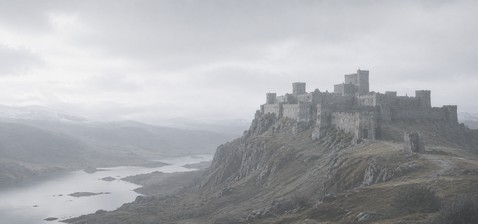
Tepelenë Castle

Tepelenë Castle: historic hill fortress of Albania's Ali Pasha
Tepelenë, Albania
Early Medieval (5th–10th c.)
Partially Preserved

Tepelenë Castle, locally known as Kalaja e Tepelenës, stands prominently on a hill overlooking the confluence of the Drino and Vjosë rivers in the town of Tepelenë, Albania. This hill castle occupies a strategic location that has commanded the surrounding valley for centuries, reflecting the area's enduring military and political significance.

The origins of the fortress trace back to the 7th century, likely built during the Byzantine period. Although detailed records from this early era are scarce, the site was first documented in 1482 when Ottoman Sultan Bayezid II visited the existing castle. This original fortress, probably Byzantine in origin, was destroyed in 1492 during conflicts involving Albanian and Venetian insurgents resisting Ottoman expansion. The Ottomans subsequently constructed a smaller garrison castle nearby, utilizing the ruins of the earlier fortification as building material.

Medieval and ottoman history of tepelenë castle

Throughout the 15th and 16th centuries, Tepelenë Castle played a pivotal role in regional power struggles. Ottoman tax registers from 1520 reveal a mixed community of Christian and Muslim families residing in Tepelenë, alongside a castle garrison of over 180 soldiers, underscoring its military importance. The fortress was a focal point during local rebellions, as evidenced in 1670 when the Ottoman traveler Evliya Çelebi described Tepelenë as a modest settlement with a garrison of approximately 100 soldiers and noted the rebellious nature of surrounding villages.

Strategic significance and local resistance

The castle's location at the junction of two rivers made it a key defensive and administrative site. Despite Ottoman control, the persistent resistance from local communities shaped the fortress's history. The absence of amenities such as hammams or caravanserais in the 17th century highlighted Tepelenë's relative isolation and the ongoing tensions in the region.

Ali pasha's transformation of the fortress

The most transformative period in the castle's history came under Ali Pasha of Tepelenë, an Albanian Ottoman ruler known for his autonomous governance in the late 18th and early 19th centuries. Taking control of Tepelenë in 1789, Ali Pasha initiated extensive expansions of the fortress, incorporating the older Ottoman castle within a much larger and more formidable complex. His construction efforts, largely completed by the early 1800s, included thick defensive walls up to five meters wide and polygonal towers that enhanced the fortress's military capabilities.

Architectural features of ali pasha's fortress

Ali Pasha's fortress covered approximately four hectares and featured three main gates, including the eastern "Vizier Gate," distinguished by a Greek-language inscription dated 1819. The fortress's walls, built using the Cloisonné masonry technique, remain standing to heights of around ten meters. Three polygonal towers at the southeast, southwest, and northwest corners survive intact, exemplifying the robust defensive design of the period.

Within the expanded fortress, the earlier Ottoman castle was repurposed as a storage area. The complex also housed soldier quarters, magazines for weapons and supplies, religious buildings, and a prison. Although Ali Pasha's palace within the castle no longer exists, it was historically significant as the site where the English poet Lord Byron visited in 1809, drawing Western attention to Ali Pasha's rule.

Destruction and preservation

The town of Tepelenë and Ali Pasha's palace suffered devastating damage during a 1920 earthquake. Additionally, the fortress endured plundering by Greek irregular forces in the early 20th century and sustained damage during both World Wars. Despite these challenges, significant portions of the fortress walls, gates, and towers have survived, offering valuable insights into the site's layered history.

Today, Tepelenë Castle is freely accessible and forms part of a quiet residential neighborhood within its walls. Visitors can enjoy panoramic views of the Vjosë valley and explore the remains of this imposing fortress. A notable feature near the castle is a rickety hanging footbridge spanning the Vjosë river, providing a unique vantage point and connection to the surrounding landscape.

Architectural details and construction techniques

The fortress's walls showcase the Cloisonné technique, where stone blocks are framed with bricks to create decorative and structurally sound masonry. Two nearly intact circular towers from the original Ottoman castle stand about five meters high with diameters close to ten meters, illustrating medieval defensive architecture. Remnants of a minaret from a former mosque within the castle grounds highlight the site's religious significance during Ottoman times.

Fortress layout and defensive structures

The older Ottoman castle measured approximately 56 by 40 meters and was enclosed by walls about 350 meters in length. It featured two gates on the northern and eastern sides, parts of which remain visible today. Ali Pasha's expansion multiplied the fortress's size and defensive complexity, adapting it to the evolving military technologies and political realities of the early 19th century.

Cultural significance and legacy

Tepelenë Castle stands as a testament to the region's turbulent history and the legacy of Ali Pasha, whose rule left a lasting imprint on southern Albania. The fortress symbolizes the blend of Byzantine origins, Ottoman military architecture, and early modern Albanian power. A monument dedicated to Ali Pasha near the fortress's main entrance commemorates his influence and the castle's role as one of his two headquarters alongside Ioannina.

Visitors to Tepelenë Castle not only experience a remarkable historic fortress but also gain insight into the complex cultural and political narratives that shaped the Balkans over centuries. The castle's enduring presence offers a tangible connection to Albania's medieval past and its Ottoman heritage, making it a significant site for both history enthusiasts and cultural tourists.

Frequently asked questions (FAQ)

How do I get to Tepelenë Castle?
Tepelenë Castle is located in the town of Tepelenë in Gjirokastër County, Albania. It is accessible by road, with local transport options available from nearby cities such as Gjirokastër and Fier.
What is the historical significance of Tepelenë Castle?
Tepelenë Castle has a rich history dating back to the Byzantine period and played a key role during Ottoman rule, especially under Ali Pasha of Tepelenë in the early 19th century.
Is Tepelenë Castle open to visitors?
Yes, Tepelenë Castle is freely accessible to the public every day without restrictions, allowing visitors to explore its extensive walls, towers, and surrounding views.
What architectural styles are visible at Tepelenë Castle?
The castle features Byzantine origins with significant Ottoman military architecture, including Cloisonné masonry and polygonal towers from Ali Pasha's expansions.
When was Tepelenë Castle expanded by Ali Pasha?
Ali Pasha took control of Tepelenë in 1789 and expanded the fortress extensively in the first two decades of the 19th century, adding thick walls and new defensive towers.
Are there any notable landmarks near Tepelenë Castle?
Near the castle, visitors can find a rickety hanging footbridge over the Vjosë river, offering scenic views of the valley and the fortress itself.

Information

Hill Castle

Opening hours

Open daily, unrestricted

Ticket prices

Free

Current owner

Municipality

Loading map...

Visitor reviews

No reviews yet. Been here? Write the first review and help other travelers!

Write the first review

Visited this castle? Share your experience

Your review helps other travelers and adds first-hand knowledge to our encyclopedia.
Write a review

(5/5)

0/2000 characters

Your review will be visible after admin approval

Nearby castles

2.8 km

Zharë Castle

Tepelenë, Albania

Zharë Castle, locally known as Kalaja e Zharës, is an early medieval fortress situated between the villages of Turan and Veliqot in the county of Gjirokastër, Albania. Positioned strategically on a hill overlooking the valley of the Vjosë river, this castle occupies a commanding location that would have provided control over the surrounding landscape and river routes. Dating back to the 4th to 6th centuries AD, Zharë Castle is believed to have been constructed during the period of the Byzantine Empire, potentially under the reign of Emperor Justinian I. This timing places the castle within the early medieval period, a time when the Byzantine Empire was actively fortifying its territories against various invasions and internal unrest. The castle's origins as a military fortification are supported by its architectural features and archaeological findings. Architectural layout and defensive features The castle has an elongated, elliptical plan adapted to the natural shape of the hill it occupies. Although much of the structure has not survived intact, the remains allow visitors to discern the original defensive walls that once enclosed the fortress. These walls would have been constructed to withstand sieges and protect the inhabitants from attackers. Within the castle's perimeter, archaeological research has uncovered the site of a cistern, an essential feature for water storage during prolonged sieges. The presence of this cistern highlights the strategic planning involved in the castle's design, ensuring a sustainable water supply for its garrison. At the northern end of the castle stands the remains of a square tower, which likely served as a lookout and defensive strongpoint. At the southern and highest point of the castle is a D-shaped tower, a design common in Byzantine military architecture, providing both defensive strength and a commanding view over the surrounding terrain. Historical context and significance Zharë Castle was part of the broader network of fortifications the Byzantine Empire established along its western frontiers to secure key routes and protect against incursions from various groups including Slavs and other tribes. Its location near the Vjosë river valley was strategic for controlling movement through this important corridor in southern Albania. While detailed historical records specifically mentioning Zharë Castle are scarce, its architectural style and dating align it with the defensive efforts during the reign of Justinian I (527–565 AD), who famously undertook a vast program of fortress construction and restoration across the empire. This suggests the castle played a role in the military and administrative control of the region during a turbulent period. Current condition and accessibility Today, Zharë Castle is in a state of ruins, with only partial remains of its walls and towers visible. Despite its modest preservation, the site offers visitors a glimpse into early medieval military architecture and the historical landscape of the region. The castle is freely accessible to the public. A dirt road leads directly from the paved road below up to the heart of the castle grounds, making it relatively easy to visit. Although the ruins themselves may not be as visually striking as larger or more intact castles, the location provides impressive views of the Vjosë river valley and the surrounding hills. Tepelenë Castle, a more prominent fortress, is located nearby and often attracts visitors interested in the area's rich history. Archaeological research and preservation Archaeological investigations have been limited but have confirmed the castle's early medieval origins and its function as a military fortification. The findings of the elliptical layout, towers, and cistern contribute valuable information to the understanding of Byzantine frontier defenses in this part of the Balkans. Preservation efforts have been minimal, and the site remains largely in its natural ruined state. Visitors should be aware that facilities are limited, and the site is best suited for those interested in history, archaeology, and scenic views rather than extensive tourist infrastructure.

Early Medieval (5th–10th c.)
Details
13.8 km

Këlcyrë Saray

Këlcyrë, Albania

Këlcyrë Saray, locally known as Sarajet e Ali Bej Këlcyrës, is a historically significant fortified palace-residence located near the town of Këlcyrë in the Gjirokastër county of Albania. Perched halfway up the steep slope of Trebeshinë Mountain, this site occupies a strategic and visually commanding position overlooking the surrounding landscape. Although often mistaken for a castle due to its imposing ruins, Këlcyrë Saray was not a traditional medieval fortress but rather a fortified palace constructed in the 19th century. It was founded by the prominent Albanian Ottoman ruler Ali Pasha of Ioannina, who exercised considerable autonomy and quasi-independence within the Ottoman Empire during his reign. The palace served as a residence and administrative center for local rulers aligned with Ali Pasha's authority. The historical context of Këlcyrë Saray The location of Këlcyrë Saray is closely linked to the older Këlcyrë Castle, whose ruins stand high above the palace on the mountain. This older castle dates back to Illyrian times, indicating the long-standing strategic importance of this site. Originally, the lords of Këlcyrë resided in this ancient fortress. However, following Ali Pasha's conquest of the castle in 1796, the local rulers were compelled to relocate down the slope to the newly established saray. After the move, these local rulers became beys under Ottoman service and adopted the name of the location, initially Këlcyra, which later evolved into Klissura. The palace thus symbolized the transformation of local power structures under Ottoman influence, reflecting the shift from medieval fortress-based rule to more modern administrative residences. Architectural features and construction Këlcyrë Saray was built as a fortified palace rather than a military fortress, which is evident in its architectural design and layout. Unlike traditional castles designed primarily for defense, the saray combined residential and administrative functions with defensive elements suitable for the unstable political climate of the time. The palace was constructed in the 19th century, a period marked by the gradual decline of Ottoman power in the Balkans and the rise of local autonomy movements. The structure likely featured thick stone walls, limited defensive battlements, and enclosed courtyards that provided security while maintaining the comfort expected of a noble residence. Its position on the mountain slope offered natural protection and commanding views for surveillance of the surrounding area. Events leading to the saray's destruction The turbulent history of the region in the early 20th century had a direct impact on the fate of Këlcyrë Saray. Following Albania's declaration of independence in 1912 during the First Balkan War, the country experienced significant instability. In 1914, southern Albania was occupied by Greek forces amidst the chaos of World War I. When Greek troops arrived in Këlcyrë in April 1914, they issued an ultimatum to Veli Bey of Këlcyra, demanding submission within 48 hours under threat of destruction. Veli Bey refused to accept their rule, resulting in the saray being set on fire and reduced to ruins. Since that time, the saray has remained in a ruined state, a poignant reminder of the region's complex and often violent history. Access and current condition Today, Këlcyrë Saray stands as a ruined but accessible site, attracting visitors interested in the history of Ottoman-era Albania and the legacy of Ali Pasha. The ruins offer a dramatic setting on the mountain slope, though the original castle ruins above remain difficult to access safely, especially in adverse weather conditions. The site provides valuable insight into the architectural and political transitions of the 19th century in this part of the Balkans. Visitors can explore the remains freely, appreciating the blend of residential and defensive features that characterized the saray. Its location also offers panoramic views, linking the natural landscape with the historical narrative of the area.

Modern (19th–20th c.)
Details
16.4 km

Paleokastrë Castle

Palokastër, Albania

Paleokastrë Castle, locally known as Kalaja e Paleokastrës, is situated north of the village of Palokastër in the Gjirokastër county of southern Albania. This site represents an important example of an early medieval Roman military fortification, originally constructed during the late 3rd or early 4th century AD. The castle occupies a strategic position on a river terrace formed at the confluence of the Drino and Kardhiq rivers, which provided natural defensive advantages and control over the surrounding landscape. Roman origins and strategic importance The castle began its life as a Roman castrum, a fortified military camp designed to secure Roman territorial control in the region. Its construction in the 4th century aligns with a period of increasing military fortifications across the Roman Empire, as external pressures from migrating tribes and internal instability prompted enhanced defensive measures. The location on the river terrace was carefully chosen to oversee key waterways and facilitate communication and supply routes. Destruction and reconstruction during the late antiquity Paleokastrë Castle suffered significant damage in 378 AD when it was destroyed by invading Goths during their incursions into the Balkans. This event coincided with the broader period of turmoil known as the Migration Period, which saw numerous barbarian invasions that contributed to the weakening of Roman authority in the region. Despite this destruction, the castle was rebuilt in the 5th century, reflecting its continued strategic value. The reconstruction phase included adaptations typical of late Roman military architecture, possibly incorporating early Byzantine influences as the Eastern Roman Empire sought to maintain control over the area. The site remained inhabited and functioned as a defensive stronghold until approximately the 6th century. Archaeological discoveries and religious significance Excavations conducted in the 1970s revealed important archaeological remains, including the foundations of two churches dating from the 5th and 6th centuries. These findings highlight the site's dual military and religious roles during late antiquity. The presence of churches within the castle complex suggests a settled community with established Christian practices, reflecting the broader Christianization of the Roman Empire during this period. Architectural features and layout While much of the original structure of Paleokastrë Castle lies in ruins, the archaeological evidence points to a typical Roman castrum layout, likely rectangular or trapezoidal in shape, with defensive walls enclosing the interior space. The walls would have been constructed of stone, reinforced with towers and gates positioned to maximize defensive capabilities. The castle's elevated position on the river terrace enhanced its natural defenses against attackers. The uncovered churches within the castle indicate the inclusion of religious architecture integrated into the military complex, a feature common in late Roman and early Byzantine fortifications. The churches' foundations suggest basilica-style structures with apses, consistent with ecclesiastical architecture of the time. Current condition and visitor experience Today, Paleokastrë Castle is classified as an archaeological site. The remains are partially preserved, with visible foundations and some wall segments accessible to visitors. The site is freely accessible, allowing visitors to explore the ruins and appreciate the castle's strategic location amidst the fields and rivers. Although the visible remains are limited, the castle's setting offers a tranquil atmosphere and a glimpse into the region's early medieval history. Its solitude and natural surroundings provide a unique experience for those interested in Roman military architecture and late antiquity archaeology. Historical context and regional significance Paleokastrë Castle serves as a valuable example of the military and religious transformations that occurred in the Balkans during the transition from Roman to Byzantine control. Its history reflects the broader patterns of conflict, reconstruction, and cultural change in the region during the early medieval period. The castle's strategic riverside location underscores the importance of controlling waterways for defense and communication in late antiquity. It also illustrates the Roman Empire's efforts to fortify its borders against increasing external threats during the 4th and 5th centuries. Nearby archaeological and cultural sites The Gjirokastër region, where Paleokastrë Castle is located, is rich in historical and archaeological sites, including Ottoman-era castles and traditional settlements. Visitors to Paleokastrë can also explore these nearby landmarks to gain a broader understanding of the area's layered history.

Early Medieval (5th–10th c.)
Details