Château de Padern

Château de Padern: medieval hill castle ruins in southern France
Padern, Occitanie, France
High Medieval (11th–13th c.)
Ruins

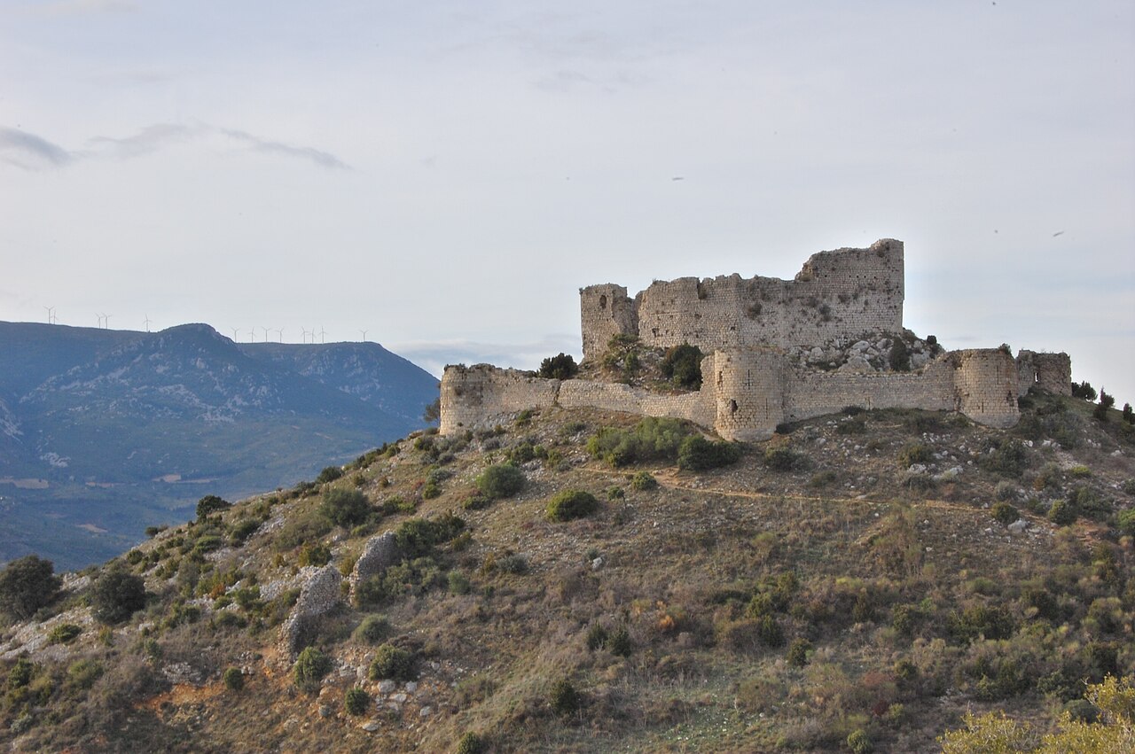
The Château de Padern stands as a compelling example of a medieval hill castle strategically perched on a limestone peak dominating the village of Padern and the Verdouble river in southern France. This fortress, built to leverage the natural steepness and ruggedness of its terrain, was virtually impregnable due to the challenging paths leading to it. Though less renowned than neighboring strongholds such as Termes, Quéribus, or Peyrepertuse, Château de Padern holds significant historical value as part of the defensive network in the region during the High Medieval period.

The earliest mention of the village of Padern dates back to the year 899, when Charles III, known as Charles the Simple, granted the territory to the Abbey of Lagrasse. At that time, the area was under the influence of the Counts of Toulouse rather than the direct control of the French crown. By 1026, a fortified structure at the site was documented, marking the castle's initial role in regional defense. Towards the end of the 12th century, a secondary fortification, or "forcia," was established under the Abbey's control, underscoring the site's strategic importance.

Historical context and ownership

During the turbulent years of the Albigensian Crusade in the early 13th century, Château de Padern was seized by Chabert de Barbeira, a companion of Olivier de Termes and lord of Quéribus. Chabert was a protector of the Cathars and resisted the crusading forces. After the fall of Quéribus, he negotiated his freedom by surrendering several citadels, including Château de Padern, to King Louis IX, bringing the fortress under French royal authority.

In 1283, the Abbey of Lagrasse formally reacquired the castle through a transaction with King Philip III of France, known as Philip the Bold. The Abbey retained ownership until the late 16th century, reflecting a long period of ecclesiastical stewardship. Following the Wars of Religion, the castle was purchased by Pierre de Vic, a nobleman from Girona in Catalonia. He undertook renovations that maintained the fortress's feudal character despite some modifications. The Vic family held the property until 1706, when it was sold back to the Abbey of Lagrasse, which eventually abandoned the site by the end of the 18th century.

Architectural features and strategic position

Château de Padern was constructed primarily from local stone, adapted to the contours of the craggy limestone outcrop on which it stands. Its design emphasized natural defenses, with steep slopes and difficult access paths that made direct assault nearly impossible. The castle controlled the entrance to the Verdouble river gorge, a vital natural passage in the region.

The secondary fortification added in the late 12th century likely served as an auxiliary defensive outpost or guard post, enhancing the castle's security. Although specific details of the internal layout are scarce, the fortress would have included thick defensive walls, towers, and possibly a keep or donjon, typical of High Medieval military architecture.

Modifications made by Pierre de Vic in the late 16th century respected the castle's medieval character, preserving its feudal fortress style despite the evolving needs of the time. The proximity of the castle to the village is notable; a narrow footpath of about two meters separates the base of the limestone slopes from the nearest houses, illustrating the close relationship between the fortress and the local community.

Decline, preservation, and current status

By the 18th century, the castle was abandoned by the Abbey of Lagrasse, leading to its gradual decline into ruins. In 1939, the local municipal council requested military engineers to demolish the castle, likely due to safety concerns. However, demolition was deemed too dangerous and costly because of the unstable geology and the castle's close proximity to village homes.

In 1944, the castle and its surroundings were designated as a protected site of general interest. This protection was extended in 2017, incorporating Château de Padern into the broader "Puech de Bugarach and northern syncline ridge of Fenouillèdes" area, highlighting its significance within the regional natural and historical landscape.

Today, the castle remains in a state of ruins, with no active restoration efforts due to its lack of classification as a monument historique. The site is largely forsaken and continues to deteriorate, yet it remains an important cultural and historical landmark. Its imposing position and the remnants of its defensive structures offer a tangible connection to the High Medieval era and the complex history of the Fenouillèdes region.

Cultural significance and visitor information

Although Château de Padern is less famous than other Cathar castles, it contributes to the rich tapestry of medieval fortifications that define the landscape of southern France. Its history reflects the shifting allegiances and turbulent conflicts of the Albigensian Crusade, the influence of ecclesiastical powers like the Abbey of Lagrasse, and the impact of the Wars of Religion.

The castle's dramatic location and ruins attract visitors interested in medieval history, military architecture, and natural beauty. However, access is challenging due to the steep paths and the fragile condition of the ruins. Visitors should prepare for a physically demanding visit and respect the site's protected status.

Château de Padern remains a poignant symbol of the region's medieval heritage, offering insight into the defensive strategies and historical narratives that shaped the borderlands between the French crown and the Occitan territories.

Frequently asked questions (FAQ)

How do I get to Château de Padern?
Château de Padern is located on a limestone peak above the village of Padern in the Occitanie region of southern France. Access involves steep and rugged paths, so visitors should be prepared for a challenging hike and wear appropriate footwear.
What is the historical significance of Château de Padern?
The castle played a role during the Albigensian Crusade as a stronghold seized by Cathar sympathizers and later surrendered to the French crown. It was owned by the Abbey of Lagrasse for centuries and reflects the medieval defensive strategies of the region.
Can I visit the ruins of Château de Padern?
Yes, the ruins are accessible to the public, but there are no formal visitor facilities or guided tours. Due to the steep terrain and fragile condition of the ruins, visitors should exercise caution and respect the site's protected status.
When was Château de Padern built?
The castle dates back to the 11th century, with the earliest fortifications documented by 1026. It was expanded and modified through the 12th and 16th centuries.
Why is Château de Padern less known than other Cathar castles?
Unlike prominent castles such as Termes or Quéribus, Château de Padern did not play a major role in the Albigensian Crusade and remained under ecclesiastical control for much of its history, leading to less military prominence.

Information

Hill Castle

Sources & official resources

Verify the information above using these authoritative references.

Loading map...

Visitor reviews

No reviews yet. Been here? Write the first review and help other travelers!

Write the first review

Visited this castle? Share your experience

Your review helps other travelers and adds first-hand knowledge to our encyclopedia.
Write a review

(5/5)

0/2000 characters

Your review will be visible after admin approval

Nearby castles

4.4 km
Château de Quéribus — France castle

Château de Quéribus

Cucugnan, France

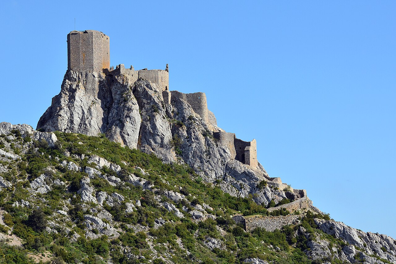
Château de Quéribus stands as a striking testament to medieval military architecture and the turbulent history of the Cathar movement in southern France. Located in the commune of Cucugnan, this hill castle commands a strategic position atop a rocky peak, offering panoramic views of the surrounding Corbières massif and the plains of Roussillon. Its imposing ruins evoke the legacy of the 'Five Sons of Carcassonne,' a network of fortresses that once guarded the French border against incursions from the Kingdom of Aragon until the border shifted southwards in 1659. First recorded in 1021, Quéribus initially served as a fortified stronghold within the viscounty of Peyrapertusès, under the influence of the Counts of Besalú and later the Counts of Barcelona. Its early medieval origins are reflected in its robust defensive design, which evolved significantly over the centuries to meet the changing demands of warfare and political power struggles in the region. Historical significance and cathar connections The castle's prominence rose notably during the High Medieval period, particularly in the 13th century when it became intimately linked with the Cathars, a religious group persecuted as heretics by the Catholic Church. Quéribus was reputed to be one of the last Cathar refuges following the fall of Montségur in 1244. It was held by prominent Cathar sympathizers such as Chabert de Barbaira and served as a sanctuary for Cathar leaders including Benoît de Termes, a Cathar bishop who died there before 1233. In 1239, the castle was transferred to the French crown following its sale by Nuno Sanche of Roussillon to King Louis IX. The fortress was besieged and surrendered in May 1255 after a campaign led by Olivier de Termes, marking the effective end of organized Cathar resistance. The subsequent Treaty of Corbeil in 1258 established the border between France and Aragon near Quéribus, cementing its role as a royal French fortress and one of the strategically vital 'five sons of Carcassonne.' Architectural features and defensive design Location and layout Perched between 628 and 728 meters above sea level, Quéribus occupies the highest peak for miles, making it a formidable natural fortress. The castle's architecture is arranged in three successive defensive enclosures that ascend the summit and cliff face, reflecting a layered approach to defense developed over four centuries. This vertical layout maximizes the natural topography for protection and surveillance. Defensive elements The castle incorporates a variety of medieval military features designed to repel attackers. These include chicanes—winding passages that hinder direct assaults, narrow arrow slits optimized for crossbow use, and wider cannon embrasures installed in later periods to accommodate firearms. The presence of machicolations allowed defenders to drop projectiles on enemies at the base of the walls, while murder holes inside the gates provided additional layers of protection. Strong gatehouses equipped with portcullises and hoardings—temporary wooden balconies—enhanced the castle's defensive capabilities. The battlements featured walkways for guards, and casemates provided sheltered positions for monitoring and defense. The relatively small size of the fortress and limited cistern capacity indicate it was intended to support a modest garrison of around 15 to 20 defenders, emphasizing its role as a strategic lookout and refuge rather than a large military base. The donjon: a unique gothic stronghold The heart of the castle is its polygonal donjon, situated in the uppermost defensive enclosure atop the cliff. Its walls are several meters thick, designed with multiple angled faces to deflect projectiles effectively. Inside, the donjon features a Gothic-style hall divided into two main chambers: a cellar below and a principal room above illuminated by a large window, an unusual feature for such a defensive structure. A notable architectural highlight is the ribbed vaulted ceiling supported by a central pillar with a pyramidal base dating to the 13th century. This pillar once upheld a wooden floor separating the two levels and indicates the presence of a chapel within the donjon, a rare and significant feature in medieval castles. The remains of a fireplace against the west wall suggest provisions for heating, enhancing the donjon's habitability. Access to the donjon's summit terrace is via a spiral staircase housed in an attached rectangular tower. From this vantage point, visitors can enjoy sweeping views extending to the Pyrenees mountains, the Mediterranean Sea, and the vineyards of the Corbières, underscoring the castle's strategic surveillance function. Later history and restoration efforts Following its capture by Aragonese forces in 1473, Quéribus remained a military asset until the Treaty of the Pyrenees in 1659 redefined the Franco-Spanish border along the Pyrenees, rendering the castle strategically obsolete. A garrison lingered for some decades, but by the late 18th century, the castle was largely abandoned and fell into disrepair, becoming a refuge for bandits during the French Revolution. Recognized for its historical and cultural value, the castle was declared a historic monument in 1907. Archaeological excavations in the 1980s revealed evidence of occupation dating back to the Iron Age and the Merovingian and Carolingian periods, highlighting the site's long-standing strategic importance. Discoveries of residential structures on a platform below the castle suggest a settled community in its vicinity over the centuries. Restoration began in 1951 with stabilization of the donjon's turret and continued through the late 20th century. A major restoration project between 1998 and 2002 focused on preserving the stonework, securing the walls, and adapting the donjon's roof into a terrace accessible to visitors. These efforts have ensured the castle's preservation as a significant cultural heritage site and a popular destination for tourists exploring the history of the Cathars and medieval fortifications. Cultural and natural heritage protection In addition to its status as a protected historic monument, the castle's surrounding landscape, including the nearby Grau de Maury and the village of Cucugnan, has been designated a natural and historic site since 1943, with further classifications added in 2017. This protection safeguards the unique environment and the panoramic vistas that contribute to the castle's dramatic setting and visitor appeal.

High Medieval (11th–13th c.)
Details
7.9 km
Château d'Aguilar — France castle

Château d'Aguilar

Tuchan, France

Château d'Aguilar is a remarkable example of a 12th-century Cathar castle located near the village of Tuchan in the Aude département of southern France. Perched on a rocky hill 321 metres above sea level, this hill castle commands sweeping views over the Corbières massif and the surrounding plains, highlighting its strategic military importance throughout the High Medieval period. Its architecture reflects the practical and evolving defensive needs of the 12th and 13th centuries, with a combination of an inner keep and an outer pentagonal fortification designed to protect against increasingly sophisticated siege tactics. Originally built by the Termes family in the 12th century, the castle's earliest structures replaced an even older fortification dating back to at least 1021, when the site belonged to the counts of Fonnollède. The castle's name, Aguilar, is derived from the Latin for "eagle's nest," which aptly describes its commanding position overlooking key routes between Narbonne and Roussillon. Over the centuries, Château d'Aguilar played a pivotal role in the turbulent history of the region, including the Cathar Crusades, the Albigensian Crusade, and the ongoing conflicts between French and Spanish powers along the border. Architectural design and features The castle's layout is a testament to the military architectural innovations of the medieval period. The core of the fortress is an inner hexagonal keep dating from the 12th century, surrounded by a larger pentagonal outer enceinte constructed in the 13th century. This outer wall was deliberately oriented so that its pointed bastion faced the most vulnerable approach, demonstrating careful strategic planning. Each corner of the inner fortification is reinforced with semi-circular guard towers, equipped with narrow arrow slits to provide defenders with protected firing positions. The outer pentagonal wall is fortified by six semi-circular towers, which were designed to maximize defensive coverage and allow archers and crossbowmen to repel attackers effectively. The masonry techniques evolved between the two construction phases: the inner keep features roughly hewn stones typical of the early medieval period, while the outer walls exhibit more refined stonecutting and horizontal courses indicative of advanced 13th-century craftsmanship. The walls were strengthened internally with rubble infill to absorb impact from siege engines. Notably, Château d'Aguilar lacks a traditional central donjon or large keep, which is unusual for castles of this era. Instead, its defense relies on the layered fortifications and the natural elevation of the hill. The entrance was protected by a barbican, a fortified gateway structure that added an extra layer of security on the southern slope. Beneath the keep lies a small underground chapel of Saint-Anne, a rare feature that illustrates the spiritual dimension of the castle's inhabitants. Fortified village and underground structures Adjacent to the castle was a fortified village to the south, remnants of which survive as fragments of defensive walls. Archaeological excavations have uncovered vaulted underground chambers with robust barrel vaults, likely used for storage or as shelters during sieges. Finds include religious ornaments and a variety of military equipment such as crossbows, iron helmets, shields, and hundreds of bolts, underscoring the dual religious and martial character of the site. Historical significance and events The history of Château d'Aguilar is deeply intertwined with the Cathar Crusades and the political upheavals of southern France in the 12th and 13th centuries. The site was originally under the control of the counts of Fonnollède and later the viscounts of Carcassonne. In 1210, during the Albigensian Crusade, the castle was seized by Simon de Montfort, a leading crusader commander. The owner at that time, Raymond de Termes, was captured and imprisoned in Carcassonne, reflecting the brutal nature of the conflict. For the next three decades, the castle remained relatively quiet until Oliver de Termes, Raymond's son, reclaimed it during a brief revolt against the crusaders. Aguilar then became a refuge for faydits—dispossessed Cathar knights and lords without strongholds—highlighting its role as a bastion of resistance. In 1246, a royal garrison was installed to oversee the frontier with Aragon, marking the castle's incorporation into the French royal domain. Oliver de Termes eventually allied with King Louis IX, who purchased the castle in 1260. Despite its formidable defenses, Château d'Aguilar faced repeated sieges and occupations by various forces, including mercenaries and Spanish troops, reflecting the ongoing conflicts along the Franco-Spanish border. Notably, in 1387, mercenaries briefly captured the castle before being expelled by Aragonese forces. The 16th century saw further turmoil, including capture by Spanish forces under Emperor Charles V in 1525 and occupation by German mercenaries in 1542, before returning to French control in 1544. Decline and modern status Following the Treaty of the Pyrenees in 1659, which shifted the Franco-Spanish border southwards, Château d'Aguilar lost its strategic importance. It was gradually abandoned and fell into ruin by the late 16th century. Today, the castle stands as ruins, with substantial sections of walls and towers still visible, along with the chapel and other structural remains. Since 1949, Château d'Aguilar has been officially protected as a monument historique by the French Ministry of Culture, recognizing its cultural and historical significance. It is also known as one of the "Five Sons of Carcassonne", a group of castles famed for their defensive strength and architectural ingenuity along the border region. Visiting château d'aguilar today Visitors to Château d'Aguilar can explore the extensive ruins that vividly illustrate the castle's layered history and military architecture. The site offers panoramic views over the Corbières and the surrounding landscape, providing insight into the strategic considerations of medieval castle builders. The remains of the chapel and the underground vaulted chambers add to the site's unique character, blending martial and spiritual heritage. As a protected historical monument, the castle is accessible to the public, though facilities are limited due to its ruinous state. Visitors interested in medieval history, military architecture, and Cathar heritage will find Château d'Aguilar a compelling destination within the rich cultural landscape of southern France. Overall, Château d'Aguilar stands as a significant testament to the complex history of the Languedoc region, embodying the military, religious, and political struggles that shaped medieval France and its borderlands.

High Medieval (11th–13th c.)
Details
8.2 km
Château de Peyrepertuse — France castle

Château de Peyrepertuse

Duilhac-sous-Peyrepertuse, France

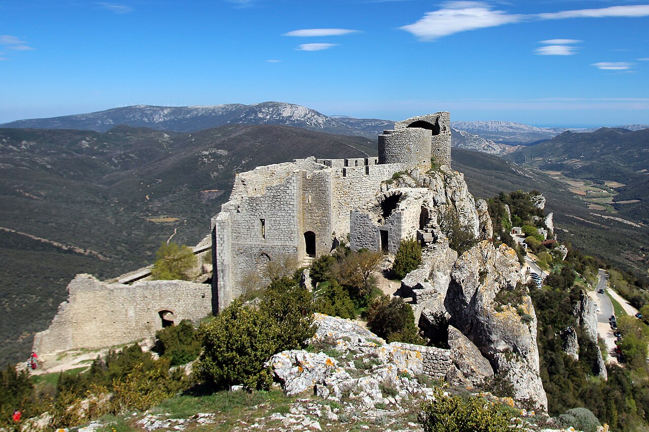
Château de Peyrepertuse stands as one of the most iconic and imposing Cathar castles in the French Pyrenees, perched dramatically atop a limestone ridge in the commune of Duilhac-sous-Peyrepertuse. This hill castle is renowned for its breathtaking location on cliffs rising 30 to 40 meters, offering commanding views over the surrounding landscape. Its strategic position and vast size have earned it a reputation as the largest among the so-called "Five Sons of Carcassonne," a group of fortresses that guarded the historic borderlands between France and Aragon. The castle's origins trace back to antiquity, with archaeological evidence confirming human occupation of the site since the 1st century BCE. The earliest historical records date from the early medieval period, specifically around 806 AD, when the fortress was known as Perapertusès under Catalan influence. Over the centuries, the castle passed through the hands of the Count of Besalú, the earldom of Barcelona, and the viscountcy of Narbonne, reflecting the complex feudal and political dynamics of the region. Historical significance and political context By the late 12th century, Peyrepertuse had become a crucial military stronghold on the frontier between the Kingdom of France and the Kingdom of Aragon. The castle's prominence grew during the Albigensian Crusade in the early 13th century, a campaign aimed at eradicating the Cathar heresy. At this time, the fortress was held by Guillaume de Peyrepertuse, a nobleman excommunicated for his Cathar sympathies. After the fall of nearby Carcassonne to crusader forces, Guillaume surrendered the castle to King Louis IX of France in 1240, marking its transition into French royal possession. Following this, the castle underwent significant reinforcement under royal direction. Between 1242 and 1251, the upper fortress known as the Sant Jòrdi donjon was constructed, perched at the highest point of the ridge. This addition, along with renovations to the older keep and the fortified Sainte-Marie church, transformed Peyrepertuse into a formidable border fortress. It was integrated into the defensive network called the "Five Sons of Carcassonne," alongside Quéribus, Puilaurens, Termes, and Aguilar castles, all strategically positioned atop rocky peaks to guard the frontier. Architectural features and layout Site and fortifications The castle extends along a limestone ridge approximately 300 meters long and up to 60 meters wide, situated around 800 meters above sea level. Its natural defenses are formidable, with steep cliffs on the southern side and a heavily fortified northern approach. The main entrance is located on the north, featuring robust curtain walls and two semicircular towers. A secret postern gate, now closed, once allowed discreet access via a narrow path and a detachable ladder, highlighting the fortress's defensive ingenuity. Lower castle and church The lower section of the castle contains the oldest structures, dating from the 12th century. Central to this area is the Romanesque Sainte-Marie church, notable for its vaulted apse and remnants of its vaulted ceiling and altar. Adjacent to the church lies the old keep, comprising the church itself and an adjoining residential building with two vaulted chambers stacked vertically. The castle's water needs were met by four cisterns, capable of holding between 12 and 40 cubic meters, essential for sustaining inhabitants during sieges. Upper fortress and donjon sant jòrdi The Sant Jòrdi donjon, constructed in the mid-13th century, crowns the ridge and represents the castle's most elevated and defensible point. Accessed by the steep Saint Louis staircase carved into the rock face, this upper keep features its own defensive walls and a single-nave chapel dedicated to Saint George. The battlements across the fortress are topped with crenellations, with square merlons pierced by narrow arrow slits, allowing defenders to fire while remaining protected. The governor's residence included shovel-shaped arrow slits for wider defensive angles. Defensive systems and daily life The castle's defensive architecture reflects the military technologies and strategies of the medieval period. The curtain walls and towers provided overlapping fields of fire, while the secret postern gate allowed for covert movement. The presence of domestic ovens and a vaulted passage leading to the spring known as Font de la Jaqueta ensured the castle's self-sufficiency during prolonged sieges. Building materials were primarily local limestone, with timber and metal fittings brought from nearby forests and workshops, lifted into place using a medieval hoisting device likely similar to a "cage à écureuil" or squirrel cage pulley. Later history and preservation Throughout the late medieval period, Peyrepertuse remained a key royal fortress guarding the French border against the Crown of Aragon and later Spain. The castle was restored in 1355 and briefly served as a refuge for Henri de Trastámara, a pretender to the Castilian throne. In 1542, it was seized during the religious conflicts by Jean de Graves, a Protestant lord, but was quickly recaptured. Its military importance waned after the Treaty of the Pyrenees in 1659, which moved the border southwards, leading to its gradual abandonment during the French Revolution. Sold as national property in 1820, the fortress fell into ruin. Preservation efforts began in 1950, stabilizing the ruins and opening the site to visitors. Today, Château de Peyrepertuse attracts nearly 100,000 visitors annually, celebrated for its dramatic setting, extensive ruins, and rich history. It has been protected as a historic monument since 1908 and is under consideration for UNESCO World Heritage status alongside other Cathar castles in the region. Cultural and touristic importance The castle's integration into the natural landscape, combined with its vast size and complex history, makes it a significant cultural landmark in southern France. Its ruins offer insight into medieval military architecture, Cathar history, and the turbulent border politics of the Middle Ages. The site also features climbing routes on the surrounding cliffs, connecting outdoor adventure with historical exploration. Visitors can explore the multiple courtyards, towers, chapels, and defensive walls, gaining a vivid impression of a fortress that evolved over centuries to meet the demands of warfare and political change. The preservation of the site ensures that this remarkable example of medieval fortification continues to educate and inspire future generations.

Early Medieval (5th–10th c.)
Details