Antonine Wall
The Antonine Wall (Latin: Vallum Antonini) stands as a significant Roman frontier fortification constructed during the 2nd century AD across the Central Belt of Scotland. Stretching from the Firth of Clyde in the west to the Firth of Forth in the east, this turf and stone-built barrier was the northernmost boundary of the Roman Empire in Britain for a brief period. It was conceived as a successor to the more famous Hadrian's Wall to the south, aiming to extend Roman control further into Caledonia, the land of the indigenous tribes known as the Caledonians.
Construction and architectural features
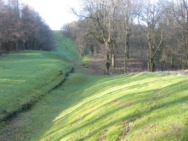
Commissioned by Emperor Antoninus Pius around AD 142, the wall was constructed primarily from turf laid on stone foundations. Unlike Hadrian's Wall, which was predominantly stone, the Antonine Wall's turf construction has made its remains less visible today. The wall originally measured approximately 63 kilometres (39 miles) in length, with a height of about 3 metres (10 feet) and a width near 5 metres (16 feet). On its northern side, a deep defensive ditch enhanced security, while it is believed that a wooden palisade topped the turf rampart to provide additional protection.
The wall's design included 16 main forts spaced at regular intervals, each serving as a garrison point for Roman troops. Between these forts were smaller fortlets that helped to monitor and control movement across the frontier. A military road known as the Military Way connected all the forts and fortlets, facilitating rapid troop movement and communication along the wall's length.
Historical context and military significance
The Antonine Wall was built during a period of Roman expansion under Antoninus Pius, who sought to push the empire's borders beyond Hadrian's Wall into hostile territory. Despite never visiting Britain himself, Antoninus Pius ordered the construction to strengthen Roman presence and deter the Caledonian tribes who resisted Roman rule.
Estimates for the wall's construction time vary, with most scholars suggesting between six and twelve years. The wall was actively garrisoned for only about eight years before the Romans retreated back to Hadrian's Wall, likely due to persistent pressure from local tribes and logistical challenges of maintaining such a frontier so far north.
Roman soldiers commemorated their efforts with decorative distance slabs, which marked the lengths of wall sections built by different legions. Around twenty of these slabs survive and provide valuable insights into the Roman military presence and the construction process.
Remains and preservation
Today, much of the Antonine Wall has been lost to time, agriculture, and urban development, especially since its turf and wood construction was less durable than stone. However, significant sections and archaeological sites remain visible and have been preserved under the care of Historic Environment Scotland. The wall and its associated forts are recognized as a UNESCO World Heritage Site, highlighting their cultural and historical importance.
Modern archaeological techniques, including Lidar scanning, have helped to map the wall's full extent and uncover hidden features beneath the landscape. These studies have confirmed the wall's length and the Roman use of precise distance measurements, enhancing understanding of Roman military engineering.
Legacy and cultural impact
The Antonine Wall represents a unique example of Roman frontier defense in Britain, illustrating the empire's northernmost reach and military strategy in the region. Though less famous than Hadrian's Wall, it provides crucial evidence of Roman interactions with native Scottish tribes and the challenges of maintaining distant borders.
Its remains continue to be a focus for historians, archaeologists, and visitors interested in Roman Britain. The wall's forts, ditches, and commemorative slabs offer a tangible connection to the Roman era and the complex history of Scotland's early medieval period.
Frequently asked questions (FAQ)
- When was the Antonine Wall built and by whom?
- The Antonine Wall was built starting around AD 142 by order of Roman Emperor Antoninus Pius as a northern frontier for the Roman Empire in Britain.
- What materials were used to construct the Antonine Wall?
- The wall was primarily constructed from turf laid on stone foundations, with a wooden palisade likely atop the turf rampart for additional defense.
- How long is the Antonine Wall and what features did it include?
- The wall stretched approximately 63 kilometres (39 miles) and featured 16 forts, smaller fortlets, a deep ditch on the northern side, and a connecting military road called the Military Way.
- Why was the Antonine Wall abandoned?
- The wall was abandoned about eight years after completion due to pressure from Caledonian tribes and logistical difficulties, leading the Romans to retreat to Hadrian's Wall further south.
- Can visitors see remains of the Antonine Wall today?
- Yes, although much has been lost, several sections and forts remain visible and are protected by Historic Environment Scotland as part of a UNESCO World Heritage Site.
Photo gallery

Information
Current owner
Historic Environment Scotland
Loading map...
Visitor reviews
No reviews yet. Been here? Write the first review and help other travelers!
Write the first reviewVisited this castle? Share your experience
Your review helps other travelers and adds first-hand knowledge to our encyclopedia.